Post contributed by Dr. A. Lucas. Research Scientist, Institut de physique du globe de Paris, France
A detailed analysis of both orbital and seismological data associated to the two largest seismic events recorded during the Nasa InSight mission to Mars (operational from the end of 2018 to the end of 2022), have been done by a team of researchers from the IPGP (Université Paris Cité / CNRS) and their colleagues. They have spotted a clear increase in the number of dust avalanches around the two epicenters of both quakes. The first seismic event was caused by an impactor hitting the Martian surface. The second seismic event was the largest marsquake ever recorded. This finding sheds light on how endogenous and exogenous processes can currently shape the surface of Mars and trigger active mass wasting.
Post contributed by Dr. Joe McNeil, Natural History Museum, London
Mars is a planet of geographic contrast. The southern highlands, which comprise the lower two-thirds of the planet form a rugged, heavily cratered landscape that are high in elevation and are some of Mars’ oldest terrains. The upper third of the planet – the northern lowlands – form lightly cratered plains, Mars is a planet of geographic contrast. The southern highlands, which comprise the lower two-thirds of the planet, form a rugged, heavily cratered landscape that are high in elevation and are some of Mars’ oldest terrains. The upper third of the planet – the northern lowlands – form lightly cratered plains, are lower in elevation, and are much younger in age. Where the two hemispheres meet, they form a planetary-scale feature called the dichotomy boundary. One of the most important – and enigmatic – regions of Mars lies in the highlands just south of the boundary at a place called Mawrth Vallis (Image 1). The 650 km-long Mawrth Vallis channel carves its way through Noachian-aged (4.1—3.7 billion years ago) clay-bearing, layered deposits that underpin much of our understanding of the role of liquid water on early Mars (e.g. Bishop et al., 2008; Loizeau et al., 2012). Ongoing work has revealed that these clay-bearing, layered deposits were once much more extensive than they are today. The evidence for this is contained in a population of thousands of mesas, buttes, and hills (‘mounds’) that exist in the lowlands just north of the dichotomy. Image 1A shows the mound population north of the dichotomy within the study area, as well as an example of three individual mounds in Image 1B.
Image 1: Similar strata, different settings. (A) shows a topographic map of the Mawrth Vallis region, with lowlands (teal), highlands (brown), and dichotomy boundary (dashed red line). The mounds are shown as black shapes in the northern lowlands. Inset MOLA (Mars Orbiter Laser Altimeter) globe shows location and global context of the study area. Panels B1 and C1 are CTX (Context Camera) and HiRISE (High Resolution Imaging Science Experiment) images showing a typical mound and a crater in the highlands, respectively, which both exhibit similar dark and light-toned layering at the metre scale (panels B2 and C2; HiRISE IRB).
Post contributed by Dr. Eng. Bartosz Pieterek, Adam Mickiewicz University in Poznań and Polish Geological Institute – National Research Institute.
Despite the fact that the Martian surface has been intensively studied for several decades, we still do not fully understand the evolution of the Red Planet. Specifically, our insight into the compositional evolution of Martian magmas is limited, as most volcanic regions were modified or even buried by younger volcanic activity or other geological processes. But luckily not everywhere. By using high-resolution images provided by the Context Camera (CTX) and High Resolution Imaging Science Experiment (HiRISE), on board the Mars Reconnaissance Orbiter, coupled with their stereo-pair digital elevation models, we identified a group of small, kilometer-sized volcanoes in the Claritas Fossae region (examples in Image 1, full area in Image 2). These volcanoes are emplaced on an old and heavily fractured terrain that survived younger volcanic resurfacing event(s). The studied volcanoes, which do not show significant modification by erosion and therefore cannot be very old, show a composition that is different from most other young volcanoes and lava flows found elsewhere on Mars.
Image 1: Examples of studied volcanic edifices with their structural and stratigraphic relationships with the fractured terrain of the Thaumasia and Claritas Fossae regions. (a)The most common type of volcanic edifice occurringin Claritas Fossae. Based on cross-cutting relationships with the older fractured terrain, the volcanic activity has to be younger than the fracturing. This example has been produced using CTX image G17_024955_1524, centered at 27.3983°S and 255.0633°E. (b) This image presents an interesting example of two volcanic edifices separated by a cliff attributed to faulting, which were likely supplied by the same subsurface dike. On Earth, similar-looking edifices may be formed due to the small difference in elevation between vents as evidenced by the Fagradalsfjall eruption (Phase 2; April 2021) in Iceland (Barsotti et al., 2023). This view was produced using CTX image P18_008156_1516, centered at 28.2575°S, and 254.6175°E. All images are available in NASA’s PDS system.
Post contributed by Dr. David A. Vaz, Centre for Earth and Space Research, University of Coimbra.
Mars lost a part of its atmosphere to space, a process that transformed the planet from a wet planet into a cold and arid place. The extension and timing of this climatic change are still uncertain. To assess the magnitude of this environmental change we must investigate the Martian geological record. Sedimentary deposits of aeolian origin are common on Mars (Image 1) and may provide valuable information about Martian environmental changes. However, we first need to understand how the diverse bedforms that exist on Mars’s surface form, and evaluate the boundary conditions that control their morphologies. Particularly, relationships between the size of aeolian bedforms and variable atmospheric density may be used to interpret the sedimentary record and infer paleo-environmental conditions through time.
Image 1: Barchan dune covered by dark-toned ripples with spacings between crests of ~3 m. These bedforms are migrating over brighter-toned transverse aeolian ridges (TARs). HiRISE image ESP_027864_2295_COLOR (credit: NASA/JPL/University of Arizona).
Post contributed by Dr Lisanne Braat, European Space Agency (ESA)
Deltas form when a river flows into a standing body of water. When the flow decelerates the sediment carried by the river settles and forms the delta. On Earth we have numerous active deltas where rivers meet lakes, seas, and oceans. Examples of Earth’s deltas can be seen on the left side of Image 1. On Mars, we observe many remnants of ancient deltas that are no longer active (shown on the right side of Image 1), such as the delta in Jezero Crater where the Perseverance rover currently explores. Preserved sediment deposits in these Martian deltas provide valuable insights into past processes on the planet’s surface and the presence of water. To better understand these landforms on Mars, we rely on knowledge gained from active delta systems on Earth. However, is it fair to do so when the gravity on Mars is much lower? How does gravity affect sediment transport and delta morphology?
Image 1: Animated GIF comparing Deltas on Earth and Mars. Left, examples of active deltas on Earth (source: Landsat). Right, examples of preserved ancient deltas on Mars (source: JMARS composite of CTX Global Mosaic, Murray Lab, and HRSC MOLA Blended DEM 200m v2).
Post contributed by Alistair Blance, The Open University, UK
During an impact on Mercury’s surface, material is ejected from the forming impact crater. As Mercury has only a tenuous atmosphere, ejected material travels predominantly ballistically, creating an ejecta deposit around the crater that thins gradually with increasing distance. However, large deposits emplaced by ground-hugging flows can be found around some impact craters on Mercury (Image 1). Evidence for flow includes material being diverted around obstacles, a steep edge or distal ridge at deposit margins, and a lobate shape to several examples. Some flow deposits extend outwards around a whole crater, but often they are confined within topographic lows adjacent to the crater. To help assess the origin of these features, it is useful to compare them to similar features across the Solar System. This comparison may also indicate how differences between the planets can influence the development of flows around craters.
Image 1: Flow deposits around craters on Mercury. Deposit boundaries indicated with red triangles. (A) Flow deposit extending from the central crater into an underlying crater in the top right of the image. Steep margins with a lobate shape suggest emplacement by flow. Image taken from MESSENGER MDIS BDR Global Basemap. (B) A crater with two sections of flow deposit extending into the underlying crater in the bottom right of the image. Image taken from MESSENGER MDIS frame EW0260906588G. (C) Sketch map of the image in B. Shows the two sections of flow deposit in red, with hypothesised direction of emplacement shown with red arrows. The deposit appears to have been diverted around a central peak within the underlying crater, providing evidence for emplacement via ground-hugging flow.
Post contributed by Dr Anna Grau Galofre, Laboratoire de Planetologie et Geosciences, CNRS UMR 6112, Nantes Universite, Universite d’Angers, Le Mans Universite, France.
Glaciers, ice sheets, and ice masses in general, are both agents of landscape evolution and a part of the landscape itself, when considered at human time scales, with surfaces that evolve and record changes in environmental conditions. The ages of glaciers and ice sheets on Earth, which range from thousands to millions of years, dwarf in comparison with the ages of debris-covered ice masses on Mars. Debris-covered martian ice deposits range up to hundreds of millions of years old, perhaps approaching 1 billion years old in some locations. Image 1 shows complex patterns on the surface of a debris-covered glacier on Mars. Terrestrial glacial surface deformation patterns can record changes in environmental conditions, which are also captured in the variability in chemistry and crystal structure seen in their internal stratigraphy. The morphology of a glacier surface, for example, may reflect episodes of warmer climate, and therefore enhanced ice flow; banding patterns may reflect periodic changes in the mass balance of ice accumulation and ice loss; and crevasses may reflect episodes when ice flowed relatively fast and fractured. The surface morphology of glaciers and debris-covered ice deposits can thus help us learn about the history of climate on Earth and Mars.
Image 1. Surface banding patterns on a debris-covered, cold based ice deposit (called a ‘lobate debris apron’) flowing down a canyon wall in Reull Vallis, Mars. Extract from CaSSIS image MY34_005511_224 (footprint width is 9 km). Image credit: ESA/CaSSIS.
The polar caps of Mars are gigantic ice deposits, similar in size to Texas or France, and mostly made up of frozen H2O. Like many planets and moons, Mars is littered with impact craters – the scars of violent asteroid and comet collisions. Near to but separated from the polar caps, some craters on Mars are home to mounds of frozen H2O ice. These “ice mounds” are much smaller than the giant polar caps, but not tiny—think the size of Rhode Island or Luxembourg instead of Texas or France—and have been discovered in dozens of craters using robotic spacecraft that collect images of the surface from Martian orbit. An example of one ice mound is shown in Image 1.
Image 1. Ice mound located in Korolev Crater in the north polar region of Mars. The ice mound is about 37 miles (60 kilometers) wide. Image is a perspective view made from data returned by ESA’s Mars Express spacecraft.
Post contributed by Dr. Zach Dickeson, Department of Earth Sciences, Natural History Museum, London, UK.
At geological timescales, individual lakes are only transient features on the Earth’s surface. Conditions within lake basins change over time, eventually filling with sediment, drying up, or draining completely by steady erosion (or catastrophic breach) of the basin margin. Sites where lakes existed in the past are known as palaeolakes, and in addition to Earth, hundreds of examples have been identified on Mars (Goudge et al., 2015). Rather than a single characteristic landform, palaeolakes on Mars are typically identified by a set of topographic and morphological features such as shown in Image 1. Careful investigation of associated river valleys, deltas, layered deposits, and shoreline terraces can reveal details of a lake’s origin, development, and eventual demise (Dickeson et al., 2022).
Image 1: Deposits and landforms within a palaeolake in Arabia Terra, Mars. Two past lake levels are represented by contours defined by outlet valley elevations. The inlet valley is visible at the bottom of the image where it enters the palaeolake basin. A broad, flat-surfaced sediment fan with a steep front sits at a higher elevation, and is incised through by the inlet valley, which continues into the basin to terminate at the apex of a lower and more heavily weathered sediment fan. The two fans are interpreted as deltas, and match the two different fill levels within the palaeolake. Context Camera image D12_031993_2114_XN_31N014W; http://viewer.mars.asu.edu/viewer/ctx/D12_031993_2114_XN_31N014W; NASA/JPL/MSSS/University of Arizona.
Post contributed by Dr Alex Morgan, Planetary Science Institute, USA
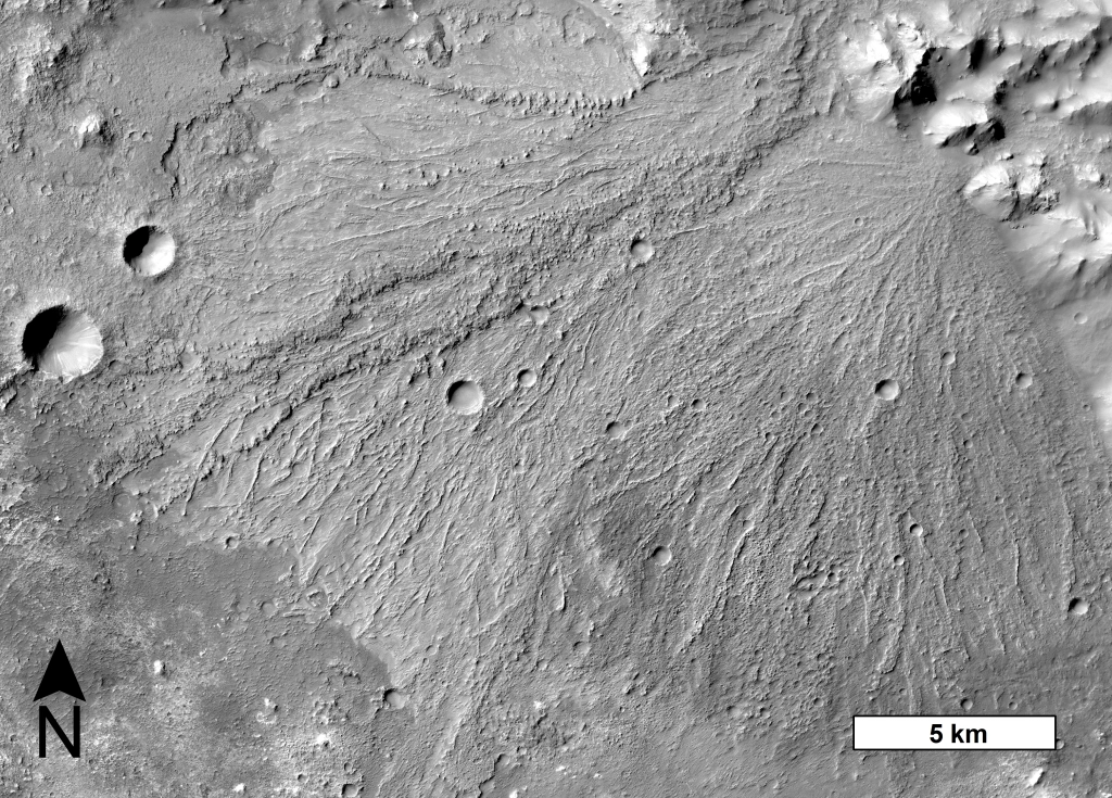
Alluvial fans are sedimentary deposits that form at the base of mountain fronts as a channel exits a steep, confined valley onto more gently sloped and unconfined terrain (Image 1). The channel loses its ability to transport sediment due to the reduction in slope and the lateral expansion of flow, and over time sediment is deposited into a semi-conical shape. The effects of water on a landscape are the most unambiguous markers of past climatic environment, and the distribution of alluvial fans provides a record of where and when liquid water was capable of transporting sediment on Mars in the past. Furthermore, as depositional features in close proximity with their sediment sources, alluvial fans preserve a record of environmental changes that occurred while sediment was being transported and deposited. In this study, we leveraged high resolution images from the CTX camera on Mars Reconnaissance Orbiter, which cover the entire surface of Mars, to conduct a global survey for fan-shaped sedimentary landforms across the martian surface and explore their implications for environmental change.
Image 1: A large alluvial fan in Harris crater, centered on 21.5°S, 67°E. The down-fan-trending ridges are interpreted to be paleochannels now in inverted relief due to preferential erosion of finer overbank deposits. This particular fan exhibits evidence for multiple episodes of sedimentation (Williams et al., 2011). CTX image G02_019160_1580_XN_22S292W.
Post contributed by Dr. Petr Brož, Institute of Geophysics of the Czech Academy of Sciences.
Kilometer-sized flows (KSFs) have been observed in many regions on Mars and have typically been interpreted as lava flows. However, sedimentary volcanism has been proposed as an alternative origin for some martian KSFs. Remarkable examples of such hypothesized sedimentary KSFs are located at the southern margin of Chryse Planitia, a large impact basin that has been partly infilled by sedimentary strata. There, dozens of such flows (Images 1 and 2) are associated with >1000 conical and dome-shaped edifices that have been previously interpreted to result from subsurface sediment mobilization (Komatsu et al., 2016, Brož et al., 2019); however their formation mechanism still remains enigmatic due to the absence of ground truth. To get deeper insight about the formation of these KSFs we generated seven Digital Elevation Models computed from HiRISE stereo pair images enabling us to reveal their detailed, meter-scale morphology (Image 2). As a result, we have been able confirm that KSFs are indeed aggradational edifices formed by the movement of a low viscosity liquid (Image 2b). Several of the observed morphologies associated with these flows suggest that such liquid had to be a mixture of water and sediment, i.e., mud, rather than silicic lava. In such a case, the southern part of Chryse Planitia is a region on Mars where subsurface sediment mobilization could have operated in the past and hence represents a promising site for future exploration where deeper-sourced sedimentary deposits are exposed at the surface.
Image 1: An example of kilometer-sized flow in Chryse Planitia consisting of three main parts as captured in CTX image P17_007639_1997_XN_19N034W, centered 19.85°N, 326.02°E).
Post contributed by Emily Bamber (PhD Candidate), Jackson School of Geoscience, University of Texas at Austin
Impact craters are a common feature of the surface of Mars and other planetary bodies. Impact craters are formed by the force of an asteroid or comet colliding with the surface of a planet. This collision excavates a bowl-shaped depression and causes uplift, deformation and deposition of excavated material to form a crater rim, which can rise hundreds of meters above the surroundings (for a crater on the scale of tens of kilometers in diameter). However, some of Mars’ impact craters stand out from their counterparts on other rocky planets and moons because they have been affected by the action of erosion by liquid water. In comparison to the Moon, Mars’ craters deviate much more from their original geometries, but perhaps more strikingly, more than 400 craters on Mars’ surface have an inlet valley (Image 1); a valley which starts from outside the crater and crosses the rim crest (e.g. Cabrol & Grin, 1999; Goudge et al., 2016). Although no substantial liquid water currently flows on Mars today, the preserved valleys likely delivered water from a crater’s surroundings to the crater interior, at some time in the distant past. Therefore, their formation could give clues to Mars’ watery past.
Image 1: An impact crater on Mars, at 16.2°N, 53.2°W with a high-standing crater rim around its circumference. To the south of the crater, there is an inlet valley that crosses the rim divide, with two wide tributaries. The valleys are now dry, but liquid water in Mars’ past likely incised them. The crater does not have an outlet valley (where water may have exited the crater in a through-flowing system). Background is a CTX DEM (from the stereo pair B21_017806_1955 – B21_017951_1955), HRSC DEM h2277_0000 and global MOLA DEM, overlain on CTX image B21_017806_1955 and THEMIS global IR mosaic.
Post contributed by Dr. Matthew Chojnacki, Planetary Science Institute, Lakewood, CO, USA.
Megaripples, which are intermediate-scale aeolian bedforms as compared with ripples and dunes, have been studied extensively on Mars and thought to be largely inactive landforms from past climates. On Earth, “megaripples” can be 30 cm to tens of meters in spacing with an abundant coarse sand population resulting in reduced migration except for very strong storm events. We mapped the extensive sand seas across the north pole of Mars for the presence of Martian megaripples (Image 1).
Image 1. HiRISE perspective view of north polar dune fields with active megaripples (arrows). Megaripple activity is most evident on the upwind edges of dune fields and in some cases within inter-erg areas. Clusters of contiguous megaripple fields often flanked by ripples and dunes were most common, while occasionally occurrences of mobile megaripple trains atop of bedrock were observed. All images and associated digital terrain models can be accessed at: https://hirise.lpl.arizona.edu/ Credit: NASA/JPL/University of Arizona.
Post contributed by Dr Joel Davis, Department of Earth Sciences, Natural History Museum, UK
On Earth, the interplay between tectonics and sedimentation is commonplace. In regions such as Death Valley, USA, extensional tectonic processes have formed sedimentary basins, where the subsequent erosion of the landscape causes the formation of features such as alluvial fans. Alluvial fans are conical-shaped, sedimentary deposits usually formed by stream flows in upland regions. Later tectonic activity can lead to the deformation and relative uplift of these landforms. A new generation of alluvial fans may then form, overprinting the older generation and extending down to the new position of the basin floor.
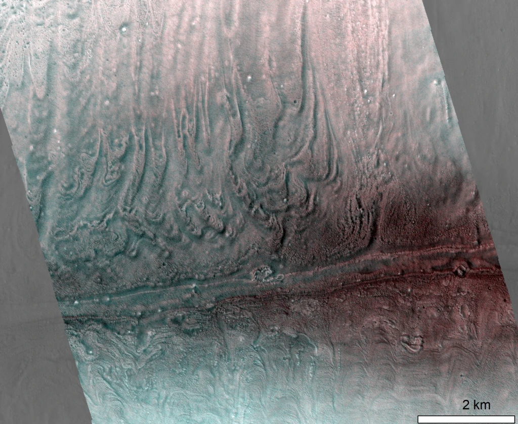
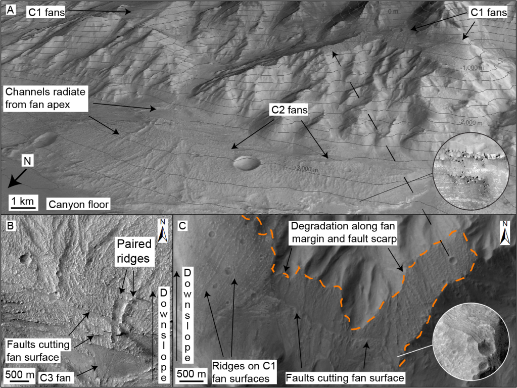
To contrast, as most alluvial fans on Mars are found within impact craters, they do not show evidence of tectonic deformation. The alluvial fans hosted within the canyons of Valles Marineris appear to be an exception to this (Figure 1). Valles Marineris may have developed over billions of years by repeated episodes of normal faulting. In several regions of Valles Marineris, not only are alluvial fans found on the current floor, but remnants of such features are found on the canyon walls as well – perched several kilometres above the floor!
Figure 1: Faulted alluvial fan deposits in Coprates Chasma, Mars. (A) Oblique Context Camera (CTX) image of multiple generations of alluvial fan deposits, offset by faulting. Credit: NASA/JPL/MSSS. Inset shows High Resolution Imaging Science Experiment (HiRISE) image of bright-toned layering in fan margins. Topographic contour interval is 200 m. Credit: NASA/JPL/UoA. (B) HiRISE mosaic of C2 alluvial fan deposits on canyon floor, where surfaces contain distributary channels and paired ridges, cut by multiple faults. Youngest C3 fans superpose faults and are local to C2 fan apices. Credit: NASA/JPL/UoA. (C) Planform CTX mosaic of oldest (C1) alluvial fan deposits (perched terraces), which have been faulted and later eroded (orange line). NASA/JPL/MSSS. After Davis et al., 2021.
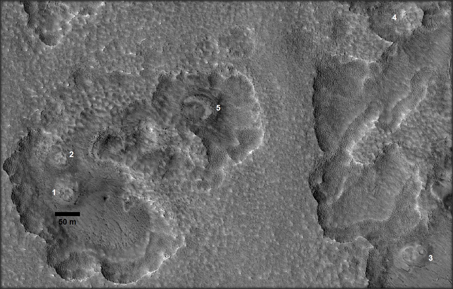
Cones are common landforms arising from volcanism on Earth and can be observed on other terrestrial planets. Mars hosts small conical hills known as mounds – these positive relief features have been reported in several locations over the Martian surface (Brož et al., 2017; Hemmi & Miyamoto, 2017) and inside craters such as Firsoff, Becquerel, Kotido, and Crommelin in southwestern Arabia Terra (cf. McNeil et al., 2021; Pondrelli et al. 2015). Various processes have been proposed for the development of mounds on Mars, including mud volcanism, monogenetic or small-scale volcanism, preferential erosion of sedimentary units, and diapir-like discharge of sediment-laden fluid. Sedimentary origins have been previously hypothesized for the mounds found on crater floors (Pondrelli et al., 2011; Pondrelli et al. 2015). In that context, we identify previously unrecognized evidence of intrusive igneous process at the center of an unnamed ∼85-km diameter floor-fractured crater (FFC, Bamberg et al., 2014) in North-Central Arabia Terra (Image 1). We consider whether the observed geomorphic features are related to impact-induced volcanism or to regional intrusive activity during the late Noachian to early Hesperian periods of Mars (~3.6 Ga; Rani et al., 2021).
Image 1:Thermal Emission Imaging System daytime Infrared image mosaic of the studied Floor-Fractured Crater in the eastern Arabia Terra region, overlain by color-coded Mars Orbiter Laser Altimeter and High-Resolution Stereo Camera elevation map. The black box in the center of the crater shows the location of the mounds and ridges (See Image 2). The location of the crater is marked by a yellow star in the inset global map of Mars. Image credits: HRSC-MOLA Blended DEM Global 200m v2, USGS/DLR/NASA/Goddard Space Flight Center. THEMIS-IR Day Global Mosaic 100m v12, THEMIS team/ASU
Post contributed by Meven Philippe, Ph.D student, Laboratoire de Planétologie et Géodynamique de Nantes, CNRS/Université de Nantes, France.
On Earth, sharp drops of temperature below 0°C can cause the ground to contract and fracture, forming thermal-contraction cracks. These cracks can connect in a network, which leads to a ground that shows a polygonal pattern. Ice or sand can then seasonally aggrade as wedges into these cracks, which uplifts polygons’ margins to higher elevations than their centres, thus forming low-centered polygons. When the infilling material degrades, the elevation of the margins reduces with respect to that of the centre, thus forming high-centered polygons. The same processes are assumed to occur on Mars in the mid-latitudes. Image 1 (42.9°N, 115.43°E) is located in Utopia Planitia, a lowlands plains area in the martian Northern hemisphere where numerous potential periglacial morphologies have been described.
Image 1: Polygonal patterned ground in a crater in Utopia Planitia, Mars. The blue circle highlights examples of low-centred polygons, the red circle highlights examples of high-centred polygons. The black arrow points out the sharp border between the polygonised unit and another one, non-polygonised. Illumination is from the left. Credits: HiRISE image ESP_036366_2235 – NASA/JPL/University of Arizona.
Post contributed by Adomas Valantinas, Physikalisches Institut, Universität Bern, Switzerland.
Slope streaks are linear, fan-shaped and sometimes anastomosing dark markings that form frequently on equatorial Martian slopes. Image 1 shows examples of these features imaged by the Colour and Stereo Surface Imaging System (CaSSIS) on board ExoMars Trace Gas Orbiter. Slope streaks are found on steep slopes but can also initiate on gentle slopes well below the angle of repose. They can propagate for many hundreds of meters and pass around obstacles. Unlike many other seasonal features on Mars, which form and fade periodically, slope streak markings remain visible for several decades after their formation. Some dark streaks have been observed to transition into bright streaks over time. Therefore, these features represent a unique phenomenon that provide important insights into Mars’ dynamic surficial and atmospheric processes.
Image 1: Bifurcating morphology of dark slope streaks on a crater wall in the Mars’ equatorial latitudes (9.19°N, 39.60°E). Note the streaks’ ability to go around obstacles, their sharp boundaries, and their digitate termini. CaSSIS ID: MY36_015777_009_1. Credit: ESA/Roscosmos/University of Bern.
Post contributed by Dr Colman Gallagher, UCD School of Geography and UCD Earth Institute, University College Dublin, Ireland.
Viscous flow features occur in the mid-latitudes of Mars and have characteristics consistent with being debris-covered glaciers. Climate models suggest that martian glaciers are cold-based systems in which meltwater has never been widely produced but Gallagher et al. (2021) described a widespread assemblage of landforms in Phlegra Montes (Image 1) that are morphologically analogous to landforms classified by Glasser and Bennett (2004) as indicative of warm-based glacial erosion on Earth. This suggests that glaciers in this region produced meltwater in the past. Warm-based glaciers reach the melting point at their beds, allowing them to slide over their beds and erode the underlying landscape. Meltwater produced by warm-based glaciers can also flow across the bed and erode subglacial meltwater valleys. Landforms of glacial erosion identified by Gallagher et al. (2021) include zones of aerial scour, glacial troughs (Image 2), corries (cirques; Image 3), lee-side rock cavities, streamlined bedrock forms, rock grooves (Image 4), subglacial meltwater channels (Image 4), and tunnel valleys. This is in addition to a depositional glacial meltwater landform called an esker, which was discovered by Gallagher and Balme (2015) and you can read about in a previous post here.
Image 1. Elevation map of Mars showing the location of Phlegra Montes. Blue regions are low elevation and red/white regions are high elevation (MOLA elevation data credit: USGS, NASA, JPL).
Post contributed by Dr. Alexander Barrett, School of Physical Sciences, The Open University, UK.
Transverse Aeolian Ridges (TARs) are a distinctive aeolian landform, commonly found on the surface of Mars (Balme et al., 2008; Bourke et al., 2006). They consist of metre to decimetre scale granular ripples, which form transverse (i.e. perpendicular) to the direction of the prevailing wind. Similar to terrestrial megaripples, TARs are believed to form through surface creep of coarse particles. Understanding the distribution of TARs is important for understanding the aeolian environment in which they formed (Favaro et al., 2021), and for planning rover missions (Balme et al., 2018). TARs present a potential hazard when they occur in rover landing sites. Consequently, a team at the Open University has trained a machine learning model called NOAH-H (developed by SciSys Ltd. for the European Space Agency; Woods et al. 2020) to identify these features, and distinguish them from other common surface textures (Barrett et al. 2021).
Image 1 shows bedforms in Oxia Planum. The size and prevalence of bedforms in this area is important, since it is the landing site for the ExoMars Rosalind Franklin Rover (Vago et al., 2017), which will arrive in 2023 to search for signs of past and present life in this once water-rich area (Quantin-Nataf et al., 2021). Large bedforms, or continuous regions of loose aeolian sand, could form navigational hazards, limiting the directions in which the rover can progress, or the science targets that it can access. We need to have a good understanding of the distribution of TARs in the immediate area where the rover will land, however this is not precisely known in advance and could be anywhere within a large landing ellipse. Mapping all of the TARs in the potential landing area by hand is impossible in the time available, even for a large team.
Image 1: Large TARs at the planned ExoMars Rosalind Franklin rover landing site at Oxia Planum, Mars (High Resolution Imaging Science Experiment (HiRISE) Image ESP_048292-1985. a) translucent layer showing Machine Learning produced terrain classification, overlying the red-band HiRISE image from which the classification was made. The area is dominated by rugged and fractured bedrock, while topographic lows contain non-bedrock material. This has been shaped into TARs of various sizes and degrees of continuity. The divide between bedrock and non-bedrock textures is well defined, as are the perimeters of patches of TARS. The transitions between textured, fractured and rugged bedrock are less well identified, as these features form a continuum, and so some areas have characteristics of multiple classes. HiRISE Image Credit NASA/JPL/University of Arizona.
Post contributed by Dr. Lauren Mc Keown, School of Physical Sciences, The Open University, UK.
Spiders are unusual branched landforms found among the high southern latitudes of Mars (Image 1). They have no Earth analogues and are often accompanied by fans and spots that appear in spring. They are proposed to form when sunlight penetrates the Martian south polar seasonal CO2 ice layer, causing ice at its base to change from ice to gas, and eventually crack. Escaping gas then scours the terrain beneath, carving spider-like patterns and depositing material on top of the ice via a plume (Kieffer et al., 2003). However, although this suggested process is well-accepted, it has never been directly observed on Mars. In order to investigate whether spider patterns could form by CO2 sublimation under Martian atmospheric pressure, experiments were performed (Image 2) at the Open University Mars Simulation Chamber, which simulates Martian atmospheric conditions.
Image 1: Examples of spiders on Mars (HiRISE image ESP_014282_0930). Left shows the ‘classic’ spider morphology which consists of a central depression and radial tortuous dendritic troughs emanating from its centre. Right is a context image. Image Credit: NASA/JPL/University of Arizona.
Post contributed by Dr. Alfred S. McEwen, Lunar and Planetary Laboratory, University of Arizona, USA.
Recurring slope lineae (RSL) are dark linear markings on steep slopes of Mars that regrow annually and likely originate from the flow of either liquid water or dry granular material. Following the great dust storm (or planet-encircling dust event) of Mars Year 34 (in 2018), the High Resolution Imaging Science Experiment (HiRISE; McEwen et al., 2007) on Mars Reconnaissance Orbiter (MRO) has seen many more candidate RSL than in typical Mars years (Image 1). These RSL sites show evidence for recent dust deposition and dust devil activity, so dust lifting processes may initiate and sustain RSL activity on steep slopes.
Image 1: RSL and dust devil tracks on a hill in the southern middle latitudes (41.1ºS, 187.4ºE). Inset shows some of the RSL at higher resolution. Hundreds of dark dust devil tracks are seen on the full image as the more diffuse lines that cut across topography. HiRISE image ESP_058122_1385, acquired after the 2018 dust storm. Credit: NASA/JPL/University of Arizona
Post contributed by Divya M. Persaud, University College London, UK/NASA Jet Propulsion Laboratory, USA.
This canyon, Sakarya Vallis, cross-cuts the central mound of Gale Crater, Mars, and was probably formed by fluvial erosion. Gale Crater, the exploration site of the Curiosity rover, has undergone a complex geologic history of aqueous and aeolian processes. The central mound is a topographic high in the center of the crater, on which the ~5.2 km peak Aeolis Mons is situated. This feature sports several canyons (which cut through it), yardangs, and spectacular exposed layers, and its origins are uncertain (likely aeolian and/or fluvio-lacustrine). Image 1 shows the largest canyon on the mound, at 26 km long, up to 3.5 km wide, and up to 400 m deep. The hundreds of meters of exposed layers in this canyon provide a glimpse into the depositional history of the central mound of Gale crater.
Image 1: A 3D perspective view of the interior of the channel, visualized from HiRISE Digital Terrain Model DTEEC_006855_1750_007501_1750_A01 and HiRISE image PSP_007501_1750. This view shows the exposed layers and a possible fracture on the eastern wall (left), while the topography of the bright, inverted feature can be seen on the floor of the canyon. The floor of the canyon is overlaid by ripples. The scalebar is oriented north.
The center of Sakarya Vallis is approximately 27 km from and 700 m higher in elevation than the base of Gediz Vallis, the approximate location of the Curiosity rover (as of February 2021, sol 3038). The layers exposed in Sakarya Vallis therefore represent later depositional events than those encountered by Curiosity to date. As the rover ascends the mound towards Aeolis Mons, this geology could help contextualize rover observations and constrain lateral differences in palaeoenvironment.
The canyon cross-cuts layered hydrated sulfates in the lower mound, while spectra of the upper mound point to a dust composition. The surface of the upper unit (Image 2) is an etched, yardang unit. Yardangs are streamlined features eroded by the wind.
Image 2: A) An overview of the canyon on the central mound from CTX imagery. The slope of the canyon is to the northwest. The surface of the mound is etched by yardangs and in-filled craters. B) A close-up view of the northern, lower half of the canyon, from HiRISE image PSP_007501_1750. The extent of the inverted feature can be seen on the floor.
Within the canyon are possible point bars formed by past rivers (Image 2), mass-wasting features (Image 3), ripples (Image 1), and boulder-scale lag deposits along the floor and clifftops. A bright, topographic feature resembling an inverted channel or meander belt (Image 1) extends along much of the canyon floor and may represent later flow of liquid water, and subsequent topographic inversion by erosion of materials surrounding the channel.
Image 3: Layers exposed in the northern part of the canyon in a possible mass-wasting feature (HiRISE image PSP_007501_1750). These layers are sub-horizontal and dip gently to the northwest. The ripples on the floor have wavelengths of 10-20 m.
Post contributed by Axel Noblet, Laboratoire de Planétologie et Géodynamique de Nantes, CNRS/Université de Nantes, France
Jezero Crater on Mars will soon be explored by NASA’s Perseverance rover. This crater has been interpreted as a paleolake. It contains two fan-shaped deposits in the northern and western portions of the crater. These deposits have been interpreted as ancient deltas. The delta located in the western portion of Jezero (Image 1) displays some of Mars’ best-preserved fluvio-deltaic features, and exhibits a variety of structures such as inverted channels and point-bar strata (Image 2). This delta contains a precious record of various depositional environments, and in situ exploration can give us insight of Mars’ fluvio-lacustrine history. The association of well-preserved lacustrine features with orbital detections of carbonates along the inner margin of Jezero points toward high biosignature preservation potential for these deposits. Hence Jezero’s western delta contains a record of the evolution of Mars’ ancient climate and possible habitability. The presence of a long-lived lake system on Mars is astrobiologically significant, and the deposits within the Perseverance landing site could have preserved biosignatures that could be investigated and cached for a future sample return mission.
Image 1: 3D view of Jezero western delta, looking north from the center of the crater. The data visualized here is a CTX camera orthorectified mosaic draped over a CTX digital terrain model (horizontal resolution: 20m/px). The triangular ‘birdfoot’ shape of the delta is clearly visible, and inverted channels can be seen radiating from the apex of the delta. The inlet valley goes diagonally from the upper left of the image through the delta deposits. The crater floor appears as the smooth terrains on the lower part of the image.
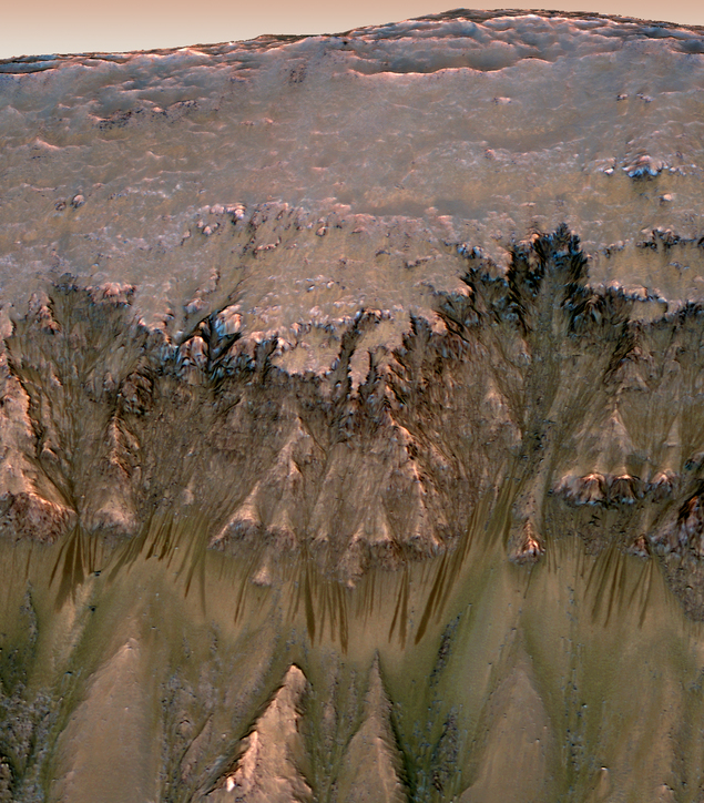
Gullies are found on steep slopes on the surface of Mars and appear as a linear-to-sinuous channel linking an alcove at the top to a fan at the bottom. The most interesting interpretation of the past two decades has been that the Martian gullies were carved by the flow of liquid water as discovered from the high-resolution images returned by the Mars Orbiter Camera (MOC) onboard “Mars Global Surveyor (MGS)” in 2000 (Malin and Edgett, 2000). Subsequent observations using MOC and the Mars Reconnaissance Orbiter (MRO) High Resolution Imaging Science Experiment (HiRISE) images revealed that Martian gullies are active today and that sublimation of seasonal carbon dioxide frost – not liquid water – could have played an important role in their formation. In our recent work using HiRISE images we reported global distribution of overlapping lobate deposits in gullies (Image 1) showing that a debris-flow like process may be responsible for gully formation (Sinha et al., 2020).
Image 1: Top: 3D view of gullies on the pole-facing wall of ~8 km diameter Los crater (35.08˚ S, 76.22˚ W) on Mars. HiRISE image ESP_020774_1445 (0.25 m/pixel) is draped over 1 m/pix HiRISE elevation model. The depth of crater floor from the crater rim is ~1 km in elevation and the image spans ~4 km from left to right. The box shows the location of bottom panel. Bottom: Image shows the gully fan surface within Los crater with overlapping lobate deposits, including convex-up and tongue shaped terminal lobes with lateral levees. HiRISE image credits: NASA/JPL/University of Arizona.
Post contributed by Helle L. Skjetne, PhD candidate, Department of Earth and Planetary Sciences, University of Tennessee, Knoxville, USA.
Chaos terrain is formed by disruption of preexisting surfaces into irregularly shaped blocks with a “chaotic” appearance (Image 1). This typically occurs through fracturing (that can be induced by a variety of mechanisms), and the subsequent evolution of these blocks can follow several paths (Image 2). These distinctive areas of broken terrains are most notably found on Jupiter’s moon Europa, Mars, and Pluto. Although chaos terrains on these bodies share some common characteristics, there are also distinct morphological differences between them (Image 1). The geologic evolution required to shape this enigmatic terrain type has not yet been fully constrained, although several chaos formation models have been proposed. We studied chaotic terrain blocks on Pluto, Europa and Mars to infer information about crustal lithology and surface layer thickness (Skjetne et al. 2020).
Image 1: Examples of chaotic terrain “blocks” (referring to each mountain-like topographic feature). Chaos on Pluto in a) Tenzing Montes and b) Al-Idrisi Montes, respectively (New Horizons image at ~315 m px–1), c) Hydraotes Chaos on Mars (Mars Odyssey THEMIS daytime infrared global mosaic at 100 m px–1), and d) Conamara Chaos on Europa (Galileo 210–220 m px–1 East and West RegMaps).
Post contributed by Adam J. Hepburn, Department of Geography and Earth Sciences, Aberystwyth University, UK.
Mars hosts abundant glacier-like landforms throughout its mid-latitudes, the presence of which necessitates major shifts in climate relative to present conditions. These ice-rich viscous flow features (VFFs) are typically found in coalescing, size-hierarchical systems whereby lower-order glacier-like forms (GLFs; ~5 km long) flow from alcoves and merge with higher-order lineated valley fill (LVF; 100s of km long). Several larger VFFs have been dated previously, indicating Mars underwent glaciation in the past several hundred million years, during the late Amazonian epoch. However, several authors have noted examples of GLFs flowing onto, rather than into, LVFs (Image 1), and hypothesised that these may correspond to a more recent phase of glacial activity. We used crater dating to ascertain that—in addition to the earlier phase of widespread regional glaciation—these superposed GLFs (SGLFs) were formed following at least two major cycles of more recent alpine glaciation, the latter of which ended ~2 million years ago.
Image 1: Superposed glacier-like form (SGLF) flowing onto the underlying viscous flow feature (underlying VFF), in the Protonilus Mensae region of Mars. (A–B) North-up orientated HiRISE image (ESP_018857_2225) image of an SGLF (light blue) emerging from an alcove and flowing onto lineated valley fill (dark blue). Approximate location of image centre is 42.23◦ N, 50.53◦ E. Reproduced from Hepburn et al, 2020.
Post contributed by Ernst Hauber and Lida Fanara, Institute of Planetary Research, German Aerospace Center (DLR), Berlin, Germany.
Mars is an active planet, and several processes are currently shaping its surface. Among those, gravity-driven mass wasting produces surface changes that can be quantified in image data acquired before and after discrete events. As such changes are typically small in their spatial dimensions, the prime dataset to recognize them are pairs of HiRISE images (High Resolution Imaging Science Experiment; McEwen et al., 2007), with scales of ~25-50 cm/px. The manual identification of surface changes in these huge images (a single HiRISE image can have a size of several Gigabytes) is challenging, however, and requires significant efforts. In order to circumvent this massive demand on human resources while yet taking advantage of all images, automated methods need to be developed. Here we show an example of such methods which was applied to ice block falls at a steep cliff in Mars` north polar region.
Image 1: Block fall at a scarp on the north polar region of Mars near 83.796°N and 236.088°E. (a) «before» image acquired at 06 May 2014 (HiRISE image ESP_036453_2640). (b) «after» image acquired at 25 December 2019, showing a cluster of blocks that was displaced from the scarp to the right (east) (ESP_062866_2640). North is up in both images, scale bar is 100 m.
Geomorphologists working with Mars share a frustration of not being able to visit their objects of investigation. To counter this, a commonly used approach is to look for environments on Earth that resemble those studied on Mars. This approach, called Earth-analogue studies, helps to guide our line of reasoning in deciphering formation mechanisms of specific martian landforms of interest. Mars, being the most earth-like planet in the solar system hosts numerous landscapes and landforms that in plan-view show remarkable similarities to known features on Earth. Especially striking examples are martian glacial flow-like features and gullies to that resemble terrestrial glaciers and fluvially-incised ravines, respectively. As a consequence their Earth counterparts have been studied with great intensity for the last couple of decades. Although correspondences in form may guide our way of thinking of plausible formative processes by reference to Earth, the approach is not without pitfalls. For example, experimental studies in Mars climate chambers have shown that fluvially triggered slope processes may be of a completely different nature under Mars’ atmospheric conditions of low pressure combined with low temperatures, but the resulting landform looks about the same. This is a problem of equifinality (i.e. convergence of form), something that also terrestrial scientists encounter but which is a major challenge in planetary geomorphology (e.g. Hauber et al. 2011; Zimbelman 2001). One way to try to minimize equifinality is by taking whole landform assemblages into account where different types of landforms may have some genetic linkages.
Post by Dr. Norbert Schorghofer. Senior Scientist, Planetary Science Institute
Recurring slope lineae (RSL) are dark narrow streaks on Mars that have puzzled scientists since their discovery in 2011. Image 1 shows a 3-dimensional perspective of a landscape with some of these flow features. RSL form and grow annually and mostly in the warm season, so the mechanism by which they form and grow is tantalizing. To what extent are RSL related to temperature or water? In rugged terrain there are stark temperature contrasts between pole‐facing and equator‐facing slopes that infrared cameras on Mars-orbiting spacecraft cannot spatially resolve. New modeling capabilities make it possible to overcome this limitation and provide surface temperatures at high spatial resolution.
Image 1: An image combining orbital imagery with 3-D modeling shows RSL on a slope inside Newton Crater. Image credit: NASA/JPL-Caltech/University of Arizona.
Post by Dr. Richard Soare, Geography Department, Dawson College, Montreal, QC H3Z 1A4, Canada.
On Earth, hydrostatic or closed-system pingos (CSPs) are perennial ice-cored mounds formed by the freeze-thaw cycling of water when or as thermokarst lakes lose their water by drainage or evaporation. The mounds vary in shape from circular or sub-circular to elongate, are sub-kilometer in their long axes and may reach decameters in height. Some mounds show summit depressions, radial fractures and tiers. As the CSPs degrade, small-scale debris flows or slumps may occur; end-stage degradation often is marked by debris-laden ramparts elevated symmetrically or asymmetrically above the surrounding terrain. The presence of closed-system pingos on Mars might thus inform us about the planets’ past and/or present hydrologic conditions (Image 1).
Image 1: Candidate closed-system pingos (CSPs) at the mid latitudes of Utopia Planitia, Mars (HiRISE image ESP 027650_2275). Note the location of the potentially ice-cored mounds in polygonised thermokarst-like depressions and the interesting mound morphologies. On Earth, CSPs form almost uniquely in the midst of drained or water-depleted thermokarst lakes (alases) that are nested in ice-rich terrain. On Mars, we propose that the depressions form by the sublimation-driven loss of near-surface ice; this would also be the principal driver of ice-core depletion and/or collapse. Mounds 1-4 exhibit circular shapes and summit depressions that are commonplace amongst CSPs in regions like the Tuktoyaktuk Coastlands of northern Canada. The crescentic shape of Mound 5 could be a marker of mound collapse and the deflation/sublimation of a near-surface ice core, the geological buttress of pingo topography on Earth.
Post by Dr. F. Salese, Marie Curie Postdoctoral Fellow, Faculty of Geoscience, Utrecht University.
Groundwater had a greater role in shaping the Martian surface and may have sheltered primitive life forms as the planet started drying up. Observations in the northern hemisphere show evidence of a planet‐wide groundwater system. The elevations of these water‐related morphologies in all studied basins lie within the same narrow range of depths below Mars datum (Image 1) and notably coincide with the elevation of some ocean shorelines proposed by previous authors. Most previous studies on Mars relevant groundwater have proposed models, but few have looked at the geological evidence of groundwater upwelling in deep closed basins in the northern hemisphere equatorial region. Geological evidence of groundwater upwelling in these deep basins is a key point that will help to validate present-day models and to better constraint them in the future.
Image 1: Morphologies inside several basins. a) Crater #15 shows the presence at the same time of delta, sapping valleys, debris and hummocky terrain. The basin floor is flat. b) Crater #12 shows stepped delta, terraces, shorelines and flow structures at about the same topographic elevations. c) Sapping valley and related stepped delta in crater #18. d) Sapping valley and related stepped delta along with fan and exhumed channels in crater #12. e) Crater #16 shows well-preserved outcrops of debris flow. f) Sapping valley with related delta at -4100m inside crater #22.
Post by Giulia Magnarini, PhD candidate, Department of Earth Sciences, University College London, UK.
The availability of high resolution imagery of the surface of Mars from NASA’s Mars Reconnaissance Orbiter CTX and HiRISE cameras (NASA PDS) allow us to reconstruct fantastic 3D views of the martian topography using stereophotogrammetry technique. Digital terrain models (DTMs) are obtained using the difference in two images of the same target taken from different angles. In the process, orthoimages are generated and draped over the DTM. CTX stereo-derived DTMs have 20 m/px resolution; HiRISE stereo-derived DTMs have 1-2 m/px resolution. This technique is applied to the study of martian long runout landslides and it represents a powerful tool, as the 3D reconstruction allows detailed observations and morphometric analysis of these landforms and their morphological features (Images 1-3).
Image 1: Long runout landslide in Ganges Chasma, Valles Marineris, Mars. CTX stereo-derived DTM at the Mineral and Planetary Sciences division of the Natural History Museum in London. Vertical exaggeration 2x. Image pair: P20_008681_1722_XN_07S044W and P20_009037_1718_XN_08S044W.
Post by Miss. L. Kissick, PhD candidate, Department of Earth Sciences, University of Oxford. Research conducted while at the Department of Geography, Durham University.
The Valles Marineris (Image 1) form the largest system of interconnected canyons on Mars, up to 2000 km long and in parts 10 km deep, and have long been a focal point of interest in planetary geomorphology. Recently, researchers including Mège and Bourgeois (2011), Cull et al. (2014), and Gourronc et al. (2014) outlined the case for a vast glaciation filling these canyons to several kilometres in depth. The implications of such a fill on the climate history and global water budget of Mars would be paradigm-shifting, but with high resolution imagery, features attributed as glacial may be better explained by more common geomorphological processes.
Image 1: Valles Marineris in Mars Orbital Laser Altimeter topography. This enormous canyon system is in parts 10 km deeper than the surrounding plateau, and was hypothesised to contain a glacier of a volume comparable to each Martian polar cap (Gourronc et al., 2014). Rough areas described in Image 2 are circled. Image adapted from Figure 1 of Kissick and Carbonneau (2019).
Posted by Dr. Hannes Bernhardt, Arizona State University, School of Earth and Space Exploration.
An article on the banded terrain cannot be commenced by a traditional definition, as it appears to be a truly singular occurrence in the Solar System. In a competition for the most mysterious landscapes on Mars, the so called “banded terrain” (Image 1) would certainly be a hot contender – a fact illustrated by one of its other descriptive appellations: “Taffy pull terrain.” It is a strong reminder of the limitations that are intrinsic to remote sensing geology but also of the strengths of comparative geomorphology.
Image 1: CTX images of the banded terrain on the Hellas basin floor on Mars.
Post by Dr. Stephen Brough, School of Geography, Politics and Sociology, Newcastle University, UK.
There exist thousands of putative debris-covered glaciers in the mid-latitudes of Mars (e.g. Souness et al., 2012; Levy et al., 2014). Much like their terrestrial counterparts, many of these glaciers have undergone mass loss and recession since a former glacial maximum stand (e.g. Kargel et al., 1995; Dickson et al, 2008) (Image 1). However, there is a lack of knowledge regarding the volume of ice lost since that time and whether such recession has been spatially variable. Reconstructing glacial environments based on their landforms and structural assemblage is a powerful concept applied in terrestrial glaciology. Through utilising evidence left on the landscape with observations from modern glaciers, it is possible to reconstruct the extent and dynamics of both former (glaciated) and modern (glacierised) glacial environments (see Bennett and Glasser, 2009). This month’s planetary geomorphology post investigates how similar techniques have been utilised to reconstruct the former extent of glaciers on our planetary neighbour, Mars.
Image 1: Glacier recession on Earth and Mars. (a – b) Location of martian glacier in the Phlegra Montes region of Mars’ northern hemisphere (~164.48 oE, ~34.13 oN). Background is MOLA elevation overlain on THEMIS-IR daytime image. (c) Near terminus Context Camera (CTX) image expansion of Phlegra Montes martian glacier. White arrows indicate arcuate ridges in glacier forefield that occupies the southern half of image. Subset of CTX image P16_007368_2152_XN_35N195W. (d) The forefield of terrestrial Midre Lovénbreen, Svalbard, is shown for comparison. White arrows indicate arcuate terminal moraine indicating the glacier’s former expanded extent. Modified from Hubbard et al., 2014.
Post by Dr. Peter Fawdon, (@DrPfawdon) School of Physical Sciences, The Open University, United Kingdom
PanCam (Coates et al., 2017) is the imaging instrument on the 2020 ExoMars rover and consists of two wide angle cameras; (WAC’s) and a High Resolution Camera (HRC). PanCam will be used to lead the geological characterisation of the local area outcrops. It will be used to establishing the geological setting of outcrops and identify targets for subsurface sampling and analysis with the ExoMars drill and suite of analytical instruments (Vago et al., 2017).
An emulator for the ExoMars PanCam instrument has been used in rover operation field trials in southern Spain. The aim of these trials has been to explore how scientists will use the instruments in rover missions. These images, taken by the emulator, are examples of what PanCam data might look like and show how the PanCam images will be used (e.g., Harris et al., 2015).
Image 1: PanCam Multi-spectral images: (A) A colour composite made from the red, green and blue filters shows a ridge named ‘Glengoyne’ at approximately 20 m distance from the rover. (B) A Multi spectral image using the geology filters stretched to emphasise the variation in the scene.
Post by Dr. Robert C. Mahon, Department of Earth and Environmental Science, University of New Orleans
Which morphologic features of sedimentary systems persist into the stratigraphic record? Ancient river deltas preserved as stratigraphic deposits on both Earth and Mars exhibit remarkable morphologic similarities to modern deltas on Earth (Images 1-3). While channel dynamics may be expected to alter the geomorphic expressions of past channel networks, in many cases channel bodies appear to be preserved in their original configurations. Fully understanding the ways in which geomorphic features become preserved as stratigraphy can provide tools for us to both infer past processes from the ancient deposits with greater confidence, as well as to predict the geometries of ancient deposits in the subsurface (i.e. for resource exploration).
Image 1: CTX image mosaic of a delta in the Aeolis region of Mars, showing distributary channel networks. CTX imagery courtesy of NASA-MRO/JPL/UA.
Post by Jacob Adler, School of Earth and Space Exploration, Arizona State University.
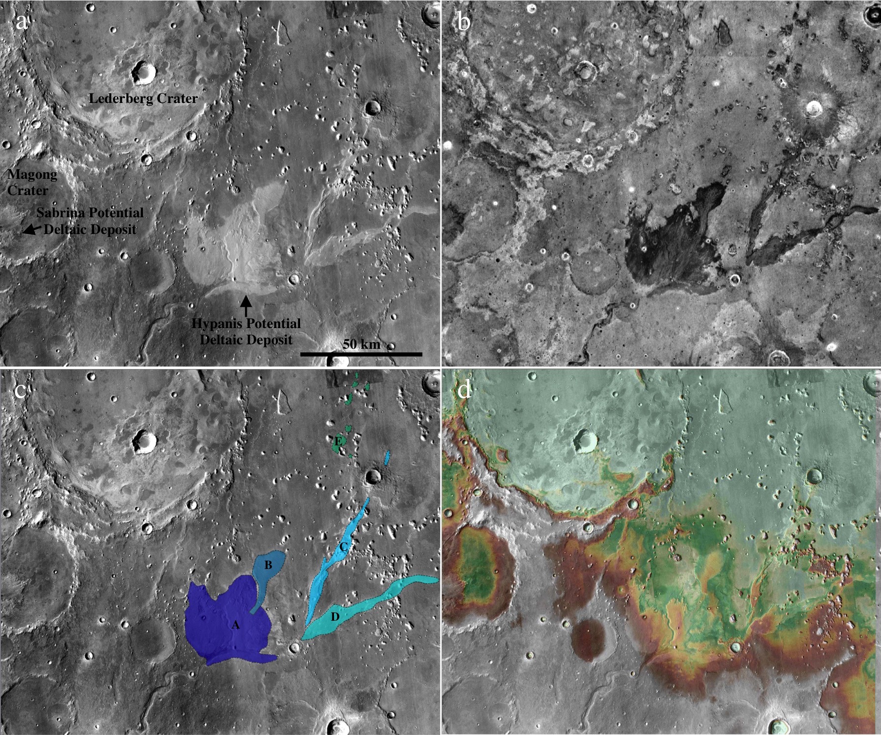
Ancient river deltas are found in many locations on Mars [see Di Achile & Hynek, 2010 and references therein], and are formed as sediment drops out of suspension in water as it approaches a wider shoreline of a lake, sea, or (debatably) an ocean. Some proposed deltas on Mars are found in closed basins (e.g. an impact crater) away from the Martian dichotomy boundary, implying an ancient climate during which the crater ponded with water [e.g. Eberswalde or Jezero]. Occasionally, inlet and outlet river valleys are seen at different elevations along the crater rim, lending further evidence to the hypothesis that the crater filled with liquid water at least up to the outlet elevation. Deltas found in open basins, on the other hand, imply a larger body of standing water, and Mars scientists look for other clues to support the deltaic rather than alluvial fan formation mechanism. In our recent papers, we tested whether the Hypanis fan-shaped deposit (Image 1) could be a delta, and discussed whether this supports the hypothesis that there was once a large sea or ocean in the Northern plains of Mars [Adler et al., 2018; Fawdon et al., 2018].
Image 1: a) The Hypanis deposit stands out as light-toned in the center of this Mars Reconnaissance Orbiter (MRO) Context Camera (CTX) mosaic of our study region. Also marked are Lederberg crater, and the Sabrina deposit in the closed basin of Magong crater. (b) Hypanis and Sabrina have a low nighttime temperature (dark) as recorded by the THEMIS instrument on Mars Odyssey, suggesting it is mostly composed of small grain size material. Image from the Nighttime IR 100m Global Mosaic v14.0 [Hill et al. (2014); Edwards (2011)] and from the Northern Hypanis Valles Night IR Mosaic [Fergason (2009)]. NASA/JPL/ASU. (c) Our proposed fluvial sequence discussed in the paper. Main lobe (A) could once have had continuous layered beds spanning to the distal island deposits (E). The cross-cutting relationships we observed are consistent with hypothesized shoreline regression to the north. Flow migrated to the northern lobe (B), then to braided inverted channels (C and D) as water retreated. NASA/MSSS/USGS. d) Our digital elevation mosaic shows the topography of Hypanis and surrounding features. Elevations are colored from white (-2500 m) to light green (-2800 m).
Post by Dr. Ryan B. Anderson, Astrogeology Science Center, United States Geological Survey
One of the most environmentally diagnostic features of sedimentary rocks is cross-bedding, which occurs when sediment is transported by wind, water, or volcanic processes, resulting in horizontal strata composed of inclined beds. The geometry of cross-bedded sedimentary deposits provides information about the depositional setting and post-depositional history of the rocks, making the identification, measurement, and interpretation of cross-beds particularly interesting on Mars, where past conditions are of great scientific interest. This post describes cross-bedding in Upper Aeolis Mons in Gale crater (Image 1).
Image 1: Example of complex bedding patterns in upper Aeolis Mons, interpreted to be large-scale aeolian cross beds. Image is an inset of HiRISE observation PSP_001620_1750.
Post by Peter Grindrod, Natural History Museum, London, UK.
A number of different studies have catalogued features on Mars that could be given the general heading of sedimentary fans [e.g. Irwin et al., 2005; Kraal et al. 2008]. These features occur whenever the velocity of a river or stream decreases, and the water no longer has enough energy to carry its sediment, and thus begins to deposit its load. This drop in energy often occurs when the water flows into flatter and wider regions. The distribution of these fans on Mars is important because it shows the location of past water flows, and the amount of material that has been transported (which can be used as a proxy for flow duration).
However, one of the fundamental problems when looking at these features with orbital data alone, is that it is difficult to determine whether the river flowed into a standing body of water (for example a lake) or just an empty canyon or crater. Of course, the implications of this problem are important if we want to understand the volume and distribution of past water on Mars, which in themselves feed into understanding the past climate and even habitability of Mars.
Image 1: Location of the two fans in Coprates Catena, SE Valles Marineris. MOLA elevation overlain on THEMIS daytime image.
Thousands of putative debris-covered glaciers in Mars’ middle latitudes host water ice in volumes comparable to that of all glaciers and ice caps on Earth, excluding the Greenland and Antarctic ice sheets (Levy et al., 2014). These glaciers formed within the last 100 million to 1 billion years of Mars’ geological history (Berman et al., 2015), a period that is thought to have been similarly cold and hyper-arid to present-day Mars. This is broadly corroborated by a sparsity of evidence for melting of these geologically ‘young’ mid-latitude glaciers, which suggests that they have always been entirely frozen to their beds in ‘cold-based’ thermal regimes, and haven’t generated meltwater (e.g. Marchant and Head, 2007). Nevertheless, this months’ planetary geomorphology image provides evidence for melting of one such glacier.
Image 1: An esker emerging from the tongue of a debris-covered glacier in Tempe Terra, Mars. See Image 2 for an annotated 3D view of this scene. The dashed white line delineates the terminus of the debris-covered glacier, which occupies the southern and eastern portions of the image. The white arrow marked A indicates the first emergence of the crest of the esker ridge from the glacier surface. The white arrow marked A’ indicates the northernmost end of the esker ridge in the deglaciated zone beyond the ice terminus. Context Camera image P05_002907_2258_XN_45N083W (Malin et al., 2007). Modified from Butcher et al., 2017 under a Creative Commons license CC BY 4.0.
Post by Laura Brooker, Open University, Milton Keynes, UK.
Polygonal ground of centimetre- to decametre-scale is one of the most common features found in cold-climate regions on Earth and on Mars. Polygonal shapes on Earth can form through a number of different processes including the thermal contraction of ice-cemented soils, forming fracture patterns known as thermal contraction polygons, through the freezing and thawing of ground ice moving clasts, in the case of sorted patterned ground, or through the dehydration of volatile-rich material, termed desiccation polygons. Around a large crater found in the northern latitudes of Mars, named Lyot, we observe stunning and unusually large clastic polygons (Image 1), but how do they form? To understand landforms on Mars we turn to analogues on Earth and compare morphological data to look for similarities and differences.
Image 1: HiRISE (ESP_016985_2315) image of clastic polygonal ground observed to the north east of Lyot crater, Mars. These enigmatic polygons are demarcated by clastic material in their borders and are averagely 130 metres in diameter. Image credit: NASA/JPL/University of Arizona.
Post contributed by Andreas Johnsson, Department of Earth Sciences, University of Gothenburg, Sweden.
Small-scale lobes on Mars (Fig. 1) are tens to hundreds of meters wide and consist of an arcuate frontal riser that is a meter to meters in height and a tread surface (Johnsson et al., 2012) (Fig. 2). The riser is often, but not always, outlined by clasts visible at HiRISE resolution (50-25 cm/pixel; McEwen et al., 2007). They are found on crater slopes in the martian middle and high latitudes in both hemispheres (e.g., Gallagher et al., 2011; Johnsson et al., 2012; 2017) .
Figure 1. Subset of HiRISE image PSP_008141_2440 (lat: 63.78°N/long: 292.32°E) showing multiple clast-banked lobes in an unnamed 16-km diameter crater (white arrow). Note the degraded gully system (black arrows) and lobes inside the alcove area.
Post contributed by Susan J. Conway and Anthony Guimpier, CNRS Laboratoire de Planétologie et Géodynamique à Nantes, France.
Landslides have been documented on almost all the solid bodies of the solar system and Mars is no exception. The most famous landslides on Mars are the giant landslides in the Valles Marineris, which were discovered in the images returned by the first Mars Orbiter “Mariner 9” launched in 1971 (Lucchitta, 1979). They have volumes typically ranging from 108-1013 m3 (McEwen 1989; Quentin et al. 2004; Brunetti et al. 2014) and have been found to have occurred periodically since the canyon’s formation 3.5 billion years ago (Quantin et al. 2004). The largest size of terrestrial landslides generally only extends to 108 m3 (McEwen 1989; Quentin et al. 2004).
Image 1: Oblique views of small landslides on Mars. Top: Landslide in Chyrse Choas in HiRISE image PSP_005701_1920 draped over 2 m/pix elevation model. Crater just in front of the landslide is 70 m in diameter and the landslide from crest to toe spans 900 m in elevation. The largest boulders are nearly 40 m in diameter. Bottom: Landslide in Capri Chasma in HiRISE image ESP_035831_1760 draped over 2 m/pix elevation model. Crater on slope is 270 m across and the landslide from crest to toe spans ~1 km of elevation. The largest boulders are just over 30 m in diameter.
Post contributed by A.M. Bramson, Lunar and Planetary Laboratory, University of Arizona
When an object impacts into layered material, it can form a crater with terraces in the crater’s walls at the layer boundaries, rather than the simple bowl-shape that is expected. The shock wave generated by the impact can more easily move the weaker material and so the crater is essentially wider in that layer, and smaller in the underlying stronger material. From overhead, these concentric terraces give the appearance of a bullseye. Craters with this morphology were noticed on the moon back in the 1960s with the terracing attributed to a surface regolith layer. More recently, numerous terraced craters have been found across a region of Mars called Arcadia Planitia that we think is due to a widespread buried ice sheet.
Image 1: A terraced crater with diameter of 734 meters located at 46.58°N, 194.85°E, in the Arcadia Planitia region of Mars. This 3D perspective was made by Ali Bramson with HiRISE Digital Terrain Model DTEEC_018522_2270_019010_2270_A01. Using this 3D model, we were able to measure the depth to the terraces, and therefore the thicknesses of the subsurface layers that cause the terracing.
Post by Dr. T. de Haas, Department of Geography, Durham University.
Martian gullies are composite landforms that comprise an alcove, channel and depositional fan. They are very young geological features, some of which have been active over the last million years. Water-free sediment flows, likely triggered by CO2 sublimation, debris flows, and fluvial flows have all been hypothesized to have formed gullies. These processes require very different amounts of liquid water, and therefore their relative contribution to gully-formation is of key importance for climatic inferences. Formative inferences based on surface morphology may be biased however, because of substantial post-depositional modification (Images 1-3).
Image 1: Morphometry, morphology and stratigraphy of depositional landforms in Galap crater. (a) Overview and digital elevation model of Galap crater. (b) Detail of northwestern slope showing gradients of catchment and depositional fan. (c) Detail of proximal fan surface. (d) Detail of distal fan surface. (e) Detail of fan surface with incised channels; the dashed line indicates the rockfall limit. (f) Example of stratigraphic section. (h) Same stratigraphic section as in f, but with optimized contrast in the section. Arrows denote downslope direction. HiRISE image PSP_003939_1420.
Post contributed by Dr. Petr Brož, Institute of Geophysics of the Czech Academy of Science
Volcanism is an important process which shapes the surfaces of all terrestrial planets, and is still active on Earth, Jupiter’s moon Io, and perhaps on Venus. On Earth, volcanoes with wide variety of shapes and sizes exist; however, the size of volcanoes is anti-correlated with their frequency, i.e. small volcanoes are much more numerous than large ones. The most common terrestrial volcanoes are represented by kilometre-sized scoria cones (Figure 1a). These are conical edifices of pyroclastic material originating from explosive volcanic activity. Degassing of ascending magma causes magma fragmentation on eruption piling up the pyroclasts around the vent as a cone. Interestingly, scoria cones as known from Earth, have not been observed commonly on any other terrestrial body in the solar system despite the fact that magma degassing, and hence magma fragmentation, has to occur on these bodies as well.
Figure 1: Example of a terrestrial scoria cone (panel a, Lassen Volcanic National Park, California, photographed by the National Park Service) and its putative martian analogue (panel b, detail of CTX image P22_009554_1858_XN_05N122W).
Post by Dr. Alexis Rodriguez. Planetary Scientist, Planetary Science Institute, Tucson, AZ, USA.
The Martian northern lowlands are thought to currently be extensively covered by an ice-rich deposit, interpreted by some researchers to be the residue of an ancient ocean that existed ~3.4 Ga (Kreslavsky and Head., 2002). However, evidence for this ocean has remained a subject of intense dispute and scientific scrutiny since it was first proposed (Parker et al., 1989, 1993) several decades. The controversy has largely stemmed in the fact that the proposed Martian paleo-shoreline features exhibit significant elevation ranges (Head et al., 1999), a lack of wave-cut paleoshoreline features (Malin and Edgett, 1999), and the presence of lobate margins (Tanaka et al., 1997, 2005).
Fig. 1. Left: Color-coded digital elevation model of the study area showing the two proposed shoreline levels of an early Mars ocean that existed approximately 3.4 billion years ago. Right: Areas covered by the documented tsunami events extending from these shorelines. Lead author Alexis Rodriguez created this figure.
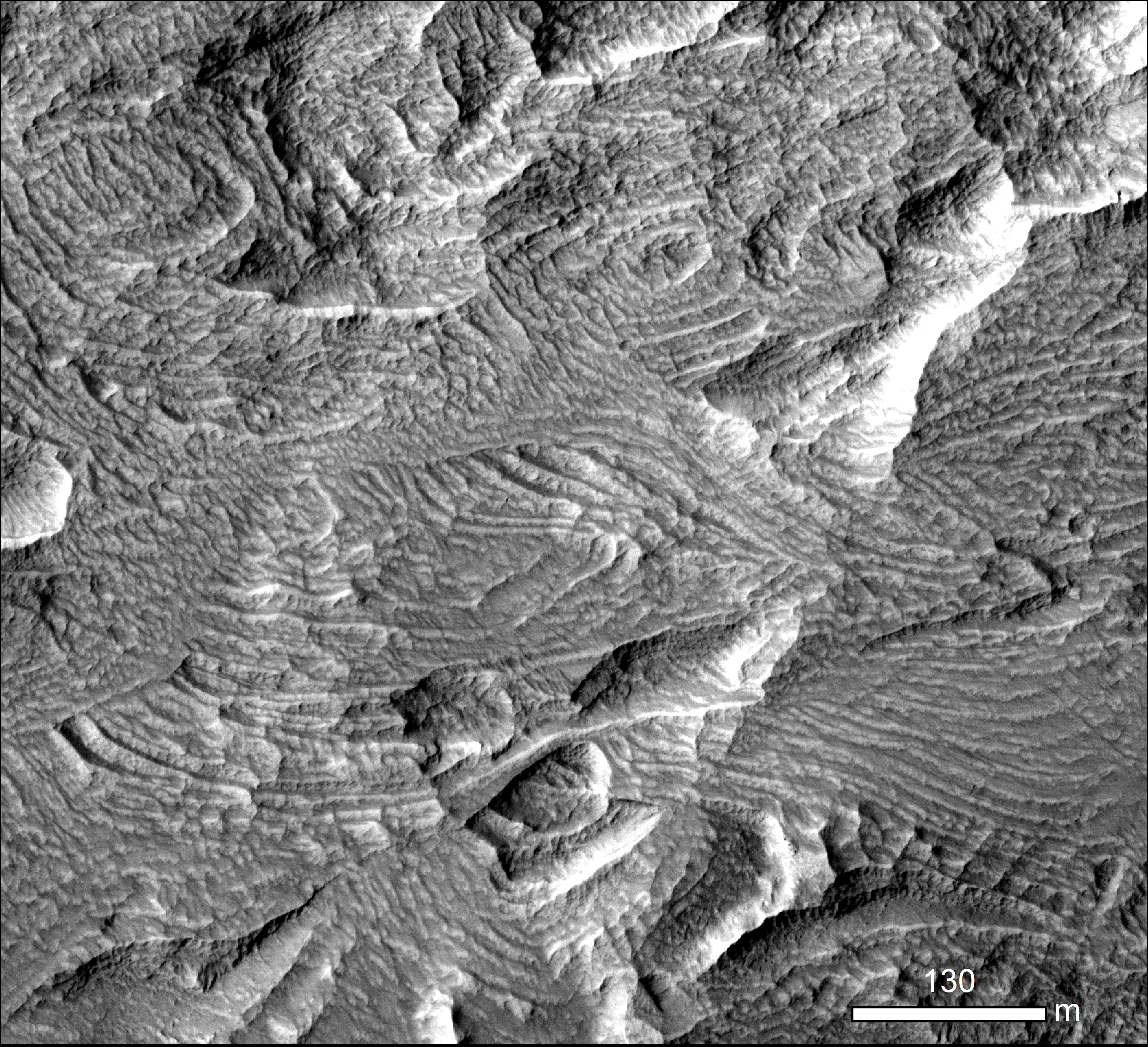
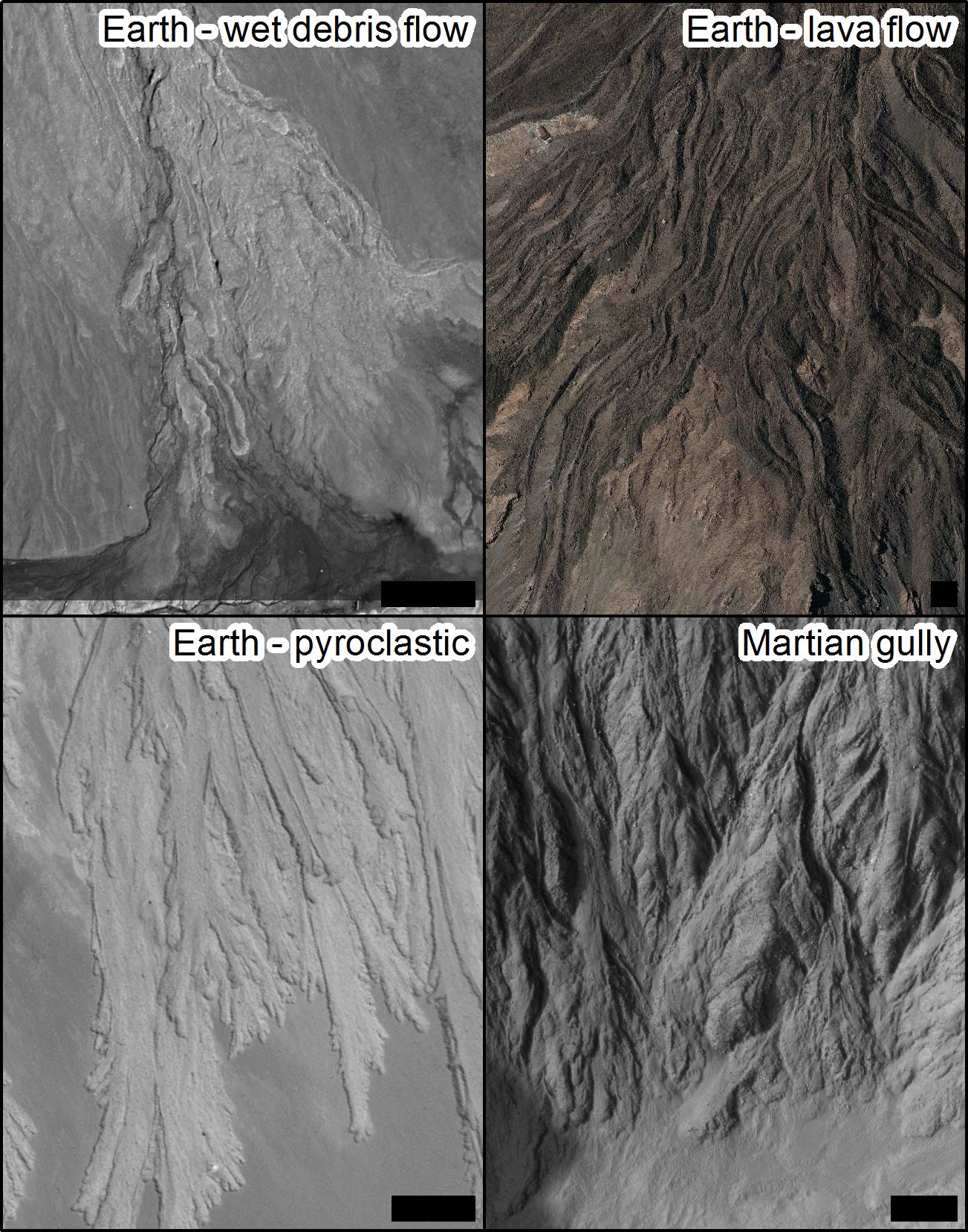
The similarity of water-formed landforms on Earth is often used as a key argument for the involvement of liquid water in shaping the surfaces of other planets. The major drawback of the argument is “equifinality” whereby very similar looking landforms can be produced by entirely different processes. A good illustration is leveed channels with lobate deposits (Image 1). Such landforms can be built on Earth by wet debris flow, lava flow, pyroclastic flows and they are also found on Mars (de Haas et al., 2015; Johnsson et al., 2014) where the formation process is debated.
Image 1: Lobes and levees, scale bars are 50 m in all cases. Wet debris flow deposits in Svalbard, image credit DLR HRSC-AX campaign. Lava flows on Tenerife, aerial image courtesy of IGN, Plan Nacional de Ortofotografía Aérea de España. Self-channelling pyroclastic deposits at Lascar volcano, Chile, Pleiades image. Depositional lobes in Istok crater on Mars, HiRISE image PSP_007127_1345.
Post contributed by Dr. Ryan C. Ewing, Department of Geology and Geophysics, Texas A&M University
Ripples cover the surfaces of sand dunes on Earth and Mars. On Earth, ripples formed in typical aeolian sand (e.g., 0.1 and 0.3 mm) range in wavelength between 10 and 15 cm and display a highly straight, two-dimensional crestline geometry. Ripples are thought to develop through a process dominated by the ballistic impacts of saltating sand grains in which wavelength selection occurs through the interplay of grain size, wind speed, the saltation trajectories of the sand grains, and ripple topography.
Figure 1: Wind-blown impact ripples from Mesquite Flat Sand Dunes, Death Valley, USA. Pen is ~15 cm. Inferred transport direction is to the right on the image. Image credit: Ryan C. Ewing


