Grabens, evidence for widespread recent tectonism on Mercury

Post contributed by Ben Man, The Open University @AstroBenjamin

Mercury is a contracting world as evidenced by the abundance of shortening structures observed across the surface of the planet (Image 1). Global contraction as a result of secular cooling of the planetary interior is most likely responsible for widespread compressional tectonism with shortening structures seen cutting all surface materials at all latitudes and longitudes. Shortening structures are accepted as the surface manifestation of thrust faults and folding. Grabens, such as those observed in the images (Image 1-3), are secondary structures found on top of parent shortening structures. The presence of these grabens provide evidence for recent widespread tectonism on Mercury, confirming that global contraction is ongoing.

Image 1: Aspect view of Alpha Crucis Rūpes with horst and grabens present in the foreground of the image. Alpha Crucis Rūpes is located in H09 Eminescu, an equatorial quadrangle. The image is comprised of the H09 south east high incidence west mosaic tile and five individual narrow-angle camera frames (EN0231136925M, EN0231136927M, EN0231136960M, EN0231136962M, EN0231136998M). The image has not been vertically exaggerated and the scale bar is computed for the centre of the image. Image source: NASA/JHUAPL/CIW made by Benjamin Man. Image frames and mosaic tiles are available from NASA’s Planetary Data System Geosciences Node (https://pds-geosciences.wustl.edu/) and the Cartography and Imaging Sciences Node (https://pds-imaging.jpl.nasa.gov/).

(more…)
Slope Deformation Associated with Recent Tectonism in Taurus-Littrow Valley, Apollo 17 Landing Site

Post contributed by Giulia Magnarini, Natural History Museum of London @Magna_Giulia

The availability of high-resolution images provided by the Narrow Angle Camera, on board of the Lunar Reconnaissance Orbiter, has enabled the study of recent and active surface processes on the Moon by revealing geological and geomorphological features with unprecedented details. Of the many locations on the Moon where recent geological structures have been identified, Taurus-Littrow Valley (Image 1) is one of the most interesting. Indeed, it was also selected as the Apollo 17 landing site because of its complex geology.

Image 1: Oblique view of the South Massif in Taurus-Littrow valley, on the Moon.

(more…)

Geological and topographical analysis of Anshar Sulcus, Ganymede: Implications for grooved terrain formation

Post contributed by Dr. Mafalda Ianiri, University G. d’Annunzio Chieti- Pescara, International Research School of Planetary Sciences.

The icy surface of Ganymede, the largest satellite of the Jupiter system, presents two dominant terrains characterized by different albedo: the dark and light terrains (Image 1). The dark terrains are composed of dark, albedo-heterogeneous material, modified by surficial processes, such as sublimation, mass wasting, and sputtering (ejection and redistribution of molecules across the Ganymede’s surface, which is caused by the energy transferred to the surface through the impact of particles from Jupiter’s magnetosphere; Pappalardo et al., 2004). The dark terrains are highly cratered, preserving the relicts of vast global-scale sets of concentrically arranged structures, called furrows (Pappalardo et al., 2004). The younger light terrains are more extensive than the dark terrains, covering approximately 64% of Ganymede’s surface (Patterson et al., 2010). Light terrains are pervasively crossed by sets of sub-parallel, closely spaced ridges and troughs, referred to as grooves (Patterson et al., 2010; Pappalardo et al., 2004).

Image 1: Geomorphological map of Anshar Sulcus region of Ganymede based on the 2865_r and 2878_r high resolution images captured by Galileo SSI camera. (Credit: Ianiri et al., 2023).

(more…)

BepiColombo: the challenge is at dawn

Post contributed by Dr Valentina Galluzzi – National Institute of Astrophysics, Institute for Space Astrophysics and Planetology (INAF-IAPS), Italy.

The ESA/JAXA BepiColombo spacecraft is on a long journey into orbit around Mercury. This journey includes six flybys of the planet before orbital insertion in 2025. On 23 June 2022, BepiColombo accomplished its second flyby of Mercury by approaching the planet as close as 200 km from the surface. Unfortunately, this happened when night shadows were still hiding the surface from sight. It was just 5 minutes after closest approach that the Monitoring Cameras (M-CAMs, three in total) mounted on the BepiColombo’s Mercury Transfer Module (MTM) could start taking the first snapshots of the planet with enough light. This caused the pictures to show dramatic sunrise shadows along the terminator. One of the first regions to be imaged was the Eminescu area of Mercury, as seen in Image 1.

Image 1: Composite image of the Eminescu region of Mercury made with BepiColombo/MTM M-CAM#2 “Image 02” taken during BepiColombo’s second Mercury flyby (credits: ESA) overlain by MESSENGER/MDIS enhanced colors (Denevi et al., 2018). Some spacecraft parts are visible near the frame margins. North is to the left. For scale reference, Izquierdo crater diameter is about 150 km (see Image 2).

In this picture, the shadow-enhanced morphology comes from the original M-CAM#2 frame taken at 09:24 UTC. By georeferencing the original M-CAM photo onto the Mercury’s spatial frame (Galluzzi et al., 2022) it was possible to overlay terrain color using the MESSENGER/MDIS enhanced color mosaic (Denevi et al., 2018). The composite image helps to highlight the terrain diversity in this area, from the yellowish young smooth plains to the dark blue and rougher intercrater plains.

(more…)

New Images of Europa from Juno’s JunoCam

Post contributed by Dr Candice J. Hansen, Planetary Science Institute, USA

On the 29th of September 2022 the Juno spacecraft, in orbit around Jupiter, made a close pass by Jupiter’s icy moon Europa (Image 1). The spacecraft approached from Europa’s night side, passed the terminator (day-night boundary), and departed on the day side, coming within ~350 km of the surface.  Juno’s visible color imager, JunoCam, snapped 4 images of Europa as the spacecraft sped by at a speed of 23.6 km/sec on its way to its closest approach to Jupiter.  In an elliptical polar orbit, this was the only opportunity in the mission for Juno to get close to this moon of Jupiter and the first time since the Galileo mission ended in 2003 that any spacecraft has flown so close. 

Image 1.  The first image taken by JunoCam is centered on the subjovian hemisphere, extending to ~60 deg north and south.  This was the highest resolution image acquired. Image data: NASA/JPL-Caltech/SwRI/MSSS. Image processing: Brian Swift © CC BY.

Europa is categorized as an “ocean world” with a solid ice surface over a liquid water subsurface layer.  Europa is crisscrossed by numerous cracks, bands, ridges and troughs (lineaments) that record the tidal stress the moon experiences arising from the gravitational pull of Jupiter and its other moons. JunoCam’s image reveals numerous pits along the terminator.  The almost complete lack of craters tells us that geologically this icy surface is very young, resurfaced by lineament formation due to tidal flexing.  Callanish crater, one of the few imaged by JunoCam, is the circular feature visible in the lower right of Image 1.  

(more…)

Syn-tectonic Sedimentation in Valles Marineris, Mars

Post contributed by Dr Joel Davis, Department of Earth Sciences, Natural History Museum, UK

On Earth, the interplay between tectonics and sedimentation is commonplace. In regions such as Death Valley, USA, extensional tectonic processes have formed sedimentary basins, where the subsequent erosion of the landscape causes the formation of features such as alluvial fans. Alluvial fans are conical-shaped, sedimentary deposits usually formed by stream flows in upland regions. Later tectonic activity can lead to the deformation and relative uplift of these landforms. A new generation of alluvial fans may then form, overprinting the older generation and extending down to the new position of the basin floor.

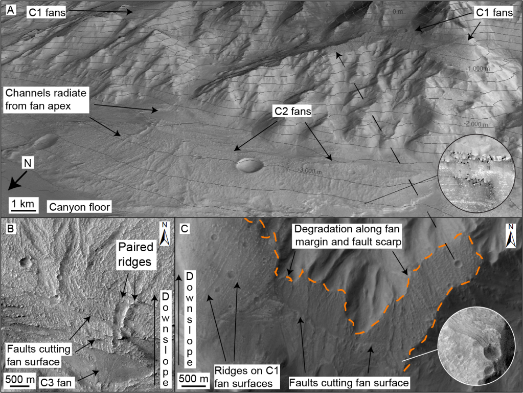
To contrast, as most alluvial fans on Mars are found within impact craters, they do not show evidence of tectonic deformation. The alluvial fans hosted within the canyons of Valles Marineris appear to be an exception to this (Figure 1). Valles Marineris may have developed over billions of years by repeated episodes of normal faulting. In several regions of Valles Marineris, not only are alluvial fans found on the current floor, but remnants of such features are found on the canyon walls as well – perched several kilometres above the floor!

Figure 1: Faulted alluvial fan deposits in Coprates Chasma, Mars. (A) Oblique Context Camera (CTX) image of multiple generations of alluvial fan deposits, offset by faulting. Credit: NASA/JPL/MSSS. Inset shows High Resolution Imaging Science Experiment (HiRISE) image of bright-toned layering in fan margins. Topographic contour interval is 200 m. Credit: NASA/JPL/UoA. (B) HiRISE mosaic of C2 alluvial fan deposits on canyon floor, where surfaces contain distributary channels and paired ridges, cut by multiple faults. Youngest C3 fans superpose faults and are local to C2 fan apices. Credit: NASA/JPL/UoA. (C) Planform CTX mosaic of oldest (C1) alluvial fan deposits (perched terraces), which have been faulted and later eroded (orange line). NASA/JPL/MSSS. After Davis et al., 2021.

(more…)

Jostling Pack Ice(ish) on Venus

Post contributed by Prof. Paul K. Byrne, Department of Earth and Planetary Science, Washington University in St. Louis, USA.

Venus is a tectonically tortured world (Image 1). Vast rift systems, widespread crustal shortening, and a crumpled terrain type, tessera, collectively attest to major tectonic activity on a world only a little smaller than Earth. In places, strains are spatially distributed; in others, extension or shortening is concentrated into narrow bands. And, where these bands intersect, they define a type of tectonic deformation on Venus that hasn’t been recognised before.

Image 1: A 1,100 km-wide, false-colour radar view of Lavinia Planitia, one of the lowland regions on Venus where the lithosphere has fragmented into blocks (purple) delineated by belts of tectonic structures (yellow). Image credit: Paul K. Byrne.

(more…)

Ridged Plains on Europa Reveal a Compressive Past

Post Contributed by Dr. Erin Leonard, Postdoctoral Fellow at the Jet Propulsion Laboratory, California Institute of Technology

Jupiter’s icy moon Europa has a geologically young surface (60-100 million years old), as evidenced by the sparsity of large impact craters. Studying the surface features on Europa allows insight into how resurfacing may have given it a youthful appearance. The majority of Europa’s young surface is made up of Ridged Plains terrain. This terrain has not been extensively studied before because it appears as a smooth and relatively bland in the global-scale images. However, in the few high-resolution images returned by the Galileo mission in the early 2000s, the Ridged Plains are revealed to consist of numerous ridges and troughs that have a range of morphologies—from crisscrossing each other in various directions to orderly sets of parallel structures (Image 1). But how did these ridges and troughs form?

LeonardFigure1

Image 1: A variety of examples of ridged plains on Europa. Note the linear to curvilinear systematic ridge traces in all examples: (A) observation E4ESDRKMAT02 at 26 m/pixel, (B) observation 19ESRHADAM01 at 66 m/pixel, (C) observation 12ESWEDGE_02 at 29 m/pixel, and (D) observation 12ESMOTTLE02 at 16 m/pixel.

(more…)

Valley Networks on Venus

Posted by Dr. Goro Komatsu, IRSPS, Univ. G.d’Annunzio, Italy.  

(Re-posted from IAG Image of the Month, December, 2007)

“…excitement and pleasure in science derive not so much from achieving the final explanation as from discovering the fascinating range of new phenomena to be explained” (Baker and Komatsu, 1999).”

Networks on Venus

The Magellan spacecraft acquired SAR (Synthetic Aperture Radar) images of venusian surfaces at a spatial resolution range of about 100 m per pixel.

(more…)

Vir-Ava Chasma, Venus

Posted by Les Bleamaster, Planetary Science Institute, Tucson, Arizona, USA.

(Re-posted from IAG Image of the month, July 2007)

This false color, three-dimensional perspective view over the Turan Planum of Venus shows the interaction of tectonic structures and volcanic processes along chasmata or “rifts.”

venus

Foreground is approximately 400 km, with a vertical exaggeration of 8x.

(more…)

  • Enter your email address to follow this blog and receive notifications of new posts by email.

  • Io

  • Blog Stats

    • 192,898 hits