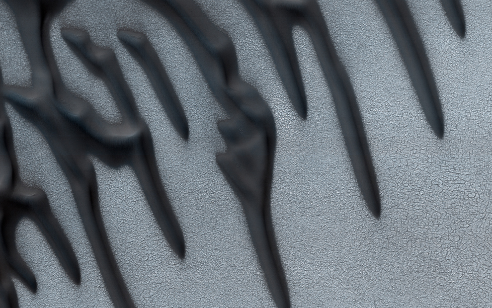
Creepy stuff – possible solifluction on Mars

Post contributed by Andreas Johnsson, Department of Earth Sciences, University of Gothenburg, Sweden.

Small-scale lobes on Mars (Fig. 1) are tens to hundreds of meters wide and consist of an arcuate frontal riser that is a meter to meters in height and a tread surface (Johnsson et al., 2012) (Fig. 2). The riser is often, but not always, outlined by clasts visible at HiRISE resolution (50-25 cm/pixel; McEwen et al., 2007). They are found on crater slopes in the martian middle and high latitudes in both hemispheres (e.g., Gallagher et al., 2011; Johnsson et al., 2012; 2017) .

Figure 1

Figure 1. Subset of HiRISE image PSP_008141_2440 (lat: 63.78°N/long: 292.32°E) showing multiple clast-banked lobes in an unnamed 16-km diameter crater (white arrow). Note the degraded gully system (black arrows) and lobes inside the alcove area.

(more…)

Small martian landslides – are they similar to large landslides on Earth?

Post contributed by Susan J. Conway and Anthony Guimpier, CNRS Laboratoire de Planétologie et Géodynamique à Nantes, France.

Landslides have been documented on almost all the solid bodies of the solar system and Mars is no exception. The most famous landslides on Mars are the giant landslides in the Valles Marineris, which were discovered in the images returned by the first Mars Orbiter “Mariner 9” launched in 1971 (Lucchitta, 1979). They have volumes typically ranging from 108-1013 m3 (McEwen 1989; Quentin et al. 2004; Brunetti et al. 2014) and have been found to have occurred periodically since the canyon’s formation 3.5 billion years ago (Quantin et al. 2004). The largest size of terrestrial landslides generally only extends to 108 m3 (McEwen 1989; Quentin et al. 2004).

bothLandslides3d

Image 1: Oblique views of small landslides on Mars. Top: Landslide in Chyrse Choas in HiRISE image PSP_005701_1920 draped over 2 m/pix elevation model. Crater just in front of the landslide is 70 m in diameter and the landslide from crest to toe spans 900 m in elevation. The largest boulders are nearly 40 m in diameter. Bottom: Landslide in Capri Chasma in HiRISE image ESP_035831_1760 draped over 2 m/pix elevation model. Crater on slope is 270 m across and the landslide from crest to toe spans ~1 km of elevation. The largest boulders are just over 30 m in diameter.

(more…)

Terraced Craters Reveal Buried Ice Sheet on Mars

Post contributed by A.M. Bramson, Lunar and Planetary Laboratory, University of Arizona

When an object impacts into layered material, it can form a crater with terraces in the crater’s walls at the layer boundaries, rather than the simple bowl-shape that is expected. The shock wave generated by the impact can more easily move the weaker material and so the crater is essentially wider in that layer, and smaller in the underlying stronger material. From overhead, these concentric terraces give the appearance of a bullseye. Craters with this morphology were noticed on the moon back in the 1960s with the terracing attributed to a surface regolith layer. More recently, numerous terraced craters have been found across a region of Mars called Arcadia Planitia that we think is due to a widespread buried ice sheet.


Bramson_IAG_1
Image 1: A terraced crater with diameter of 734 meters located at 46.58°N, 194.85°E, in the Arcadia Planitia region of Mars. This 3D perspective was made by Ali Bramson with HiRISE Digital Terrain Model DTEEC_018522_2270_019010_2270_A01. Using this 3D model, we were able to measure the depth to the terraces, and therefore the thicknesses of the subsurface layers that cause the terracing.

(more…)

The subsurface as the key to surface on Martian gullies

Post by Dr. T. de Haas, Department of Geography, Durham University.

Martian gullies are composite landforms that comprise an alcove, channel and depositional fan. They are very young geological features, some of which have been active over the last million years. Water-free sediment flows, likely triggered by CO2 sublimation, debris flows, and fluvial flows have all been hypothesized to have formed gullies. These processes require very different amounts of liquid water, and therefore their relative contribution to gully-formation is of key importance for climatic inferences. Formative inferences based on surface morphology may be biased however, because of substantial post-depositional modification (Images 1-3).

Image1

Image 1: Morphometry, morphology and stratigraphy of depositional landforms in Galap crater. (a) Overview and digital elevation model of Galap crater. (b) Detail of northwestern slope showing gradients of catchment and depositional fan. (c) Detail of proximal fan surface. (d) Detail of distal fan surface. (e) Detail of fan surface with incised channels; the dashed line indicates the rockfall limit. (f) Example of stratigraphic section. (h) Same stratigraphic section as in f, but with optimized contrast in the section. Arrows denote downslope direction. HiRISE image PSP_003939_1420.

(more…)

It is Mercury’s fault(s)…

Post contributed by Valentina Galluzzi, INAF, Istituto di Astrofisica e Planetologia Spaziali (IAPS), Rome, Italy

Any celestial body that possesses a rigid crust, be it made of rock (e.g. terrestrial planets, asteroids) or ice (e.g. icy satellites), is subject to both endogenic and exogenic forces that cause the deformation of crustal materials. As a result of the mass movement, the brittle layers often break and slide along “planes” commonly known as faults. In particular, tensional, compressional and shear forces form normal, reverse and strike-slip faults, respectively. On Earth, plate tectonics is the main source of these stresses, being a balanced process that causes the lithospheric plates to diverge, converge and slide with respect to each other. On Mercury, there are no plates and therefore the tectonics work differently. Instead its surface is dominated by widespread lobate scarps, which are the surface expression of contractional thrust faults (i.e. reverse faults whose dip angle is less than 45°) and this small planet is in a state of global contraction.

image1

Image 1. Endeavour Rupes area on Mercury, image is centred at 37.5°N, 31.7°W. Top: MESSENGER MDIS High-Incidence angle basemap illuminated from the West (HIW) at 166 m/pixel. Bottom: MESSENGER global DEM v2 with a 665m grid [USGS Astrogeology Science Center] on HIW basemap, the purple to brown colour ramp represents low to high elevations, respectively. Endeavour Rupes scarp is high ~500 m. For scale, Holbein crater diameter is approximately 110 km.

(more…)

Mars Dunes

Posted by Mary Bourke, Geography, Trinity College, Dublin, Ireland.

(Re-posted from IAG Image of the Month, June, 2007)

Both Earth and Mars have atmospheres that can mobilize particles to form sand dunes. This image is from the caldera of an inactive Volcano (Nili Patera) on Mars. The steep avalanche face on the downwind side of the dunes indicates wind direction (see arrow). There are several types of sand dunes in this image, some of which have not been previously recognized on Mars. (more…)

  • Enter your email address to follow this blog and receive notifications of new posts by email.

  • Io

  • Blog Stats

    • 192,914 hits