Post contributed by Noé Le Becq, PhD candidate, Laboratoire de Planétologie et Géosciences, Nantes (France)
Ceres was discovered in 1801 by Giuseppe Piazzi and is located in the main asteroid belt between the orbits of Mars and Jupiter. In the mid-2000s, Hubble Space Telescope observations revealed that Ceres was ice-rich (McCord and Sotin, 2005), making it the closest icy world to Earth! Therefore, the NASA Dawn spacecraft explored it between 2015 and 2018, unveiling a dwarf planet with a crust made of a mixture of ice and rocks (Ermakov et al., 2017), and a complex surface showing signs of recent or possibly ongoing geological activity (Zambon et al., 2017; Scully et al., 2019). The absence of atmosphere makes water ice unstable when exposed to Ceres’ surface. Yet sublimation of the ice contained in the crust could be at the origin of certain morphologies observed (Sizemore et al., 2019), and could more specifically have an important role in the degradation of impact craters over time (Image 1A). After an impact, the freshly exposed ice-rich material on the crater walls sublimates, leading to its fragmentation and the formation of large talus deposits underneath (Image 1B). This is an important process in the evolution of the topography of impact craters on Ceres, very different to what is observed on rocky moons and planets of the inner Solar System.
Image 1: On the left, Ceres as seen by the NASA Dawn spacecraft during its approach in 2015. Occator crater, shown in 3D on panel A, is one of the youngest craters at the surface of Ceres and has large talus deposits along its walls. Panel B is a zoomed 3D view (with no vertical exaggeration) of the North-eastern wall of Occator crater, where the talus can be observed. Ceres approach image (PIA19558) and Occator 3D view (PIA21913) are from NASA/JPL-Caltech/UCLA/MPS/DLR/IDA.
Post contributed by Alistair Blance, The Open University, UK
During an impact on Mercury’s surface, material is ejected from the forming impact crater. As Mercury has only a tenuous atmosphere, ejected material travels predominantly ballistically, creating an ejecta deposit around the crater that thins gradually with increasing distance. However, large deposits emplaced by ground-hugging flows can be found around some impact craters on Mercury (Image 1). Evidence for flow includes material being diverted around obstacles, a steep edge or distal ridge at deposit margins, and a lobate shape to several examples. Some flow deposits extend outwards around a whole crater, but often they are confined within topographic lows adjacent to the crater. To help assess the origin of these features, it is useful to compare them to similar features across the Solar System. This comparison may also indicate how differences between the planets can influence the development of flows around craters.
Image 1: Flow deposits around craters on Mercury. Deposit boundaries indicated with red triangles. (A) Flow deposit extending from the central crater into an underlying crater in the top right of the image. Steep margins with a lobate shape suggest emplacement by flow. Image taken from MESSENGER MDIS BDR Global Basemap. (B) A crater with two sections of flow deposit extending into the underlying crater in the bottom right of the image. Image taken from MESSENGER MDIS frame EW0260906588G. (C) Sketch map of the image in B. Shows the two sections of flow deposit in red, with hypothesised direction of emplacement shown with red arrows. The deposit appears to have been diverted around a central peak within the underlying crater, providing evidence for emplacement via ground-hugging flow.
Post contributed by Dr. Olivier S. Barnouin, The Johns Hopkins University Applied Physics Laboratory, USA
The OSIRIS-REx (Origins, Spectral Interpretation, Resource Identification, and Security–Regolith Explorer) spacecraft successfully sampled the surface of the asteroid (101955) Bennu on October 20, 2020. The sampling event revealed that Bennu’s surface was very weak and easy to displace. But this outcome was not necessarily evident when OSIRIS-REx first arrived at Bennu, given the asteroid’s very rocky surface and apparent lack of fine sand-sized surface material, or regolith (Image 1), until we began analyzing Bennu’s landscape in detail.
Image 1. Movie of high resolution (40 cm) digital terrain model of Bennu showing its rough, rubbly surface. Bennu’s diameter is ~500m. In this movie, the sun is held fixed at at 20 sub-longitude. Movie generated with Small Body Mapping Tool (sbmt.jhuapl.edu). Credit CSA/NASA/UA/APL.
Post contributed by Abhinav Jindal, Department of Astronomy, Cornell University, USA.
The European Space Agency’s Rosetta mission to 67P/Churyumov–Gerasimenko (67P) provided the most detailed ever views of a comet’s surface. By tracking the comet on its journey through the inner solar system for just over two years, Rosetta observed an increasing amount of activity and surface changes as the ice-rich surface warmed up. These observations revealed that 67P had seasons. Specifically, due to its present-day obliquity and orbit, southern summer corresponds closely with perihelion. This results in orders of magnitude greater insolation at southern latitudes than in the north [Hu et al., 2017]. Accordingly, a greater number of particles are eroded and launched from southern latitudes, with a large fraction falling back onto the surface in the cold northern hemisphere [Thomas et al., 2015; Keller et al., 2017]. This creates a hemispheric dichotomy in surface morphologies – layered bedrock units that represent the exposed nucleus are dominant in the south (“rough” terrains), while topographically smooth, sediment-covered regions dominate the north (“smooth” terrains) [Birch et al., 2017]. It was within the smooth terrains that we observed the majority of changes on 67P [Groussin et al., 2015; El-Maarry et al., 2017; Hu et al., 2017; Pajola et al., 2017a; Birch et al., 2019], making them critical to understanding the overall evolution of the comet. Our work [Jindal et al., 2022] tracked some of the most dramatic large-scale changes within these sedimentary deposits (Image 1). Specifically, in the largest and most southern smooth terrain deposit – termed Imhotep – we observed dozens of pits, bounded by multi-meter high scarps, grow and migrate across the region for many months.
Image 1: Activity in Imhotep. Animation showing georeferenced images of the Imhotep region from 05/24/2015 – 01/23/2016. Activity in the region persists from 06/05/2015 – 12/06/2015 and can be seen in the form of scarps (arcuate depressions) migrating through the region. Images were downloaded and are freely available on ESA’s Planetary Science Archive (https://archives.esac.esa.int/psa) and NASA’s Planetary Science Data System (https://pds.nasa.gov), and were georeferenced using the shapeViewer software (www.comet-toolbox.com).
Post contributed by Adomas Valantinas, Physikalisches Institut, Universität Bern, Switzerland.
Slope streaks are linear, fan-shaped and sometimes anastomosing dark markings that form frequently on equatorial Martian slopes. Image 1 shows examples of these features imaged by the Colour and Stereo Surface Imaging System (CaSSIS) on board ExoMars Trace Gas Orbiter. Slope streaks are found on steep slopes but can also initiate on gentle slopes well below the angle of repose. They can propagate for many hundreds of meters and pass around obstacles. Unlike many other seasonal features on Mars, which form and fade periodically, slope streak markings remain visible for several decades after their formation. Some dark streaks have been observed to transition into bright streaks over time. Therefore, these features represent a unique phenomenon that provide important insights into Mars’ dynamic surficial and atmospheric processes.
Image 1: Bifurcating morphology of dark slope streaks on a crater wall in the Mars’ equatorial latitudes (9.19°N, 39.60°E). Note the streaks’ ability to go around obstacles, their sharp boundaries, and their digitate termini. CaSSIS ID: MY36_015777_009_1. Credit: ESA/Roscosmos/University of Bern.
Post contributed by Divya M. Persaud, University College London, UK/NASA Jet Propulsion Laboratory, USA.
This canyon, Sakarya Vallis, cross-cuts the central mound of Gale Crater, Mars, and was probably formed by fluvial erosion. Gale Crater, the exploration site of the Curiosity rover, has undergone a complex geologic history of aqueous and aeolian processes. The central mound is a topographic high in the center of the crater, on which the ~5.2 km peak Aeolis Mons is situated. This feature sports several canyons (which cut through it), yardangs, and spectacular exposed layers, and its origins are uncertain (likely aeolian and/or fluvio-lacustrine). Image 1 shows the largest canyon on the mound, at 26 km long, up to 3.5 km wide, and up to 400 m deep. The hundreds of meters of exposed layers in this canyon provide a glimpse into the depositional history of the central mound of Gale crater.
Image 1: A 3D perspective view of the interior of the channel, visualized from HiRISE Digital Terrain Model DTEEC_006855_1750_007501_1750_A01 and HiRISE image PSP_007501_1750. This view shows the exposed layers and a possible fracture on the eastern wall (left), while the topography of the bright, inverted feature can be seen on the floor of the canyon. The floor of the canyon is overlaid by ripples. The scalebar is oriented north.
The center of Sakarya Vallis is approximately 27 km from and 700 m higher in elevation than the base of Gediz Vallis, the approximate location of the Curiosity rover (as of February 2021, sol 3038). The layers exposed in Sakarya Vallis therefore represent later depositional events than those encountered by Curiosity to date. As the rover ascends the mound towards Aeolis Mons, this geology could help contextualize rover observations and constrain lateral differences in palaeoenvironment.
The canyon cross-cuts layered hydrated sulfates in the lower mound, while spectra of the upper mound point to a dust composition. The surface of the upper unit (Image 2) is an etched, yardang unit. Yardangs are streamlined features eroded by the wind.
Image 2: A) An overview of the canyon on the central mound from CTX imagery. The slope of the canyon is to the northwest. The surface of the mound is etched by yardangs and in-filled craters. B) A close-up view of the northern, lower half of the canyon, from HiRISE image PSP_007501_1750. The extent of the inverted feature can be seen on the floor.
Within the canyon are possible point bars formed by past rivers (Image 2), mass-wasting features (Image 3), ripples (Image 1), and boulder-scale lag deposits along the floor and clifftops. A bright, topographic feature resembling an inverted channel or meander belt (Image 1) extends along much of the canyon floor and may represent later flow of liquid water, and subsequent topographic inversion by erosion of materials surrounding the channel.
Image 3: Layers exposed in the northern part of the canyon in a possible mass-wasting feature (HiRISE image PSP_007501_1750). These layers are sub-horizontal and dip gently to the northwest. The ripples on the floor have wavelengths of 10-20 m.
Post contributed by Dr Jack Wright, School of Physical Sciences, The Open University, UK.
The Caloris basin is the largest (~1,500 km across), well-preserved impact structure on Mercury (Image 1a; Fassett et al., 2009). Hummocky plains around Caloris host numerous, steep-looking, conical knobs (Image 1b). The obvious explanation for the hummocky plains is that they formed from material ejected by the Caloris impact ~3.8 billion years ago. It follows that the knobs probably formed from discrete ejecta blocks. What isn’t obvious is why many of these blocks, which hypothetically could have formed with a variety of shapes, exist as steep cones in the present day. If these knobs really did form as Caloris ejecta, then they offer a rare opportunity to study materials ejected from Mercury’s interior with remote sensing techniques.
Image 1: Mercury and the circum-Caloris knobs. (a) Enhanced colour limb view of Mercury from the MESSENGER spacecraft. The Caloris basin’s interior is made of volcanic plains that appear orange in this data product. The arrow indicates the location of (b). (b) Examples of circum-Caloris knobs just outside the Caloris rim. Mosaic of MESSENGER MDIS WAC frames EW0220807059G, EW0220807071G, and EW0220763870G. ~86 m/pixel.
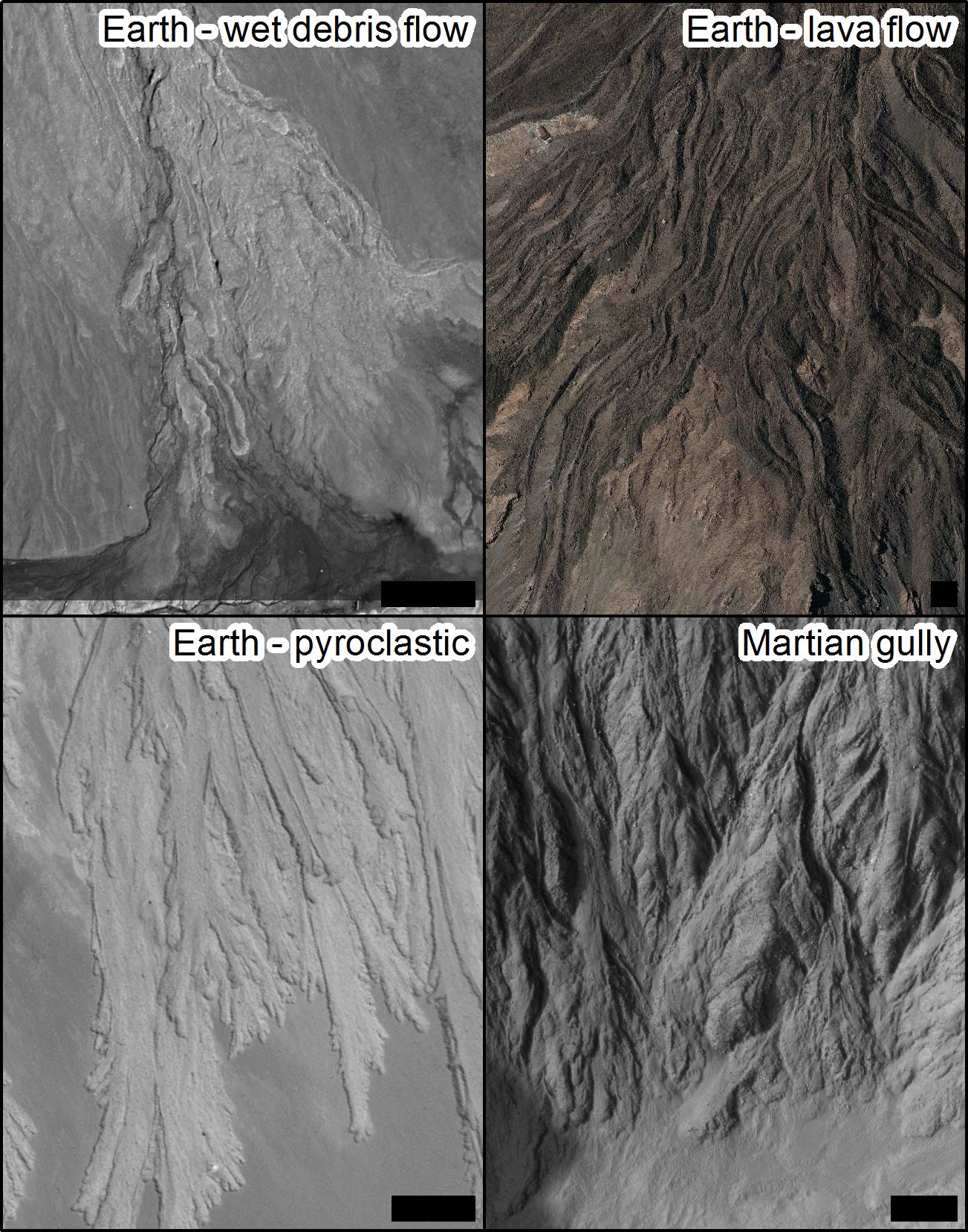
The similarity of water-formed landforms on Earth is often used as a key argument for the involvement of liquid water in shaping the surfaces of other planets. The major drawback of the argument is “equifinality” whereby very similar looking landforms can be produced by entirely different processes. A good illustration is leveed channels with lobate deposits (Image 1). Such landforms can be built on Earth by wet debris flow, lava flow, pyroclastic flows and they are also found on Mars (de Haas et al., 2015; Johnsson et al., 2014) where the formation process is debated.
Image 1: Lobes and levees, scale bars are 50 m in all cases. Wet debris flow deposits in Svalbard, image credit DLR HRSC-AX campaign. Lava flows on Tenerife, aerial image courtesy of IGN, Plan Nacional de Ortofotografía Aérea de España. Self-channelling pyroclastic deposits at Lascar volcano, Chile, Pleiades image. Depositional lobes in Istok crater on Mars, HiRISE image PSP_007127_1345.
Post contributed by Lujendra Ojha, Georgia Institute of Technology.
Recurring slope lineae (RSL) are dark, narrow features forming on present-day Mars that have been suggested to be a result of transient flowing water. RSL extend incrementally downslope on steep, warm slopes, fade when inactive, and reappear annually over multiple Mars years (Images 1 and 2). Average RSL range in width from a few meters (<5 m), down to detection limit for the High Resolution Imaging Science Experiment (HiRISE) camera (~0.30 m/pixel). The temperatures on slopes where RSL are active typically exceed 250 K and commonly are above 273 K. These characteristics suggest a possible role of salts in lowering the freezing point of water, allowing briny solutions to flow.
Image 1: RSL flowing downhill on the steep slopes of Palikir crater in the southern mid-latitude of Mars. Credits: NASA/JPL/University of Arizona.
Post contributed by Dr Peter Grindrod, Department of Earth and Planetary Sciences, University of London
Layered deposits on Mars are a globally-pervasive record of the sedimentary history of the planet. These deposits not only preserve long sequences of Mars’ stratigraphic record, but also exhibit evidence for hydrous minerals and aqueous activity, and thus help to define the habitability through time. Layered deposits are therefore high priority exploration targets for current and future missions, including the Mars Science Laboratory Curiosity Rover, which currently sits at the base of an interior layered deposit (ILD) in Gale Crater.
Image 1. A typical landslide in Valles Marineris, Mars. CTX DTM made at the UK NASA RPIF (Regional Planetary Image Facility) at University College London. Images B21_017688_1685_XN_11S067W and B22_018321_1685_XN_11S068W. Image credit: NASA/JPL/Malin Space Science Systems.
The current climate on Mars does not allow for significant accumulations of surface ice at low latitudes. Therefore ice is only found at the two polar ice caps and in a number of ice-filled craters scattered at northern and southern latitudes (> 70°).
Image 1 : Extent of Late Noachian – Early Hesperian glaciation and location of supraglacial landslides in Valles Marineris (Gourronc et al., 2014).
Posted by Dr P. Senthil Kumar, National Geophysical Research Institute, Council of Scientific & Industrial Research, Hyderabad 500007, India.
Gullies are well-known geomorphic features on Earth where they are mainly formed by erosion due to flow of liquid water. They are also detected on Mars and the Moon and their origin on those bodies are under discussion (Malin and Edgett, 2000; Senthil Kumar et al., 2010). The gullies consist of alcoves (erosional features), channels (features indicating transportation) and fans or debris aprons (depositional structures). These features are clearly observed on the interior walls of impact craters on Mars and widely on the mountain slopes of Earth. Hence, geomorphologists use these features to examine the characteristics of liquid water flow either in the present or past geological records.
Image 1: (a) The Chandrayaan-1 terrain mapping camera image showing the ~7.2-km-diameter fresh crater (centred at 72º12’S, 133º12’E) emplaced in the peak-ring material of Schrödinger basin. The topographic profiles along A-A’ and B-B’ are shown in Figure 1d. A 6860-m-diameter circle fits perfectly to the crater rim from the western to the northern sides of the crater, while the crater rim recedes in other parts due to enhanced crater wall erosion. (b) The shadow-enhanced TMC image reveals the presence of arcuate ridge and the pond material on the crater floor. Note the pond is oriented toward the prominent landslide surface. (c) The TMC image showing the presence of concentric faults along the northwestern crater rim. (d) The topographic profiles along A-A’ and B-B’. The interior wall that contains the landslides (B-B’) is gentler and shallower than the interior wall with the gullies (A-A’). The ridge material is characterized by a higher topographic relief than the surrounding crater floor. The pond material has a flat surface that embays the ridge and other floor materials. See Senthil Kumar et al. (2013) for more details.
Post by Kelsi Singer. Ph.D Candidate, Earth and Planetary Sciences, Washington University, USA.
A typical landslide runs out less than two times its drop height whereas a long-runout landslide can extend 20-30 times the height it dropped from. Long-runout landslides (sturzstroms) are found across the Solar System. They have been observed primarily on Earth (Image 1) and Mars, but also on Venus, and Jupiter’s moons Io and Callisto.
Image 1: An example of a long-runout landslide on Earth is the Blackhawk landslide in the Lucerne Valley, California. This landslide travelled ~8 km. Image Source USGS
Post by Dr. Maarten G. Kleinhans River and delta morphodynamics research group, University of Utrecht, The Netherlands.
Image 1: Subscene of HRSC image presented in Kleinhans et al. (2010) showing an oblique view on a classic bed load-dominated Gilbert delta with a subaqueous lee slope at an angle of about 30°. Delta is about 5 km wide.
Granular materials avalanche when a static angle of repose is exceeded and freeze at a dynamic angle of repose. Such avalanches occur subaerially on steep hillslopes (Image 2), aeolian dunes and subaqueously at the lee side of deltas (Image 1). The angle varies from 25° for smooth spherical particles to 45° for rough angular particles. Noncohesive granular materials are found in many contexts, from kitchen to industry and nature. The angle of repose is an empirical friction parameter that is essential in models of numerous phenomena involving granular material, most of them actually occur at slopes much lower than the angle of repose. The angle of repose is therefore relevant for many geomorphological phenomena. (more…)
In November 2005, the Hayabusa spacecraft performed touchdown rehearsals, imaging navigation tests, and two touchdowns on Itokawa, which is by far the smallest asteroid ever studied at high resolution.
Posted by Bill Hartmann, Planetary Science Institute, Tucson, Arizona, USA.
(Re-posted from IAG Image of the month, March 2007)
This high-resolution MGS MOC image shows overlapping landslide deposits at the foot of the wall in the Ganges region of the Valles Marineris canyon complex on Mars. (more…)