Post contributed by Dr. A. Lucas. Research Scientist, Institut de physique du globe de Paris, France
A detailed analysis of both orbital and seismological data associated to the two largest seismic events recorded during the Nasa InSight mission to Mars (operational from the end of 2018 to the end of 2022), have been done by a team of researchers from the IPGP (Université Paris Cité / CNRS) and their colleagues. They have spotted a clear increase in the number of dust avalanches around the two epicenters of both quakes. The first seismic event was caused by an impactor hitting the Martian surface. The second seismic event was the largest marsquake ever recorded. This finding sheds light on how endogenous and exogenous processes can currently shape the surface of Mars and trigger active mass wasting.
In contrast to Earth, where water is cycled through rivers, oceans and the atmosphere, Saturn’s largest moon Titan is a methane world. Liquid methane falls as rain on Titan’s surface, which forms fluvial landforms (rivers), lakes and seas. It is believed that these methane rivers experience episodic activity, with rainfall primarily occurring at the poles and persisting for 10-100 hours per Titan year, equivalent to 30 Earth years (Lorenz, 2014). Another big difference between the fluvial landforms of Titan and the rivers of Earth is their drainage patterns: the distinctive arrangement and organisation of rivers and streams within a river basin. Most rivers on Earth have a dendritic drainage pattern, resembling a branching tree (Image 1 – Yemeni River), whereas on Titan the majority of fluvial landforms branch at right angles in rectangular drainage patterns [Burr et al., 2013] (Image 1 – Titan River). Titan is also covered by vast regions of linear dune fields (Image 1 – Titan Dunes), similar to those observed in the Namib Desert on Earth (Image 1 – Namib Dunes), primarily within the equatorial latitudes [Rodriguez et al., 2014], thought to be composed of hydrocarbon and nitrile sand-sized particles formed from photochemical reactions in Titan’s atmosphere (Hirai et al., 2023). Although observations of Titan are limited to those taken by Cassini-Huygens from 2005-2017, interactions between rivers and dunes have been observed. It is possible that these interactions could partially explain the presence of rectangular drainage patterns.
Image 1: (Top Left) An example of a typical river valley system on Earth with a dendritic drainage pattern in Yemen [Source: Landsat]. (Top Right) Fluvial landform annotated in blue by Burr et al., (2013) in radar imagery of Titan, showing a rectangular drainage pattern [Source: NASA Cassini]. (Bottom Left) Radar image of linear dunes in the Namib Desert on Earth. The linear dunes, similar in size to those on Titan, are 1-2 km apart. (Bottom Right) Linear dunes in Titan’s sand sea imaged by Synthetic Aperture Radar [Source: NASA Cassini].
Post contributed by Dr. Joe McNeil, Natural History Museum, London
Mars is a planet of geographic contrast. The southern highlands, which comprise the lower two-thirds of the planet form a rugged, heavily cratered landscape that are high in elevation and are some of Mars’ oldest terrains. The upper third of the planet – the northern lowlands – form lightly cratered plains, Mars is a planet of geographic contrast. The southern highlands, which comprise the lower two-thirds of the planet, form a rugged, heavily cratered landscape that are high in elevation and are some of Mars’ oldest terrains. The upper third of the planet – the northern lowlands – form lightly cratered plains, are lower in elevation, and are much younger in age. Where the two hemispheres meet, they form a planetary-scale feature called the dichotomy boundary. One of the most important – and enigmatic – regions of Mars lies in the highlands just south of the boundary at a place called Mawrth Vallis (Image 1). The 650 km-long Mawrth Vallis channel carves its way through Noachian-aged (4.1—3.7 billion years ago) clay-bearing, layered deposits that underpin much of our understanding of the role of liquid water on early Mars (e.g. Bishop et al., 2008; Loizeau et al., 2012). Ongoing work has revealed that these clay-bearing, layered deposits were once much more extensive than they are today. The evidence for this is contained in a population of thousands of mesas, buttes, and hills (‘mounds’) that exist in the lowlands just north of the dichotomy. Image 1A shows the mound population north of the dichotomy within the study area, as well as an example of three individual mounds in Image 1B.
Image 1: Similar strata, different settings. (A) shows a topographic map of the Mawrth Vallis region, with lowlands (teal), highlands (brown), and dichotomy boundary (dashed red line). The mounds are shown as black shapes in the northern lowlands. Inset MOLA (Mars Orbiter Laser Altimeter) globe shows location and global context of the study area. Panels B1 and C1 are CTX (Context Camera) and HiRISE (High Resolution Imaging Science Experiment) images showing a typical mound and a crater in the highlands, respectively, which both exhibit similar dark and light-toned layering at the metre scale (panels B2 and C2; HiRISE IRB).
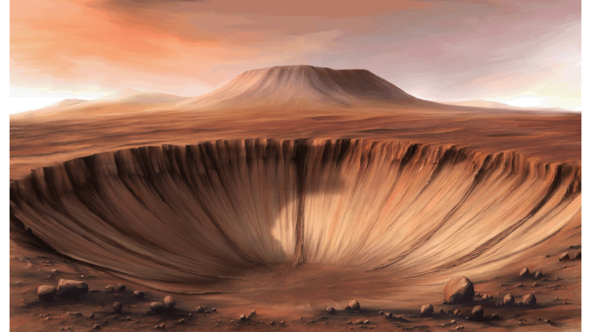
Post contributed by Dr. Eng. Bartosz Pieterek, Adam Mickiewicz University in Poznań and Polish Geological Institute – National Research Institute.
Despite the fact that the Martian surface has been intensively studied for several decades, we still do not fully understand the evolution of the Red Planet. Specifically, our insight into the compositional evolution of Martian magmas is limited, as most volcanic regions were modified or even buried by younger volcanic activity or other geological processes. But luckily not everywhere. By using high-resolution images provided by the Context Camera (CTX) and High Resolution Imaging Science Experiment (HiRISE), on board the Mars Reconnaissance Orbiter, coupled with their stereo-pair digital elevation models, we identified a group of small, kilometer-sized volcanoes in the Claritas Fossae region (examples in Image 1, full area in Image 2). These volcanoes are emplaced on an old and heavily fractured terrain that survived younger volcanic resurfacing event(s). The studied volcanoes, which do not show significant modification by erosion and therefore cannot be very old, show a composition that is different from most other young volcanoes and lava flows found elsewhere on Mars.
Image 1: Examples of studied volcanic edifices with their structural and stratigraphic relationships with the fractured terrain of the Thaumasia and Claritas Fossae regions. (a)The most common type of volcanic edifice occurringin Claritas Fossae. Based on cross-cutting relationships with the older fractured terrain, the volcanic activity has to be younger than the fracturing. This example has been produced using CTX image G17_024955_1524, centered at 27.3983°S and 255.0633°E. (b) This image presents an interesting example of two volcanic edifices separated by a cliff attributed to faulting, which were likely supplied by the same subsurface dike. On Earth, similar-looking edifices may be formed due to the small difference in elevation between vents as evidenced by the Fagradalsfjall eruption (Phase 2; April 2021) in Iceland (Barsotti et al., 2023). This view was produced using CTX image P18_008156_1516, centered at 28.2575°S, and 254.6175°E. All images are available in NASA’s PDS system.
Mercury is a contracting world as evidenced by the abundance of shortening structures observed across the surface of the planet (Image 1). Global contraction as a result of secular cooling of the planetary interior is most likely responsible for widespread compressional tectonism with shortening structures seen cutting all surface materials at all latitudes and longitudes. Shortening structures are accepted as the surface manifestation of thrust faults and folding. Grabens, such as those observed in the images (Image 1-3), are secondary structures found on top of parent shortening structures. The presence of these grabens provide evidence for recent widespread tectonism on Mercury, confirming that global contraction is ongoing.
Image 1: Aspect view of Alpha Crucis Rūpes with horst and grabens present in the foreground of the image. Alpha Crucis Rūpes is located in H09 Eminescu, an equatorial quadrangle. The image is comprised of the H09 south east high incidence west mosaic tile and five individual narrow-angle camera frames (EN0231136925M, EN0231136927M, EN0231136960M, EN0231136962M, EN0231136998M). The image has not been vertically exaggerated and the scale bar is computed for the centre of the image. Image source: NASA/JHUAPL/CIW made by Benjamin Man. Image frames and mosaic tiles are available from NASA’s Planetary Data System Geosciences Node (https://pds-geosciences.wustl.edu/) and the Cartography and Imaging Sciences Node (https://pds-imaging.jpl.nasa.gov/).
Venus is almost the same size as Earth, but it does not presently have plate tectonics. What it has instead, and whether the way it releases internal heat has changed with time, has been the source of debate for decades. A key point of contention has been how the level of current volcanism compares to Earth. Even if all plate-tectonics related volcanism is excluded, Earth still has numerous volcanic eruptions every year at places like the large basaltic shield volcanoes of Hawaii, the Galapagos Islands, and Iceland. The Magellan mission imaged more than 40% of Venus at least twice from 1990 to 1992 with synthetic aperture radar (SAR) at resolutions of 100-200 m, but it is only in the last decade that computer hardware and software have made it possible to systematically search that data for changes with time. Recently the first detection of a surface change of a volcano during the Magellan mission was made, indicating that Venus is presently volcanically active (Herrick and Hensley, 2023).
Image 1: A) and B) show the same area on Venus as imaged by the Magellan spacecraft eight months apart in 1991; North is up. For comparing SAR images to overhead photographs, image A) can be thought of as looking at the scene from a vantage point off to the right with the sun shining from the left; in B) the vantage point is from the left and the sun is to the right. The shape of the feature labeled “Expanded Vent” has changed over the interval between images, meaning that the volcano on which the vent is perched must have erupted.
Post by Giulia Magnarini, PhD candidate, Department of Earth Sciences, University College London, UK.
The availability of high resolution imagery of the surface of Mars from NASA’s Mars Reconnaissance Orbiter CTX and HiRISE cameras (NASA PDS) allow us to reconstruct fantastic 3D views of the martian topography using stereophotogrammetry technique. Digital terrain models (DTMs) are obtained using the difference in two images of the same target taken from different angles. In the process, orthoimages are generated and draped over the DTM. CTX stereo-derived DTMs have 20 m/px resolution; HiRISE stereo-derived DTMs have 1-2 m/px resolution. This technique is applied to the study of martian long runout landslides and it represents a powerful tool, as the 3D reconstruction allows detailed observations and morphometric analysis of these landforms and their morphological features (Images 1-3).
Image 1: Long runout landslide in Ganges Chasma, Valles Marineris, Mars. CTX stereo-derived DTM at the Mineral and Planetary Sciences division of the Natural History Museum in London. Vertical exaggeration 2x. Image pair: P20_008681_1722_XN_07S044W and P20_009037_1718_XN_08S044W.
Post by Dr. Colin Dundas, U.S. Geological Survey, Astrogeology Science Center
Martian “gullies” are a class of landforms on steep slopes, characterized by an upper alcove and a depositional apron, linked by a channel. On Earth, similar features would likely be termed ravines or alluvial fans. The Martian features usually appear geomorphically fresh, with sharply defined channels and no superposed impact craters. Changes were first detected in Martian gullies over a decade ago, and such observations have become more common as high-resolution repeat image coverage has expanded. This current activity correlates with seasonal frost (which is mostly CO2 on Mars) and has resulted in substantial modification of some gullies, leading to a debate over whether CO2 alone is sufficient to form them without liquid water.
Image 1: Subsection of HiRISE image ESP_023809_1415 (https://www.uahirise.org/ESP_023809_1415) at reduced resolution, providing context and an overview of the gully system. North is up and light is from the upper left.
Post contributed by Oliver White, Search for Extraterrestial Intelligence Institute.
Io is the innermost Galilean satellite of Jupiter, and with over 400 active volcanoes, it is the most volcanically active body in the Solar System, a consequence of tidal heating from friction generated within its interior as it is pulled between Jupiter and other Galilean satellites. Constant volcanic resurfacing means that the oldest surface is likely not more than a million years old (Williams et al., 2011). No instrumentation specifically designed to measure topography has ever been deployed to Io, but White et al. (2014) constructed a global digital elevation model (DEM) covering ~75% of Io’s surface from all available stereo coverage in Voyager and Galileo imaging, and controlled it using Galileo limb profiles (Image 1). This map represents a continuous topographic dataset that has revealed topographic variations not otherwise apparent in Voyager and Galileo imaging and limb profiles, and which may be correlated with geologic units (e.g. Williams et al., 2011). While not providing coverage across the entire globe, the map stands as the most comprehensive continuous topographic data set of Io’s surface, at least until a spacecraft arrives at Io with a dedicated photogrammetric camera or a laser altimeter on board.
Image 1: Global stereo DEM overlain on a mosaic of Voyager and Galileo images in simple cylindrical projection at 2 km/pixel. Gaps in the DEM represent masked noise or absence of stereo coverage. A broad smoothing filter has been applied to the plains areas of the DEM post-mosaicking but not to comparatively high relief features such as mountains, layered plains, and some paterae (volcanic craters). The width of the map at the equator is 11,445 km.
Post by Dr. T. de Haas, Department of Geography, Durham University.
Martian gullies are composite landforms that comprise an alcove, channel and depositional fan. They are very young geological features, some of which have been active over the last million years. Water-free sediment flows, likely triggered by CO2 sublimation, debris flows, and fluvial flows have all been hypothesized to have formed gullies. These processes require very different amounts of liquid water, and therefore their relative contribution to gully-formation is of key importance for climatic inferences. Formative inferences based on surface morphology may be biased however, because of substantial post-depositional modification (Images 1-3).
Image 1: Morphometry, morphology and stratigraphy of depositional landforms in Galap crater. (a) Overview and digital elevation model of Galap crater. (b) Detail of northwestern slope showing gradients of catchment and depositional fan. (c) Detail of proximal fan surface. (d) Detail of distal fan surface. (e) Detail of fan surface with incised channels; the dashed line indicates the rockfall limit. (f) Example of stratigraphic section. (h) Same stratigraphic section as in f, but with optimized contrast in the section. Arrows denote downslope direction. HiRISE image PSP_003939_1420.
The nature of the early Martian climate is one of the major unanswered questions of planetary science. To date the geologic evidence that Mars once had large amounts of surface liquid water is conclusive, but geomorphic constraints on the duration for which that water flowed are much weaker. In addition, much of the geochemical evidence points towards surface conditions that were not warm and wet for long time periods. The evidence points towards a hydrological cycle that was intermittent and not permanently active 3.8 billion years ago. However, in a recently published article myself and colleagues report that flowing water and aqueous environments formed thick, widespread sedimentary plains 3.8 billion years ago in the northern rim of the Hellas basin on Mars.
Image 1: 3D view of the northern Hellas plains, including hills, plains, erosional windows, and impact craters with their interpreted lithology. Mosaic of CTX images draped on MOLA topography.
Post contributed by P. Senthil Kumar, CSIR-National Geophysical Research Institute, Hyderabad, India
Geomorphology of terrestrial planets provides important insights into how various exogenous (e.g., meteorite impact, wind activity, glaciation) and interior geological processes (e.g., tectonics, volcanism) interact with the planetary surface. The tectonic features (faults, folds and fractures) shed light on the past and on-going seismo-tectonic processes operating on a planetary body. On Earth, seismometer networks are used in the direct instrumental observations of earthquake locations and their sizes for many decades. For other planets, seismic observations are rare. On the Moon, Apollo seismometers recorded moonquakes only during a brief period of 1969-1976. Annually, about 2000 deep moonquakes originating at 800-900 km depth, tens of shallow moonquakes at 0-100 km depth and around 200 meteoroid impacts were observed (Nakamura et al., 1979; Nakamura, 1980). While the deep moonquakes are produced by tidal forces, the sources of shallow moonquakes are thought to be of tectonic in origin. However, crustal tectonic structures responsible for shallow moonquakes are poorly understood.
Figure 1: (upper panel) LROC NAC images showing the en echelon pattern of a lobate scarp, located near the southern basin wall of Schrodinger basin. Hundreds of boulder falls and their trails are found on the basin wall about 5-7 km south of the lobate scarp. The boulders are shown as points (open circles filled with yellow) and are not to the scale. Note the largest number of boulder falls is seen between 129° and 130° longitudes. (lower panel) LROC NAC (M139078014RE) image showing the boulder trails of variable lengths and widths containing some prominent boulders at the terminal ends of the trails. A 23 m diameter boulder (labelled), the largest in this scene, produces a trail (also labelled) slightly wider than the boulder indicating a possible size reduction during its transport from the source region to its current location. Most boulder trails criss-cross each other.
Post contributed by Dr. Petr Brož, Institute of Geophysics of the Czech Academy of Science
Volcanism is an important process which shapes the surfaces of all terrestrial planets, and is still active on Earth, Jupiter’s moon Io, and perhaps on Venus. On Earth, volcanoes with wide variety of shapes and sizes exist; however, the size of volcanoes is anti-correlated with their frequency, i.e. small volcanoes are much more numerous than large ones. The most common terrestrial volcanoes are represented by kilometre-sized scoria cones (Figure 1a). These are conical edifices of pyroclastic material originating from explosive volcanic activity. Degassing of ascending magma causes magma fragmentation on eruption piling up the pyroclasts around the vent as a cone. Interestingly, scoria cones as known from Earth, have not been observed commonly on any other terrestrial body in the solar system despite the fact that magma degassing, and hence magma fragmentation, has to occur on these bodies as well.
Figure 1: Example of a terrestrial scoria cone (panel a, Lassen Volcanic National Park, California, photographed by the National Park Service) and its putative martian analogue (panel b, detail of CTX image P22_009554_1858_XN_05N122W).
Post contributed by Henrik Hargitai, NASA Ames and ELTE, Hungary
Everyone has a story. The narrative of who we are is created by us, our actions and interactions, sometimes just drifting with the events we live through. Landscapes like the one shown in Image 1, tell a geologic story. We translate it to human language and categories. Landscapes are the interface between a planetary body, its atmosphere and the cosmic environment. They change, age, and renew. A flood from a distant source, an impact, settling dust, all imprint onto it. Its history is recorded in its materials and its relief. With age, it depicts an ever more complicated story until resurfacing destroys its history. It’s increasingly popular to explain geology by processes. In real life, however, processes are not always clear cut and as we enter the age of multidisciplinary studies, many of us accept people who are different, we also recognize that landforms are shaped by a multitude of processes, they are not black or white, but all shades of… any color. Is a channel volcanic or fluvial? Well, maybe it’s both, and tectonic, too, with a pinch of ice-rich material that is of course sublimating. Even the types of question we can think of evolve, and this is happening in science, humanities and politics in parallel. Lowell’s Mars? Flat plains and marshes. Perhaps he didn’t even have enough creativity? Nature ‘s creativity always surpasses our own.
Image 1: The terminus of an inferred lava flow in one of the Marte Vallis outflow channels at 17.94 N, 185.51 E (Keszthelyi et al. 2008) (CTX image P03_002027_1979, credit NASA/JPL/MSSS)
Post contributed by Solmaz Adeli, Deutsches Zentrum für Luft- und Raumfahrt (DLR), Institute of Planetary Research, Berlin, Germany
Image 1: Kārūn Valles located on the rim of the Ariadnes Colles basin. The visible channel head and deep grooves are shown (detail of CTX image D10_031182_1435). (b) The Kārūn Valles alluvial fan. Note the elongated depositional bars and their wide distribution. (c) A zoom on one of the braided bars. The flow direction is indicated by dashed arrows (detail of HiRISE image ESP_043261_1440).
The Amazonian period on Mars, meaning roughly the last 3 Ga, is globally believed to have been cold and hyperarid [e.g., Marchant and Head, 2007]. Recent geomorphological observations, however, have revealed the presence of well-preserved Amazonian-aged fluvial valleys in both the north and south mid-latitude regions of Mars [Howard and Moore, 2011; Hobley et al., 2014; Salese et al., 2016; Wilson et al., 2016]. These features point to one or several climate change phase(s) during Amazonian which could have sustained liquid water at the martian surface. These climate changes could have been triggered by obliquity oscillations [Laskar et al., 2004] causing the transportation of ice from polar regions and its re-deposition at lower latitudes. Episodic melting events during Amazonian, subsequently, formed valleys and other fluvial features, in the mid-latitude regions.
Post contributed by Dr. Ryan C. Ewing, Department of Geology and Geophysics, Texas A&M University
Ripples cover the surfaces of sand dunes on Earth and Mars. On Earth, ripples formed in typical aeolian sand (e.g., 0.1 and 0.3 mm) range in wavelength between 10 and 15 cm and display a highly straight, two-dimensional crestline geometry. Ripples are thought to develop through a process dominated by the ballistic impacts of saltating sand grains in which wavelength selection occurs through the interplay of grain size, wind speed, the saltation trajectories of the sand grains, and ripple topography.
Figure 1: Wind-blown impact ripples from Mesquite Flat Sand Dunes, Death Valley, USA. Pen is ~15 cm. Inferred transport direction is to the right on the image. Image credit: Ryan C. Ewing
Post contributed by Colman Gallagher, University College Dublin.
Eskers are sinuous ridges composed of deposits (Image 1) laid down from meltwater flowing in tunnel-like conduits beneath glaciers (Image 2). On Earth, eskers are common components of deglaciated landscapes (Image 3) but eskers also can be observed emerging from the margins of intact glaciers.
Image 1. A longitudinal section through part of an esker ridge in Ireland. Esker sediments are layered and often extremely coarse. The structures of the layers represent highly variable depositional settings within subglacial meltwater tunnels. The coarse sedimentary calibre represents extremely powerful meltwater flows.
Post contributed by Abdallah S. Zaki, Department of Geography, Ain Shams University.
The evolution of inverted topography on Earth and Mars can result from surface armouring of the channel, infilling of channels/valleys by lava flows, and cementation of valley floor by secondary minerals (such as, calcium carbonate, gypcrete, ferricrete, calcrete) – see post by Rebecca Williams. This post specifically concerns inverted wadis, which have been identified in a number of localities on Earth, including multiple localities in the Sahara and Arabia, Australia, the Ebro Basin of Spain, Utah, and New Mexico and west Texas (e.g., Miller, 1937; Maizels, 1987; 1990). Inversion of relief is observed commonly on Mars, for example, Eberswalde Crater, Arabia Terra, Juventae Chasma, Olympus Mons, and Antoniadi Crater (e.g., Pain et al., 2007; Williams et al., 2007).
Image 1: Google Earth image of the dendritic pattern preserved in inverted wadis in eastern Saudi Arabia.
Image 1 shows a distinctive flow deposit southwest of the Cerberus Fossae on Mars. The flow source is a ~20 m deep, ~12 x 1.5 km wide depression within a yardang field associated with the Medusae Fossae Formation. The flow traveled for ~40 km following topographic lows to leave a deposit on average 3-4 km wide and up to 10 m thick. The surface morphology of the deposit suggests that it was produced by the emplacement of a fluid flowing in a laminar fashion and possessing a finite yield strength. There is an ongoing debate about whether flows in this region of Mars are lava flows or water-rich debris flows.
Image 1: Location of the distinctive flow deposit, called Zephyria Fluctus, just north of the equator on Mars. The inset at top left shows the broader context of the flow. The grey area is the flow’s extent and black boxes indicating the position of Images 2 and 3 (Fig. 2) and Image 4 (Fig. 4). The inferred flow direction is from SW to NE. Mosaic of CTX images D01_027675_1806, D04_028941_1805 and G19_025697_1803.
Post contributed by Dr. M. Ramy El-Maarry, Institute of Physics, University of Berne, Switzerland.
The European Rosetta spacecraft went into orbit around comet 67P/Churyumov-Gerasimenko in Aug, 2014. Since then, the spacecraft’s imaging instruments, particularly the OSIRIS camera, have been sending images of the comet’s surface in unprecedented detail showing an amazingly complex landscape and a suite of geomorphological features that suggest many processes are currently at work and acting on the surface.
Image 1: OSIRIS images of various polygonal fracture systems on the surface of the comet.


