Antipodal Terrains on Pluto

Post contributed by C. Adeene Denton, Department of Earth, Atmospheric, and Planetary Sciences, Purdue University, USA.

Antipodal terrains are unusual regions of hilly, lineated, or otherwise disrupted terrain that are on the direct opposite side of planetary bodies to large impact basins. These mysterious terrains have been observed at the antipodes to the Caloris basin on Mercury and the Imbrium basin on the Moon, where their formation is considered to be indicative both of the impact’s size and the specificities of the planetary body’s interior structure. Recent revisiting of data from the New Horizons spacecraft revealed an unusual region of disrupted and lineated terrain on Pluto’s far side that is roughly antipodal to the massive Sputnik Planitia basin, the feature sometimes referred to as “Pluto’s Heart” (Image 1). If the lineated terrain is indeed connected to the large impact believed to have formed Sputnik Planitia, then the two geologic features offer a new and unusual way to probe Pluto’s interior: seismology through giant impact.

Image 1: Comparison of Pluto’s nearside (left) and farside (right) with Sputnik Planitia and its proposed antipodal terrain indicated. The location of Image 3 is also indicated. Images modified from full-scale planetary images taken by the New Horizons spacecraft, via NASA/JHUAPL/SWRI.

(more…)
The Mysterious Morphology of Hekla Cavus, Pluto

Post contributed by Dr. Caitlin Ahrens, NASA Goddard Space Flight Center, USA.

Cryovolcanism involves the transfer of icy or gaseous subsurface materials either to the surface (eruptive) or through the subsurface (non-eruptive) of an icy planetary body. It differs from magmatism and volcanism on Earth, which involves the migration and eruption of molten rock. Cryovolcanism is thought to have operated on several icy bodies in the Solar System, including Enceladus, Triton, Pluto, and possibly Europa. Cryovolcanism results primarily from internal heat-producing processes, and excludes sublimation and condensation processes at the surface. In the case of Pluto, there is evidence for a subsurface fluid layer, the presence of cryovolcanoes, and cryovolcanic subsurface materials (called cryomagma) which can contain ammonia and methane. Due to the presence of a deformable subsurface layer, it is possible for the material to shift, causing uplift followed by a collapse-type event. This is a possible scenario at Hekla Cavus (Image 1), a large, elongated, and irregular depression situated within a much larger north-south (N-S) ridge-trough system outlined by mountain ranges.

Image 1: Image of Hekla Cavus taken from the LORRI instrument onboard the New Horizons.

(more…)

Polygonal Impact Craters on Miranda, Charon, and Dione

Post contributed by Dr. Chloe B. Beddingfield, The SETI Institute and NASA Ames Research Center

Some impact craters are classified as polygonal impact craters (PICs), which have at least one straight rim segment, as shown in Image 1. The morphologies of PICs are shaped by pre-existing, sub-vertical structures in the target material, such as normal and strike-slip faults, joint sets, and lithologic boundaries. Because the straight rim segments of PICs only form where pre-existing structures are present, PIC morphologies can be used to analyze fractures that are buried by regolith or too small to be seen in available spacecraft images. On the icy Uranian moon Miranda, PICs are widespread across its southern hemisphere, which was imaged by the Imaging Science System (ISS) onboard the Voyager 2 spacecraft. Some of these PICs reveal previously undetected fractures that suggest Miranda has experienced multiple periods of tectonic activity.

Image 1: Examples of two PICs identified on the Uranian moon Miranda. Black arrows indicate the straight rims of these PICs. The Voyager 2 ISS image mosaic shown here includes the following images, from top to bottom: c2684620 (light blue box), c2684629, c2684617 (dark blue box).

(more…)

Chaotic Terrain on Pluto, Europa, and Mars

Post contributed by Helle L. Skjetne, PhD candidate, Department of Earth and Planetary Sciences, University of Tennessee, Knoxville, USA.

Chaos terrain is formed by disruption of preexisting surfaces into irregularly shaped blocks with a “chaotic” appearance (Image 1). This typically occurs through fracturing (that can be induced by a variety of mechanisms), and the subsequent evolution of these blocks can follow several paths (Image 2). These distinctive areas of broken terrains are most notably found on Jupiter’s moon Europa, Mars, and Pluto. Although chaos terrains on these bodies share some common characteristics, there are also distinct morphological differences between them (Image 1). The geologic evolution required to shape this enigmatic terrain type has not yet been fully constrained, although several chaos formation models have been proposed. We studied chaotic terrain blocks on Pluto, Europa and Mars to infer information about crustal lithology and surface layer thickness (Skjetne et al. 2020).

Image 1: Examples of chaotic terrain “blocks” (referring to each mountain-like topographic feature). Chaos on Pluto in a) Tenzing Montes and b) Al-Idrisi Montes, respectively (New Horizons image at ~315 m px–1), c) Hydraotes Chaos on Mars (Mars Odyssey THEMIS daytime infrared global mosaic at 100 m px–1), and d) Conamara Chaos on Europa (Galileo 210–220 m px–1 East and West RegMaps).

(more…)

Pluto, Up Close!

Post contributed by Dr Veronica Bray, Lunar and Planetary Laboratory, University of Arizona.

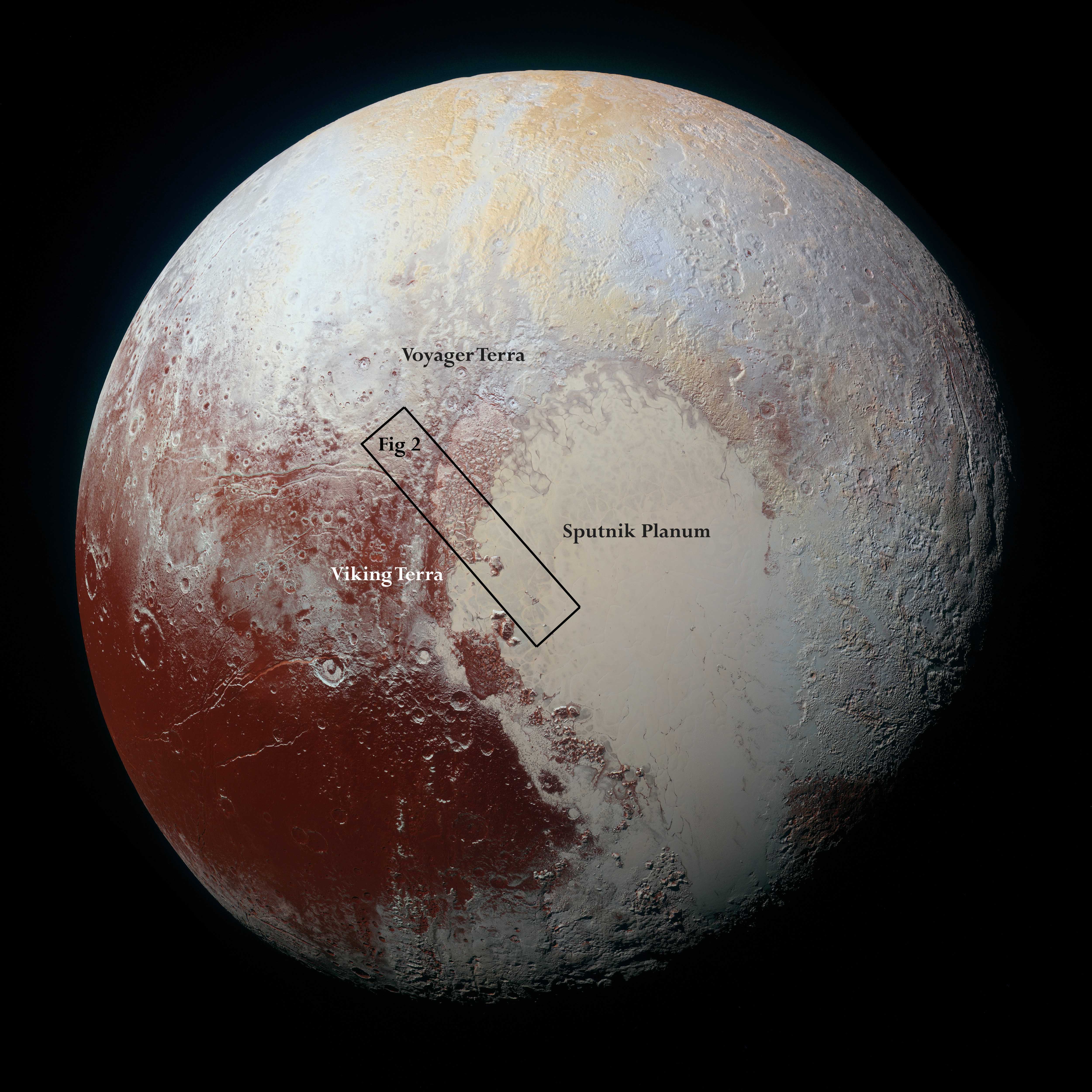
Images of Pluto coming back from NASA’s New Horizons spacecraft have revealed many unexpected landforms and show extreme albedo and compositional variations across the dwarf planet’s surface. This blog post concentrates on one high-resolution swath across the boundary between the cratered terrains of Viking and Voyager Terra and the smoother ices of Sputnik Planum (see Figure 1). Take time to scroll down this long image (Figure 2), that covers ~530 km of Pluto’s surface at around 30°N.

pluto

Figure 1: A global image of Pluto created from high-resolution (2.2km/pixel) panchromatic images from the LORRI instrument and lower-resolution (5km/pixel) colour data from the Ralph/Multispectral Visual Imaging Camera. The colours have been enhanced to show the diversity of the surface units by combining blue, red and near infra red images. Credits: NASA/JHUAPL/SWRI.

(more…)

  • Enter your email address to follow this blog and receive notifications of new posts by email.

  • Io

  • Blog Stats

    • 192,899 hits