Post contributed by Dr Lisanne Braat, European Space Agency (ESA)
Deltas form when a river flows into a standing body of water. When the flow decelerates the sediment carried by the river settles and forms the delta. On Earth we have numerous active deltas where rivers meet lakes, seas, and oceans. Examples of Earth’s deltas can be seen on the left side of Image 1. On Mars, we observe many remnants of ancient deltas that are no longer active (shown on the right side of Image 1), such as the delta in Jezero Crater where the Perseverance rover currently explores. Preserved sediment deposits in these Martian deltas provide valuable insights into past processes on the planet’s surface and the presence of water. To better understand these landforms on Mars, we rely on knowledge gained from active delta systems on Earth. However, is it fair to do so when the gravity on Mars is much lower? How does gravity affect sediment transport and delta morphology?
Image 1: Animated GIF comparing Deltas on Earth and Mars. Left, examples of active deltas on Earth (source: Landsat). Right, examples of preserved ancient deltas on Mars (source: JMARS composite of CTX Global Mosaic, Murray Lab, and HRSC MOLA Blended DEM 200m v2).
Post contributed by Dr. Zach Dickeson, Department of Earth Sciences, Natural History Museum, London, UK.
At geological timescales, individual lakes are only transient features on the Earth’s surface. Conditions within lake basins change over time, eventually filling with sediment, drying up, or draining completely by steady erosion (or catastrophic breach) of the basin margin. Sites where lakes existed in the past are known as palaeolakes, and in addition to Earth, hundreds of examples have been identified on Mars (Goudge et al., 2015). Rather than a single characteristic landform, palaeolakes on Mars are typically identified by a set of topographic and morphological features such as shown in Image 1. Careful investigation of associated river valleys, deltas, layered deposits, and shoreline terraces can reveal details of a lake’s origin, development, and eventual demise (Dickeson et al., 2022).
Image 1: Deposits and landforms within a palaeolake in Arabia Terra, Mars. Two past lake levels are represented by contours defined by outlet valley elevations. The inlet valley is visible at the bottom of the image where it enters the palaeolake basin. A broad, flat-surfaced sediment fan with a steep front sits at a higher elevation, and is incised through by the inlet valley, which continues into the basin to terminate at the apex of a lower and more heavily weathered sediment fan. The two fans are interpreted as deltas, and match the two different fill levels within the palaeolake. Context Camera image D12_031993_2114_XN_31N014W; http://viewer.mars.asu.edu/viewer/ctx/D12_031993_2114_XN_31N014W; NASA/JPL/MSSS/University of Arizona.
Post contributed by Dr Alex Morgan, Planetary Science Institute, USA
Alluvial fans are sedimentary deposits that form at the base of mountain fronts as a channel exits a steep, confined valley onto more gently sloped and unconfined terrain (Image 1). The channel loses its ability to transport sediment due to the reduction in slope and the lateral expansion of flow, and over time sediment is deposited into a semi-conical shape. The effects of water on a landscape are the most unambiguous markers of past climatic environment, and the distribution of alluvial fans provides a record of where and when liquid water was capable of transporting sediment on Mars in the past. Furthermore, as depositional features in close proximity with their sediment sources, alluvial fans preserve a record of environmental changes that occurred while sediment was being transported and deposited. In this study, we leveraged high resolution images from the CTX camera on Mars Reconnaissance Orbiter, which cover the entire surface of Mars, to conduct a global survey for fan-shaped sedimentary landforms across the martian surface and explore their implications for environmental change.
Image 1: A large alluvial fan in Harris crater, centered on 21.5°S, 67°E. The down-fan-trending ridges are interpreted to be paleochannels now in inverted relief due to preferential erosion of finer overbank deposits. This particular fan exhibits evidence for multiple episodes of sedimentation (Williams et al., 2011). CTX image G02_019160_1580_XN_22S292W.
Post contributed by Emily Bamber (PhD Candidate), Jackson School of Geoscience, University of Texas at Austin
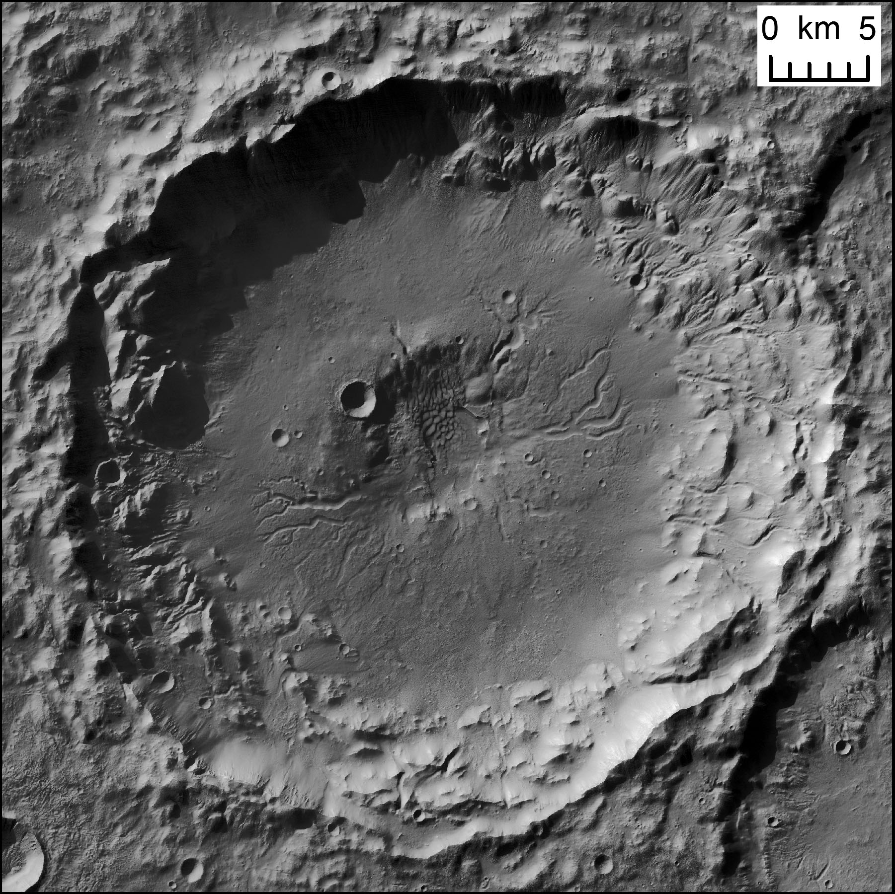
Impact craters are a common feature of the surface of Mars and other planetary bodies. Impact craters are formed by the force of an asteroid or comet colliding with the surface of a planet. This collision excavates a bowl-shaped depression and causes uplift, deformation and deposition of excavated material to form a crater rim, which can rise hundreds of meters above the surroundings (for a crater on the scale of tens of kilometers in diameter). However, some of Mars’ impact craters stand out from their counterparts on other rocky planets and moons because they have been affected by the action of erosion by liquid water. In comparison to the Moon, Mars’ craters deviate much more from their original geometries, but perhaps more strikingly, more than 400 craters on Mars’ surface have an inlet valley (Image 1); a valley which starts from outside the crater and crosses the rim crest (e.g. Cabrol & Grin, 1999; Goudge et al., 2016). Although no substantial liquid water currently flows on Mars today, the preserved valleys likely delivered water from a crater’s surroundings to the crater interior, at some time in the distant past. Therefore, their formation could give clues to Mars’ watery past.
Image 1: An impact crater on Mars, at 16.2°N, 53.2°W with a high-standing crater rim around its circumference. To the south of the crater, there is an inlet valley that crosses the rim divide, with two wide tributaries. The valleys are now dry, but liquid water in Mars’ past likely incised them. The crater does not have an outlet valley (where water may have exited the crater in a through-flowing system). Background is a CTX DEM (from the stereo pair B21_017806_1955 – B21_017951_1955), HRSC DEM h2277_0000 and global MOLA DEM, overlain on CTX image B21_017806_1955 and THEMIS global IR mosaic.
Post contributed by Dr Joel Davis, Department of Earth Sciences, Natural History Museum, UK
On Earth, the interplay between tectonics and sedimentation is commonplace. In regions such as Death Valley, USA, extensional tectonic processes have formed sedimentary basins, where the subsequent erosion of the landscape causes the formation of features such as alluvial fans. Alluvial fans are conical-shaped, sedimentary deposits usually formed by stream flows in upland regions. Later tectonic activity can lead to the deformation and relative uplift of these landforms. A new generation of alluvial fans may then form, overprinting the older generation and extending down to the new position of the basin floor.
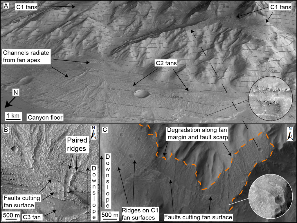
To contrast, as most alluvial fans on Mars are found within impact craters, they do not show evidence of tectonic deformation. The alluvial fans hosted within the canyons of Valles Marineris appear to be an exception to this (Figure 1). Valles Marineris may have developed over billions of years by repeated episodes of normal faulting. In several regions of Valles Marineris, not only are alluvial fans found on the current floor, but remnants of such features are found on the canyon walls as well – perched several kilometres above the floor!
Figure 1: Faulted alluvial fan deposits in Coprates Chasma, Mars. (A) Oblique Context Camera (CTX) image of multiple generations of alluvial fan deposits, offset by faulting. Credit: NASA/JPL/MSSS. Inset shows High Resolution Imaging Science Experiment (HiRISE) image of bright-toned layering in fan margins. Topographic contour interval is 200 m. Credit: NASA/JPL/UoA. (B) HiRISE mosaic of C2 alluvial fan deposits on canyon floor, where surfaces contain distributary channels and paired ridges, cut by multiple faults. Youngest C3 fans superpose faults and are local to C2 fan apices. Credit: NASA/JPL/UoA. (C) Planform CTX mosaic of oldest (C1) alluvial fan deposits (perched terraces), which have been faulted and later eroded (orange line). NASA/JPL/MSSS. After Davis et al., 2021.
Post contributed by Divya M. Persaud, University College London, UK/NASA Jet Propulsion Laboratory, USA.
This canyon, Sakarya Vallis, cross-cuts the central mound of Gale Crater, Mars, and was probably formed by fluvial erosion. Gale Crater, the exploration site of the Curiosity rover, has undergone a complex geologic history of aqueous and aeolian processes. The central mound is a topographic high in the center of the crater, on which the ~5.2 km peak Aeolis Mons is situated. This feature sports several canyons (which cut through it), yardangs, and spectacular exposed layers, and its origins are uncertain (likely aeolian and/or fluvio-lacustrine). Image 1 shows the largest canyon on the mound, at 26 km long, up to 3.5 km wide, and up to 400 m deep. The hundreds of meters of exposed layers in this canyon provide a glimpse into the depositional history of the central mound of Gale crater.
Image 1: A 3D perspective view of the interior of the channel, visualized from HiRISE Digital Terrain Model DTEEC_006855_1750_007501_1750_A01 and HiRISE image PSP_007501_1750. This view shows the exposed layers and a possible fracture on the eastern wall (left), while the topography of the bright, inverted feature can be seen on the floor of the canyon. The floor of the canyon is overlaid by ripples. The scalebar is oriented north.
The center of Sakarya Vallis is approximately 27 km from and 700 m higher in elevation than the base of Gediz Vallis, the approximate location of the Curiosity rover (as of February 2021, sol 3038). The layers exposed in Sakarya Vallis therefore represent later depositional events than those encountered by Curiosity to date. As the rover ascends the mound towards Aeolis Mons, this geology could help contextualize rover observations and constrain lateral differences in palaeoenvironment.
The canyon cross-cuts layered hydrated sulfates in the lower mound, while spectra of the upper mound point to a dust composition. The surface of the upper unit (Image 2) is an etched, yardang unit. Yardangs are streamlined features eroded by the wind.
Image 2: A) An overview of the canyon on the central mound from CTX imagery. The slope of the canyon is to the northwest. The surface of the mound is etched by yardangs and in-filled craters. B) A close-up view of the northern, lower half of the canyon, from HiRISE image PSP_007501_1750. The extent of the inverted feature can be seen on the floor.
Within the canyon are possible point bars formed by past rivers (Image 2), mass-wasting features (Image 3), ripples (Image 1), and boulder-scale lag deposits along the floor and clifftops. A bright, topographic feature resembling an inverted channel or meander belt (Image 1) extends along much of the canyon floor and may represent later flow of liquid water, and subsequent topographic inversion by erosion of materials surrounding the channel.
Image 3: Layers exposed in the northern part of the canyon in a possible mass-wasting feature (HiRISE image PSP_007501_1750). These layers are sub-horizontal and dip gently to the northwest. The ripples on the floor have wavelengths of 10-20 m.
Post contributed by Axel Noblet, Laboratoire de Planétologie et Géodynamique de Nantes, CNRS/Université de Nantes, France
Jezero Crater on Mars will soon be explored by NASA’s Perseverance rover. This crater has been interpreted as a paleolake. It contains two fan-shaped deposits in the northern and western portions of the crater. These deposits have been interpreted as ancient deltas. The delta located in the western portion of Jezero (Image 1) displays some of Mars’ best-preserved fluvio-deltaic features, and exhibits a variety of structures such as inverted channels and point-bar strata (Image 2). This delta contains a precious record of various depositional environments, and in situ exploration can give us insight of Mars’ fluvio-lacustrine history. The association of well-preserved lacustrine features with orbital detections of carbonates along the inner margin of Jezero points toward high biosignature preservation potential for these deposits. Hence Jezero’s western delta contains a record of the evolution of Mars’ ancient climate and possible habitability. The presence of a long-lived lake system on Mars is astrobiologically significant, and the deposits within the Perseverance landing site could have preserved biosignatures that could be investigated and cached for a future sample return mission.
Image 1: 3D view of Jezero western delta, looking north from the center of the crater. The data visualized here is a CTX camera orthorectified mosaic draped over a CTX digital terrain model (horizontal resolution: 20m/px). The triangular ‘birdfoot’ shape of the delta is clearly visible, and inverted channels can be seen radiating from the apex of the delta. The inlet valley goes diagonally from the upper left of the image through the delta deposits. The crater floor appears as the smooth terrains on the lower part of the image.
Post contributed by Solmaz Adeli, Deutsches Zentrum für Luft- und Raumfahrt (DLR), Institute of Planetary Research, Berlin, Germany
Image 1: Kārūn Valles located on the rim of the Ariadnes Colles basin. The visible channel head and deep grooves are shown (detail of CTX image D10_031182_1435). (b) The Kārūn Valles alluvial fan. Note the elongated depositional bars and their wide distribution. (c) A zoom on one of the braided bars. The flow direction is indicated by dashed arrows (detail of HiRISE image ESP_043261_1440).
The Amazonian period on Mars, meaning roughly the last 3 Ga, is globally believed to have been cold and hyperarid [e.g., Marchant and Head, 2007]. Recent geomorphological observations, however, have revealed the presence of well-preserved Amazonian-aged fluvial valleys in both the north and south mid-latitude regions of Mars [Howard and Moore, 2011; Hobley et al., 2014; Salese et al., 2016; Wilson et al., 2016]. These features point to one or several climate change phase(s) during Amazonian which could have sustained liquid water at the martian surface. These climate changes could have been triggered by obliquity oscillations [Laskar et al., 2004] causing the transportation of ice from polar regions and its re-deposition at lower latitudes. Episodic melting events during Amazonian, subsequently, formed valleys and other fluvial features, in the mid-latitude regions.
Post contributed by Francesco Salese from IRSPS/Dipartimento INGEO, Università D’Annunzio, Pescara, Italy.
Mars, is one of the planetary bodies where water flowed and where it may transiently flow today under certain conditions. Many martian paleodrainage systems and well-preserved fluvial and lacustrine deposits have been recognized and studied in the last two decades (see further reading). Widespread dendritic valley networks and the presence of extensive fluvial features on ancient martian terrains suggest that a relatively “warm and wet” climate was prevalent early in the planet’s history (about 3.7 Ga). This is in stark contrast with the hyper-arid, extremely cold climate that is thought to have persisted from 3 Ga until the present (Amazonian Era). The subject of this post is Moa Valles [Salese et al., 2016], which is a 2 billion year old paleodrainage system (Figure 1) that is nearly 300 km long and is carved into ancient highland terrains of Tempe Terra in the northern hemisphere of Mars. Understanding the origin and evolution of this type of complex and interconnected paleo-fluvio-lacustrine system is critical for understanding the early martian climate.
Figure 1: The upper panel shows the THEMIS-VIS daytime mosaic of Moa Vallis system.The lower panel is a line drawing showing the channel system in blue lines, red dotted lines represent wrinkle ridges, the drainage basin is delimited in grey, and fan-shaped and deltaic deposits in orange. The total mapped length of the channel as shown here is ~325 km, and the flow direction is towards the east.
Post contributed by Abdallah S. Zaki, Department of Geography, Ain Shams University.
The evolution of inverted topography on Earth and Mars can result from surface armouring of the channel, infilling of channels/valleys by lava flows, and cementation of valley floor by secondary minerals (such as, calcium carbonate, gypcrete, ferricrete, calcrete) – see post by Rebecca Williams. This post specifically concerns inverted wadis, which have been identified in a number of localities on Earth, including multiple localities in the Sahara and Arabia, Australia, the Ebro Basin of Spain, Utah, and New Mexico and west Texas (e.g., Miller, 1937; Maizels, 1987; 1990). Inversion of relief is observed commonly on Mars, for example, Eberswalde Crater, Arabia Terra, Juventae Chasma, Olympus Mons, and Antoniadi Crater (e.g., Pain et al., 2007; Williams et al., 2007).
Image 1: Google Earth image of the dendritic pattern preserved in inverted wadis in eastern Saudi Arabia.
Post contributed by Lujendra Ojha, Georgia Institute of Technology.
Recurring slope lineae (RSL) are dark, narrow features forming on present-day Mars that have been suggested to be a result of transient flowing water. RSL extend incrementally downslope on steep, warm slopes, fade when inactive, and reappear annually over multiple Mars years (Images 1 and 2). Average RSL range in width from a few meters (<5 m), down to detection limit for the High Resolution Imaging Science Experiment (HiRISE) camera (~0.30 m/pixel). The temperatures on slopes where RSL are active typically exceed 250 K and commonly are above 273 K. These characteristics suggest a possible role of salts in lowering the freezing point of water, allowing briny solutions to flow.
Image 1: RSL flowing downhill on the steep slopes of Palikir crater in the southern mid-latitude of Mars. Credits: NASA/JPL/University of Arizona.
Post contributed by Dr. Wouter Marra, Faculty of Geosciences, Universiteit Utrecht.
There are many water-worn features on the planet Mars, which contribute to the reconstruction of former hydrological conditions. For example, dendritic valley networks show that there was precipitation in the Noachian, the oldest epoch on Mars more than 3.7 billion years ago (Craddock and Howard, 2002). In contrast, fluvial morphologies in younger terrains seem to originate from groundwater (e.g. Baker and Milton, 1974). These are valleys that appear suddenly in the landscape, for example the large outflow channels (e.g. Mangala Vallis and Kasei Vallis) and theatre-headed valleys (such as Nirgal Vallis). However, such systems and their implications are poorly understood. To better understand the formation of such landscapes, I performed several scale-experiments focused on the fundamental process and resulting morphology.
Image 1: Landscapes formed by seepage of groundwater. Left are photos from the experiments, right are examples of Martian cases. Top images show seepage from a distal source, characterized by many small valleys in between large valleys as result of flow convergence to the large valleys. Bottom images have a local source of groundwater, which results in the formation of many valleys of similar size. Arrows indicate (inferred) flow direction. Martian images are from THEMIS daytime infrared.
Post contributed by Joel Davis, Department of Earth Sciences, University College London, UK.
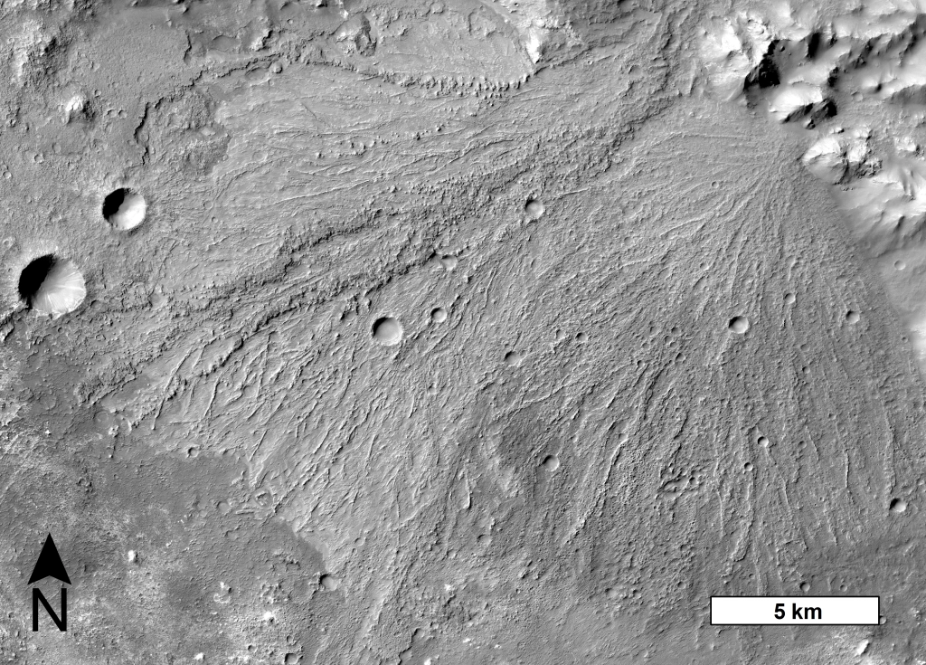
During the last few decades, dry river valley networks and delta fan structures have been found to be increasingly common on ancient terrains on the martian surface (e.g. Goldspiel and Squyres, 1991; Hynek et al., 2010). They are considered to be one of the main lines of evidence that Mars once had Earth-like precipitation and surface runoff (e.g. Hynek and Phillips, 2003). One such location is the south-western Melas basin, part of a collapsed graben structure on the southern wall of Melas Chasma, Valles Marineris – Mars’ equatorial canyon system (Images 1 & 2). The basin likely formed in the early Hesperian period (~ 3.7 – 3.5 Ga), soon after Melas Chasma opened.
Image 1: Context Camera image-mosaic of western portion of palaeolake sequence in the south-western Melas basin. In the left of the image, valley networks can be seen converging on a delta-like structure at the centre of the image. Layered lacustrine deposits are well exposed in the right of the image; about 40-50 packages are visible at this resolution. [Image numbers: G22_026866_1710_XN_09S077W & P07_003685_1711_XI_08S076W]
Gullies on Mars were first discovered in 2000 (Malin and Edgett, 2000) in images taken by the Mars Orbiter Camera on board NASA’s Mars Global Surveyor platform. They are kilometre-scale features and have a striking resemblance to water-carved gullies on Earth (Image 1).
Image 1: Example of gully morphologies on Mars in HiRISE data. Image credits: NASA/JPL/UofA. (a) Gullies on the wall of a small impact crater within Kaiser crater, image number: PSP_003418_1335. (b) gullies within a polar pit, image number: PSP_003498_1090. (c) Gullies on the wall of Galap crater, near Sirenum Fossae, image number: PSP_003939_1420 (d) Gullies on the wall of Wirtz crater, a large impact crater to the east of Argyre basin, image number: PSP_002457_1310 (e) Gullies on the slip face of dunes in Russell Crater in Noachis Terra, image number: PSP_001440_1255 (f) Gullies on the wall of an impact crater to the west of Newton Crater in Terra Sirenum, image number: PSP_005930_1395.
Post contributed by Dr Andreas Johnsson, Department of Earth Sciences, University of Gothenburg, Sweden.
The question whether Martian gullies formed by fluvial processes or by dry mass wasting have been a source of heated debate ever since their discovery (Malin and Edgett, 2000). Intense research within the last decade however points to a fluvial origin for a majority of gully landforms on Mars.
Image 1. A) Overview of the pole-facing interior crater wall (PSP_006837_1345). B) Clearly defined paired levee deposits (white arrows). C) Multiple overlapping lobate deposits (white arrows). D) Gully fan dominated by debris flows (white arrows). E) Well defined medial deposit (debris plug) (white arrow). Image credit: NASA/JPL/UofA for HiRISE.
A group of Martian craters formerly contained lakes, some of which overtopped and breached the crater rims to cause flooding and channel erosion.
Image 1: View of Morella Crater and the complex of Elaver Vallis channels eroded by floodwaters released when the crater rim was breached. The distal reaches of Elaver Vallis were obliterated by the southward expansion of Ganges Chasma, which is 5 km deep. The chasma as seen today did not exist during the Elaver flood, otherwise high groundwater pressures would have been relieved by breakouts in the walls and floor of the chasma [graphic is a mosaic of THEMIS daytime infrared (IR) images].
Post by Samantha Peel Department of Earth and Planetary Sciences, University of Tennessee, USA.
Central pit craters are a crater type that contain an approximately circular depressions in their floor or central peak (Image 1). These craters have been found on Mars, Ganymede, and Callisto (e.g., Barlow, 2010; Alzate and Barlow, 2011; Bray et al., 2012). On Mars, a subset of central pit craters has been found to contain valleys that terminate in central pits (Peel and Fassett, 2013). These “pit valleys” are believed to have formed as ancient rivers transported water and sediment to the central pits.
Image 1: Mosaic of three MRO CTX images (B18_016770_1429_XI_37S201W, B19_017192_1443_XI_35S202W, B19_016981_1432_XN_36S201W) showing the interior of a well-preserved central pit crater with pit valleys. The crater is located at 36.30ºS, 158ºE.
Posted by Jan Raack, Institut für Planetologie, WWU Münster, Germany
Image 1: Smooth appearing atmospherically derived dust-ice mantle on a south-west facing mountain slope. The flow direction of the gullies is from north to south. The gullies only erode the dust-ice mantle; the underlying bedrock was not substantially eroded. A modified dust-ice mantle indicates as viscous flow features(black arrows) are visible at the termini of the aprons. Subscene of CTX-image P05_003170_1331_XI_46S050W
Gullies are erosional-depositional landforms consisting of a source area (alcove), channel and apron. They occur primarily on mountain slopes and on crater walls on Mars. Morphologic attributes such as braided channels, point bars, and cut banks in many gullies suggest that fluvial processes were involved in their formation. The most plausible agent to form gullies is liquid H2O (groundwater seepage, melting of near surface ice and snow, or melting of a dust-ice layer on the surface). Alternative gully formation processes on Mars include the sublimation of CO2 or dry granular flows. Gullies have a wide range of ages and age determinations by crater size-frequency distribution measurements (a method used in planetary science to date surfaces via the size and frequency of impact craters) show that gullies on Mars were active in the past few million years. (more…)
Post by Joe Levy, Department of Geological Sciences, University of Texas, Austin, Texas, USA
Water tracks are zones of enhanced soil moisture that route shallow groundwater downslope in permafrost regions. Water tracks form in the active layer (the seasonally thawed portion of the permafrost) where melt water derived from snow-melt, ground ice melt, and exotic processes like salt deliquescence, concentrates in broad depressions in the ice table (the part of the permafrost that remains frozen) and flows downhill. Water tracks darken and lengthen during the summer melt season, and freeze-dry in winter, rendering them nearly undetectable from late fall to early spring.
Image 1. Quickbird satellite image of a water track in the vicinity of Lake Hoare, McMurdo Dry Valleys, Antarctica. Near-surface groundwater flows downhill from the top of the image towards the ice-covered pond at the bottom. Portion of Quickbird image orthowv02_10dec222046120-p1bs-103001000825e900_u08ns4326.
Post by Dr Mirjam Langhans, Istituto di Astrofisica Spaziale e Fisica Cosmica – INAF, Roma, Italy
Saturn‘s largest moon Titan is one of only a few bodies in the Solar System with an active volatile cycle. Besides Earth, only ancient Mars is supposed to have hosted a water cycle. Titan‘s volatile cycle is based on methane (CH4), occurring in liquid and gaseous state given Titan‘s environmental conditions (e.g. Flasar 1983, Lorenz & Lunine 2005). Despite the different volatiles involved, similar atmospheric processes occur on Titan and Earth, such as the formation of clouds and precipitation .
Following the action of the methane cycle, surface runoff and the incision of linear valleys take place. As a result, fluvial landscapes evolved on Titan, analog to those on Earth (e.g. Tomasko et al. 2005; Perron et al. 2006, Lorenz et al. 2008, Langhans et al. 2012).
Image 1: Cassini-Radar-SAR image shows a dendritic valley network at high northern latitudes of Titan, ending in Kraken Mare, captured by radar-SAR (Radar-SAR T28, April 10, 2007). The image is centered at 280°W, 78°N.
Hale crater is a 125×150 km impact crater located near the intersection of Uzboi Vallis and the northern rim of Argyre basin on Mars, at 35.7ºS, 323.6ºE. Hale is an unusual crater on Mars because it is modified by fluvial channels. The channels originate from the outer edges of Hale’s ejecta and extend as far as 460 km from the crater rim (Image 1). They are upto a few kilometers wide, exhibit a braided planform (Image 2), and had sufficient stream power to incise and transport the crater ejecta. Most of the channels are found to the south-southwest of Hale crater, on the northern slope of Argyre basin (Image 3).
Image 1: Channels in the southeastern ejecta of Hale crater, Mars in a THEMIS daytime-infrared mosaic. The channels were likely carved with water mobilized by the Hale-forming impact event. White box is location of Image 2. North is up in all images.
Image 2: Detailed view of fluvial channel flowing through crater ejecta. CTX image Location is shown in Image 1.
Post by Devon Burr1, Sarah Drummond1 and Robert Jacobsen2.
1Earth and Planetary Sciences Department and Planetary Geosciences Institute, University of Tennessee Knoxville, USA 2Geology Department, Colorado College, USA
Titan, like Earth, has a solid surface enveloped by a substantial atmosphere. Both atmospheres contain a few mass percent of volatiles – hydrocarbons on Titan, water on Earth – that are close to their triple points. These conditions are conducive to precipitation and runoff, resulting in fluvial processes. At Titan, data from the Cassini-Huygens mission indicate the occurrence of methane rainfall and precipitation runoff [Lunine et al., 2008]. In addition, the Descent Imager and Spectral Radiometer (DISR) on the Huygens probe observed branched lineations interpreted as fluvial valley networks with inset streams formed by flowing methane [Tomasko et al., 2005; Perron et al., 2006].
Image 1: Network patterns (Howard, 1967). The implications of some of these patterns are provided in Table 1.
Posted by Goro Komatsu, International Research School of Planetary Sciences, Pescara, Italy.
Subaqueous bedforms produced by catastrophic floods are often represented by gravel dunes (also known as “giant current ripples”). While they may resemble aeolian dunes in remote sensing data, field observation reveals that they are composed of coarse-grained sediment including up to meter-scale boulders. Such examples are widely known in the Channeled Scabland (Baker, 1982) in North America, in Altai (Carling et al., 2002) and Sayan (Komatsu et al., 2009) mountain provinces of Siberia (e.g., Images 1 and 2).
Image 1: Gravel dune fields near Kyzyl, capital city of Tuva, along the Yenisei River, Sayan Mountains, Siberia. Gravel dune fields are commonly positioned at the lower end of alluvial fans emanating from nearby massifs, implying that at least some sediments were locally derived from the fans. They are also located downstream of topographic constrictions, indicating that floodwater conditions had to change along its route for their formation. Image is approximately 5 km wide. From Komatsu et al. (2009).
Alluvial fans are sedimentary deposits that accumulate where streams emerge from steep mountain watersheds onto low-gradient plains. Flooding in the upland area transports a wide range of sediment sizes, and when the stream emerges onto the plain, it no longer has the power to transport the same quantity and size of sediment. Only part of an alluvial fan’s width is active at any one time, but as sediment accumulates in that area, flows will move to steeper routes elsewhere on the fan surface. Sediment may be delivered through normal stream flows or debris flows, which are concentrated slurries of sediment and water. Alluvial fans that were formed mostly by debris flows are usually steeper than their stream-dominated counterparts.
Holden Crater, Mars Image 1: Holden crater (26°S, 34°W) in a Thermal Emission Imaging System (THEMIS) daytime infrared mosaic (230 m/pixel) colored with Mars Orbiter Laser Altimeter topography. Warm colors are high elevations, cool colors are low, and contour lines mark each 50 m interval of elevation. The green-shaded deposits along the western wall of the crater are the Holden bajada.
The High Resolution Stereo Camera (HRSC) on board the Mars Express has a large swath and high resolution [Jaumann et al. 2007]. This enables the capture of large geomorphic features while retaining the ability to track small-scale features over long distances. The HRSC has observed all of the giant outflow channels on Mars. They are supposed to be eroded fluvially as a consequence of the catastrophic release of water [Baker et al., 1992]. Most of them emanate from chaotic terrain [Sharp, 1973], which is heavily collapsed terrain and assumed as their source region. Outflow channels give insight to a different Martian climate with respect to hydrological conditions that apparently were different in the Late Hesperian or Amazonian, when they were formed [Tanaka, 1986].
Image 1: In this image we can see the Mangala Vallis outflow channel at 11.5S/151W.
The Nili Fossae region of Mars has a diversity of minerals that include mafics and phyllosilicates. The mineral assemblage suggests widespread liquid water activity and a variety of alteration processes from surface weathering to hydrothermal processes (Mangold et al., 2007).
Image 1: CRISM infrared spectrometer data (wavelengths: 2.38 um (red), 1.80 um (green), 1.15 um (blue) acquired at 35 m/pixel have been used to colorize a Context Imager grayscale image, taken at 5 m/pixel resolution.
Inversion of relief is a common attribute of landscape evolution and can occur wherever materials in valley bottoms are, or become, more resistant to erosion than the adjacent valley slopes.
Sinuous ridge, Utah, Earth Image 1: An oblique aerial photograph of a carbonate-cemented, sinuous inverted paleochannel segment located approximately 11 kilometers southwest of Green River, Utah.


![Image 1: View of Morella Crater and the complex of Elaver Vallis channels eroded by floodwaters released when the crater rim was breached. The distal reaches of Elaver Vallis were obliterated by the southward expansion of Ganges Chasma, which is 5 km deep. The chasma as seen today did not exist during the Elaver flood, otherwise high groundwater pressures would have been relieved by breakouts in the walls and floor of the chasma [graphic is a mosaic of THEMIS daytime infrared (IR) images].](https://planetarygeomorphology.files.wordpress.com/2014/03/image-1.jpg?w=600)