Active gullies on Mars

Post by Dr. Colin Dundas, U.S. Geological Survey, Astrogeology Science Center

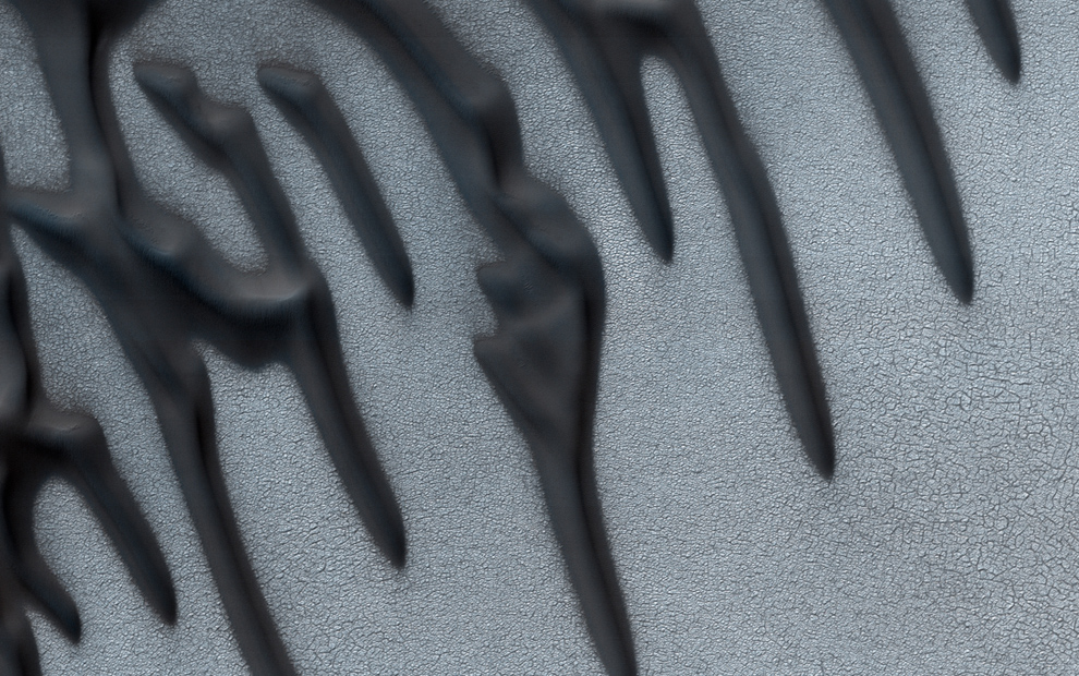
Martian “gullies” are a class of landforms on steep slopes, characterized by an upper alcove and a depositional apron, linked by a channel. On Earth, similar features would likely be termed ravines or alluvial fans. The Martian features usually appear geomorphically fresh, with sharply defined channels and no superposed impact craters. Changes were first detected in Martian gullies over a decade ago, and such observations have become more common as high-resolution repeat image coverage has expanded. This current activity correlates with seasonal frost (which is mostly CO2 on Mars) and has resulted in substantial modification of some gullies, leading to a debate over whether CO2 alone is sufficient to form them without liquid water.

PGIM_Jan2018_Fig1

Image 1: Subsection of HiRISE image ESP_023809_1415 (https://www.uahirise.org/ESP_023809_1415) at reduced resolution, providing context and an overview of the gully system. North is up and light is from the upper left.
(more…)

Creepy stuff – possible solifluction on Mars

Post contributed by Andreas Johnsson, Department of Earth Sciences, University of Gothenburg, Sweden.

Small-scale lobes on Mars (Fig. 1) are tens to hundreds of meters wide and consist of an arcuate frontal riser that is a meter to meters in height and a tread surface (Johnsson et al., 2012) (Fig. 2). The riser is often, but not always, outlined by clasts visible at HiRISE resolution (50-25 cm/pixel; McEwen et al., 2007). They are found on crater slopes in the martian middle and high latitudes in both hemispheres (e.g., Gallagher et al., 2011; Johnsson et al., 2012; 2017) .

Figure 1

Figure 1. Subset of HiRISE image PSP_008141_2440 (lat: 63.78°N/long: 292.32°E) showing multiple clast-banked lobes in an unnamed 16-km diameter crater (white arrow). Note the degraded gully system (black arrows) and lobes inside the alcove area.

(more…)

Small martian landslides – are they similar to large landslides on Earth?

Post contributed by Susan J. Conway and Anthony Guimpier, CNRS Laboratoire de Planétologie et Géodynamique à Nantes, France.

Landslides have been documented on almost all the solid bodies of the solar system and Mars is no exception. The most famous landslides on Mars are the giant landslides in the Valles Marineris, which were discovered in the images returned by the first Mars Orbiter “Mariner 9” launched in 1971 (Lucchitta, 1979). They have volumes typically ranging from 108-1013 m3 (McEwen 1989; Quentin et al. 2004; Brunetti et al. 2014) and have been found to have occurred periodically since the canyon’s formation 3.5 billion years ago (Quantin et al. 2004). The largest size of terrestrial landslides generally only extends to 108 m3 (McEwen 1989; Quentin et al. 2004).

bothLandslides3d

Image 1: Oblique views of small landslides on Mars. Top: Landslide in Chyrse Choas in HiRISE image PSP_005701_1920 draped over 2 m/pix elevation model. Crater just in front of the landslide is 70 m in diameter and the landslide from crest to toe spans 900 m in elevation. The largest boulders are nearly 40 m in diameter. Bottom: Landslide in Capri Chasma in HiRISE image ESP_035831_1760 draped over 2 m/pix elevation model. Crater on slope is 270 m across and the landslide from crest to toe spans ~1 km of elevation. The largest boulders are just over 30 m in diameter.

(more…)

A Wunda-full world? Carbon dioxide ice deposits on Umbriel and other moons of Uranus

Post contributed by Dr. Mike Sori, Lunar and Planetary Laboratory, University of Arizona

Uranus and its moons have only ever been visited by one spacecraft, Voyager 2, which flew by the system in 1986.  One of its large moons, Umbriel, was found to have a mysterious bright ring 80-km-wide inside a 131-km-diameter crater named Wunda.  Image 1 shows Umbriel and this annulus-shaped feature.


Image 1 blog post

Image 1: Voyager 2 image 1334U2-001 showing the Uranian moon Umbriel; note the bright ring inside the crater Wunda at top of the image (which is at Umbriel’s equator).

(more…)

Pit chains on Enceladus

Post contributed by Dr. Emily S. Martin, Research Fellow, Center for Earth and Planetary Studies, National Air & Space Museum, Smithsonian Institution.

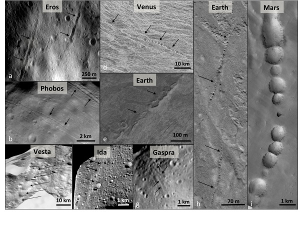
Pit chains are linear assemblages of circular to elliptical pits and have been observed across the solar system. Pit chains have been found on Venus, Earth, Mars, Phobos, Eros, Gaspra, Ida, and Vesta. Across the solar system, pit chains may form through a variety of mechanisms including the collapse of lava tubes, karst, venting, extensional fracturing, or dilational faulting. Saturn’s tiny icy moon Enceladus is the first body of the outer solar system on which pit chains have been identified. Enceladus is only 500 km in diameter and is best known for its warm south pole and its watery plume emanating from prominent ridges known as tiger stripes. The source of the plume is likely a global liquid water ocean beneath an icy shell.

Image1

Image 1: The morphology of pit chains across the solar system. a. Eros from NEAR. Image no. 135344864. b. Phobos. Image PIA10367. c. Albalonga Catena, Vesta. d. Venus. Right-look Magellan data near 13°S, 112°E. e. Kilauea Volcano, Hawaii centered at 19.3909°N 155.3076°W. Image taken 12/06/2014, acquired from Google Earth on 04/20/2016. f. Ida, modified from image PIA00332. g. Gaspra, modified from Galileo image PIA00332. h. Pit chains in north-eastern Iceland centered near 65.9902°N and 16.5301°W. Image taken on 7/27/2012, acquired from Google Earth 04/20/2016. i. Pit chains on Mars from the Mars Global Surveyor Mars Orbiter Camera, centered near 6.5398°S and 119.9703°W on the flank of Arsia Mons. Image PIA02874.

(more…)

Global stereo topography of Jupiter’s moon Io

Post contributed by Oliver White, Search for Extraterrestial Intelligence Institute.

Io is the innermost Galilean satellite of Jupiter, and with over 400 active volcanoes, it is the most volcanically active body in the Solar System, a consequence of tidal heating from friction generated within its interior as it is pulled between Jupiter and other Galilean satellites. Constant volcanic resurfacing means that the oldest surface is likely not more than a million years old (Williams et al., 2011). No instrumentation specifically designed to measure topography has ever been deployed to Io, but White et al. (2014) constructed a global digital elevation model (DEM) covering ~75% of Io’s surface from all available stereo coverage in Voyager and Galileo imaging, and controlled it using Galileo limb profiles (Image 1). This map represents a continuous topographic dataset that has revealed topographic variations not otherwise apparent in Voyager and Galileo imaging and limb profiles, and which may be correlated with geologic units (e.g. Williams et al., 2011). While not providing coverage across the entire globe, the map stands as the most comprehensive continuous topographic data set of Io’s surface, at least until a spacecraft arrives at Io with a dedicated photogrammetric camera or a laser altimeter on board.

Image1

Image 1: Global stereo DEM overlain on a mosaic of Voyager and Galileo images in simple cylindrical projection at
2 km/pixel. Gaps in the DEM represent masked noise or absence of stereo coverage. A broad smoothing filter has been applied to the plains areas of the DEM post-mosaicking but not to comparatively high relief features such as mountains, layered plains, and some paterae (volcanic craters). The width of the map at the equator is 11,445 km.

(more…)

Terraced Craters Reveal Buried Ice Sheet on Mars

Post contributed by A.M. Bramson, Lunar and Planetary Laboratory, University of Arizona

When an object impacts into layered material, it can form a crater with terraces in the crater’s walls at the layer boundaries, rather than the simple bowl-shape that is expected. The shock wave generated by the impact can more easily move the weaker material and so the crater is essentially wider in that layer, and smaller in the underlying stronger material. From overhead, these concentric terraces give the appearance of a bullseye. Craters with this morphology were noticed on the moon back in the 1960s with the terracing attributed to a surface regolith layer. More recently, numerous terraced craters have been found across a region of Mars called Arcadia Planitia that we think is due to a widespread buried ice sheet.


Bramson_IAG_1
Image 1: A terraced crater with diameter of 734 meters located at 46.58°N, 194.85°E, in the Arcadia Planitia region of Mars. This 3D perspective was made by Ali Bramson with HiRISE Digital Terrain Model DTEEC_018522_2270_019010_2270_A01. Using this 3D model, we were able to measure the depth to the terraces, and therefore the thicknesses of the subsurface layers that cause the terracing.

(more…)

The subsurface as the key to surface on Martian gullies

Post by Dr. T. de Haas, Department of Geography, Durham University.

Martian gullies are composite landforms that comprise an alcove, channel and depositional fan. They are very young geological features, some of which have been active over the last million years. Water-free sediment flows, likely triggered by CO2 sublimation, debris flows, and fluvial flows have all been hypothesized to have formed gullies. These processes require very different amounts of liquid water, and therefore their relative contribution to gully-formation is of key importance for climatic inferences. Formative inferences based on surface morphology may be biased however, because of substantial post-depositional modification (Images 1-3).

Image1

Image 1: Morphometry, morphology and stratigraphy of depositional landforms in Galap crater. (a) Overview and digital elevation model of Galap crater. (b) Detail of northwestern slope showing gradients of catchment and depositional fan. (c) Detail of proximal fan surface. (d) Detail of distal fan surface. (e) Detail of fan surface with incised channels; the dashed line indicates the rockfall limit. (f) Example of stratigraphic section. (h) Same stratigraphic section as in f, but with optimized contrast in the section. Arrows denote downslope direction. HiRISE image PSP_003939_1420.

(more…)

Cryovolcanic flows on Ceres

Post contributed by Dr. Katrin Krohn, German Aerospace Center, Institute of Planetary Research

The dwarf planet Ceres is a weakly differentiated body with a shell dominated by an ice-rock mixture and ammoniated phyllosilicates, which has a variety of flow features visible on its surface. Flow features are common features on planetary surfaces and they indicate the emplacement of viscous material. Many of the observed flows on Ceres originate from distinct sources within crater interiors and on crater flanks.

Haulani_IAG

Image 1: LAMO FC mosaic of Haulani crater. A: Well-defined smooth lobes (LAMO FC21A0049392_16002071420F1F.IMG). B: Multiple flow stages on western crater flank (FC21A0046469_15350155540F1C.IMG).

(more…)

Sedimentary basins on Mars, they contain a lot more sediments than we thought!

Post contributed by Dr. Francesco Salese, Italian Space Agency

The nature of the early Martian climate is one of the major unanswered questions of planetary science. To date the geologic evidence that Mars once had large amounts of surface liquid water is conclusive, but geomorphic constraints on the duration for which that water flowed are much weaker. In addition, much of the geochemical evidence points towards surface conditions that were not warm and wet for long time periods. The evidence points towards a hydrological cycle that was intermittent and not permanently active 3.8 billion years ago. However, in a recently published article myself and colleagues report that flowing water and aqueous environments formed thick, widespread sedimentary plains 3.8 billion years ago in the northern rim of the Hellas basin on Mars.

image1

Image 1: 3D view of the northern Hellas plains, including hills, plains, erosional windows, and impact craters with their interpreted lithology. Mosaic of CTX images draped on MOLA topography.

(more…)

Seismo-tectonic geomorphology of the Moon: Lobate scarps and boulder falls

Post contributed by P. Senthil Kumar, CSIR-National Geophysical Research Institute, Hyderabad, India

Geomorphology of terrestrial planets provides important insights into how various exogenous (e.g., meteorite impact, wind activity, glaciation) and interior geological processes (e.g., tectonics, volcanism) interact with the planetary surface. The tectonic features (faults, folds and fractures) shed light on the past and on-going seismo-tectonic processes operating on a planetary body. On Earth, seismometer networks are used in the direct instrumental observations of earthquake locations and their sizes for many decades. For other planets, seismic observations are rare. On the Moon, Apollo seismometers recorded moonquakes only during a brief period of 1969-1976. Annually, about 2000 deep moonquakes originating at 800-900 km depth, tens of shallow moonquakes at 0-100 km depth and around 200 meteoroid impacts were observed (Nakamura et al., 1979; Nakamura, 1980). While the deep moonquakes are produced by tidal forces, the sources of shallow moonquakes are thought to be of tectonic in origin. However, crustal tectonic structures responsible for shallow moonquakes are poorly understood.

post_pgwg_senthil_figure_27feb2017

Figure 1: (upper panel) LROC NAC images showing the en echelon pattern of a lobate scarp, located near the southern basin wall of Schrodinger basin. Hundreds of boulder falls and their trails are found on the basin wall about 5-7 km south of the lobate scarp. The boulders are shown as points (open circles filled with yellow) and are not to the scale. Note the largest number of boulder falls is seen between 129° and 130° longitudes. (lower panel) LROC NAC (M139078014RE) image showing the boulder trails of variable lengths and widths containing some prominent boulders at the terminal ends of the trails. A 23 m diameter boulder (labelled), the largest in this scene, produces a trail (also labelled) slightly wider than the boulder indicating a possible size reduction during its transport from the source region to its current location. Most boulder trails criss-cross each other.

(more…)

Everything you wanted to know about martian scoria cones, but were afraid to ask…

Post contributed by Dr. Petr Brož, Institute of Geophysics of the Czech Academy of Science

Volcanism is an important process which shapes the surfaces of all terrestrial planets, and is still active on Earth, Jupiter’s moon Io, and perhaps on Venus. On Earth, volcanoes with wide variety of shapes and sizes exist; however, the size of volcanoes is anti-correlated with their frequency, i.e. small volcanoes are much more numerous than large ones. The most common terrestrial volcanoes are represented by kilometre-sized scoria cones (Figure 1a). These are conical edifices of pyroclastic material originating from explosive volcanic activity. Degassing of ascending magma causes magma fragmentation on eruption piling up the pyroclasts around the vent as a cone. Interestingly, scoria cones as known from Earth, have not been observed commonly on any other terrestrial body in the solar system despite the fact that magma degassing, and hence magma fragmentation, has to occur on these bodies as well.

figure_1

Figure 1: Example of a terrestrial scoria cone (panel a, Lassen Volcanic National Park, California, photographed by the National Park Service) and its putative martian analogue (panel b, detail of CTX image P22_009554_1858_XN_05N122W).

(more…)

The book of landforms

Post contributed by Henrik Hargitai, NASA Ames and ELTE, Hungary

Everyone has a story. The narrative of who we are is created by us, our actions and interactions, sometimes just drifting with the events we live through. Landscapes like the one shown in Image 1, tell a geologic story. We translate it to human language and categories. Landscapes are the interface between a planetary body, its atmosphere and the cosmic environment. They change, age, and renew. A flood from a distant source, an impact, settling dust, all imprint onto it. Its history is recorded in its materials and its relief. With age, it depicts an ever more complicated story until resurfacing destroys its history. It’s increasingly popular to explain geology by processes. In real life, however, processes are not always clear cut and as we enter the age of multidisciplinary studies, many of us accept people who are different, we also recognize that landforms are shaped by a multitude of processes, they are not black or white, but all shades of… any color. Is a channel volcanic or fluvial? Well, maybe it’s both, and tectonic, too, with a pinch of ice-rich material that is of course sublimating. Even the types of question we can think of evolve, and this is happening in science, humanities and politics in parallel. Lowell’s Mars? Flat plains and marshes. Perhaps he didn’t even have enough creativity? Nature ‘s creativity always surpasses our own.

image1

Image 1: The terminus of an inferred lava flow in one of the Marte Vallis outflow channels at 17.94 N, 185.51 E (Keszthelyi et al. 2008) (CTX image P03_002027_1979, credit NASA/JPL/MSSS)

(more…)

The Geomorphology of Potential Mars Tsunami Deposits

Post by Dr. Alexis Rodriguez. Planetary Scientist, Planetary Science Institute, Tucson, AZ, USA.

The Martian northern lowlands are thought to currently be extensively covered by an ice-rich deposit, interpreted by some researchers to be the residue of an ancient ocean that existed ~3.4 Ga (Kreslavsky and Head., 2002). However, evidence for this ocean has remained a subject of intense dispute and scientific scrutiny since it was first proposed (Parker et al., 1989, 1993) several decades. The controversy has largely stemmed in the fact that the proposed Martian paleo-shoreline features exhibit significant elevation ranges (Head et al., 1999), a lack of wave-cut paleoshoreline features (Malin and Edgett, 1999), and the presence of lobate margins (Tanaka et al., 1997, 2005).

image_1

Fig. 1. Left: Color-coded digital elevation model of the study area showing the two proposed shoreline levels of an early Mars ocean that existed approximately 3.4 billion years ago. Right: Areas covered by the documented tsunami events extending from these shorelines. Lead author Alexis Rodriguez created this figure.

(more…)

It is Mercury’s fault(s)…

Post contributed by Valentina Galluzzi, INAF, Istituto di Astrofisica e Planetologia Spaziali (IAPS), Rome, Italy

Any celestial body that possesses a rigid crust, be it made of rock (e.g. terrestrial planets, asteroids) or ice (e.g. icy satellites), is subject to both endogenic and exogenic forces that cause the deformation of crustal materials. As a result of the mass movement, the brittle layers often break and slide along “planes” commonly known as faults. In particular, tensional, compressional and shear forces form normal, reverse and strike-slip faults, respectively. On Earth, plate tectonics is the main source of these stresses, being a balanced process that causes the lithospheric plates to diverge, converge and slide with respect to each other. On Mercury, there are no plates and therefore the tectonics work differently. Instead its surface is dominated by widespread lobate scarps, which are the surface expression of contractional thrust faults (i.e. reverse faults whose dip angle is less than 45°) and this small planet is in a state of global contraction.

image1

Image 1. Endeavour Rupes area on Mercury, image is centred at 37.5°N, 31.7°W. Top: MESSENGER MDIS High-Incidence angle basemap illuminated from the West (HIW) at 166 m/pixel. Bottom: MESSENGER global DEM v2 with a 665m grid [USGS Astrogeology Science Center] on HIW basemap, the purple to brown colour ramp represents low to high elevations, respectively. Endeavour Rupes scarp is high ~500 m. For scale, Holbein crater diameter is approximately 110 km.

(more…)

Kārūn Valles and its braided alluvial fan

Post contributed by Solmaz Adeli, Deutsches Zentrum für Luft- und Raumfahrt (DLR), Institute of Planetary Research, Berlin, Germany

Image1.jpg

Image 1: Kārūn Valles located on the rim of the Ariadnes Colles basin. The visible channel head and deep grooves are shown (detail of CTX image D10_031182_1435). (b) The Kārūn Valles alluvial fan. Note the elongated depositional bars and their wide distribution. (c) A zoom on one of the braided bars. The flow direction is indicated by dashed arrows (detail of HiRISE image ESP_043261_1440).

The Amazonian period on Mars, meaning roughly the last 3 Ga, is globally believed to have been cold and hyperarid [e.g., Marchant and Head, 2007]. Recent geomorphological observations, however, have revealed the presence of well-preserved Amazonian-aged fluvial valleys in both the north and south mid-latitude regions of Mars [Howard and Moore, 2011; Hobley et al., 2014; Salese et al., 2016; Wilson et al., 2016]. These features point to one or several climate change phase(s) during Amazonian which could have sustained liquid water at the martian surface. These climate changes could have been triggered by obliquity oscillations [Laskar et al., 2004] causing the transportation of ice from polar regions and its re-deposition at lower latitudes. Episodic melting events during Amazonian, subsequently, formed valleys and other fluvial features, in the mid-latitude regions.

(more…)

Water, water, everywhere…?

Post contributed by Dr. Susan J. Conway CNRS and LPG Nantes, France

The similarity of water-formed landforms on Earth is often used as a key argument for the involvement of liquid water in shaping the surfaces of other planets. The major drawback of the argument is “equifinality” whereby very similar looking landforms can be produced by entirely different processes. A good illustration is leveed channels with lobate deposits (Image 1). Such landforms can be built on Earth by wet debris flow, lava flow, pyroclastic flows and they are also found on Mars (de Haas et al., 2015; Johnsson et al., 2014) where the formation process is debated.

lobesOfDifferentKinds_IAG_IOTM

Image 1: Lobes and levees, scale bars are 50 m in all cases. Wet debris flow deposits in Svalbard, image credit DLR HRSC-AX campaign. Lava flows on Tenerife, aerial image courtesy of IGN, Plan Nacional de Ortofotografía Aérea de España. Self-channelling pyroclastic deposits at Lascar volcano, Chile, Pleiades image. Depositional lobes in Istok crater on Mars, HiRISE image PSP_007127_1345.

(more…)

Large aeolian ripples on Mars

Post contributed by Dr. Ryan C. Ewing, Department of Geology and Geophysics, Texas A&M University

Ripples cover the surfaces of sand dunes on Earth and Mars. On Earth, ripples formed in typical aeolian sand (e.g., 0.1 and 0.3 mm) range in wavelength between 10 and 15 cm and display a highly straight, two-dimensional crestline geometry. Ripples are thought to develop through a process dominated by the ballistic impacts of saltating sand grains in which wavelength selection occurs through the interplay of grain size, wind speed, the saltation trajectories of the sand grains, and ripple topography.

2d_ripples_DeathValley

Figure 1: Wind-blown impact ripples from Mesquite Flat Sand Dunes, Death Valley, USA. Pen is ~15 cm. Inferred transport direction is to the right on the image. Image credit: Ryan C. Ewing

(more…)

Debris-Covered Glaciers on Earth and Mars

Post contributed by David P. Mayer, Department of Geophysical Science, the University of Chicago

Debris-covered glaciers are glaciers whose ablation zones are at least partially covered by supraglacial debris. On Earth, debris-covered glaciers are found in all major mountain glacier systems. The debris itself is primarily derived from rockfall above the accumulation zone. This material becomes entrained in the accumulating ice and is carried englacially before emerging in the ablation zone. On Mars, numerous mid-latitude landforms have been interpreted as debris-covered glaciers based on their geomorphic similarity to nearby ice-rich landforms such as lobate debris aprons (LDA), as well as their similarity to terrestrial debris-covered alpine glaciers (Head et al., 2010 and refs. therein).

Image1_mullins_glacier

Image 1: Aerial photo of Mullins Glacier in Beacon Valley, Antarctica, a debris-covered glacier and possible analog to certain landforms on Mars. USGS aerial photo TMA 3080/275. Available from http://www.pgc.umn.edu/imagery/aerial/antarctica.

(more…)

The surface expression of intrusive volcanic activity on Mars

Post contributed by Peter Fawdon, Dept. of Earth and Planetary Sciences, Birkbeck, University of London, UK.

Volcanism is an important process that can be observed on the surface of many planetary bodies. Not all magma bodies erupt extrusively onto the planet’s surface, many simply stall within the crust, cooling slowly over millions of years to form igneous intrusions. On Earth erosion and uplift expose the frozen core of ancient volcanoes relatively frequently, however, it is considerably more difficult to investigate this intrusive magmatism on other planets.

Figure1

Figure 1 shows a perspective view across Nili Patera. This view is generated in ArcScene using data from a mosaic of three CTX elevation models and orthoimages. The view shows Nili Tholus and the associated bright central lava unit as well as the graben along the top of the uplifted region of the western caldera floor.

(more…)

Martian Maars: valuable sites in the search for traces of past martian life

Post contributed by Dr. Sandro Rossato, Department of Geosciences, University of Padova, Padova, Italy

Fig1

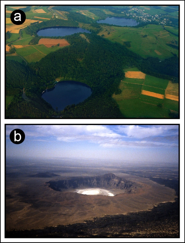
Figure 1: Terrestrial maars. (a) is a group of three maars filled with water in the Eifel region, Germany (rim-to-rim diameter ~0.5-1 km) (“Maare” by Martin Schildgen – Own work. Licensed under CC BY-SA 3.0 via Wikimedia Commons – https://commons.wikimedia.org/wiki/File:Maare.jpg#/media/File:Maare.jpg). (b) shows the Wabah maar, located in Saudi Arabia (rim-to-rim diameter ~2 km) (courtesy of Vic Camp, San Diego State University).

Terrestrial maar-diatremes are small volcanoes (see this previous post for a general description) which have craters whose floor lies below the pre-eruptive surface and are surrounded by a tuff ejecta ring 2-5 km wide (Figure 1) that depends on the size of the maar itself and on the depth of the explosion (Lorenz, 2003). Maar-diatremes constitute highly valuable sites for in situ investigations on planetary bodies, because they expose rocks at the surface from a great range of crustal depths and are sites which could preferentially preserve biomarkers.

(more…)

Sedimentology and Hydrology of an Amazonian paleo-fluivo-lacustrine systems on Mars (Moa Valles)

Post contributed by Francesco Salese from IRSPS/Dipartimento INGEO, Università D’Annunzio, Pescara, Italy.

Mars, is one of the planetary bodies where water flowed and where it may transiently flow today under certain conditions. Many martian paleodrainage systems and well-preserved fluvial and lacustrine deposits have been recognized and studied in the last two decades (see further reading). Widespread dendritic valley networks and the presence of extensive fluvial features on ancient martian terrains suggest that a relatively “warm and wet” climate was prevalent early in the planet’s history (about 3.7 Ga). This is in stark contrast with the hyper-arid, extremely cold climate that is thought to have persisted from 3 Ga until the present (Amazonian Era). The subject of this post is Moa Valles [Salese et al., 2016], which is a 2 billion year old paleodrainage system (Figure 1) that is nearly 300 km long and is carved into ancient highland terrains of Tempe Terra in the northern hemisphere of Mars. Understanding the origin and evolution of this type of complex and interconnected paleo-fluvio-lacustrine system is critical for understanding the early martian climate.

Figure2

Figure 1: The upper panel shows the THEMIS-VIS daytime mosaic of Moa Vallis system.The lower panel is a line drawing showing the channel system in blue lines, red dotted lines represent wrinkle ridges, the drainage basin is delimited in grey, and fan-shaped and deltaic deposits in orange. The total mapped length of the channel as shown here is ~325 km, and the flow direction is towards the east.

(more…)

An esker still physically associated with its parent glacier in Phlegra Montes, Mars

Post contributed by Colman Gallagher, University College Dublin.

Eskers are sinuous ridges composed of deposits (Image 1) laid down from meltwater flowing in tunnel-like conduits beneath glaciers (Image 2). On Earth, eskers are common components of deglaciated landscapes (Image 3) but eskers also can be observed emerging from the margins of intact glaciers.

Image 1

Image 1. A longitudinal section through part of an esker ridge in Ireland. Esker sediments are layered and often extremely coarse. The structures of the layers represent highly variable depositional settings within subglacial meltwater tunnels. The coarse sedimentary calibre represents extremely powerful meltwater flows.

(more…)

Inverted wadis on Earth: analogs for inversion of relief on the Martian surface

Post contributed by Abdallah S. Zaki, Department of Geography, Ain Shams University.

The evolution of inverted topography on Earth and Mars can result from surface armouring of the channel, infilling of channels/valleys by lava flows, and cementation of valley floor by secondary minerals (such as, calcium carbonate, gypcrete, ferricrete, calcrete) – see post by Rebecca Williams. This post specifically concerns inverted wadis, which have been identified in a number of localities on Earth, including multiple localities in the Sahara and Arabia, Australia, the Ebro Basin of Spain, Utah, and New Mexico and west Texas (e.g., Miller, 1937; Maizels, 1987; 1990). Inversion of relief is observed commonly on Mars, for example, Eberswalde Crater, Arabia Terra, Juventae Chasma, Olympus Mons, and Antoniadi Crater (e.g., Pain et al., 2007; Williams et al., 2007).

Image 1

Image 1: Google Earth image of the dendritic pattern preserved in inverted wadis in eastern Saudi Arabia.

(more…)

Salty Flows on Mars!

Post contributed by Lujendra Ojha, Georgia Institute of Technology.

Recurring slope lineae (RSL) are dark, narrow features forming on present-day Mars that have been suggested to be a result of transient flowing water. RSL extend incrementally downslope on steep, warm slopes, fade when inactive, and reappear annually over multiple Mars years (Images 1 and 2). Average RSL range in width from a few meters (<5 m), down to detection limit for the High Resolution Imaging Science Experiment (HiRISE) camera (~0.30 m/pixel). The temperatures on slopes where RSL are active typically exceed 250 K and commonly are above 273 K. These characteristics suggest a possible role of salts in lowering the freezing point of water, allowing briny solutions to flow.

Image1

Image 1: RSL flowing downhill on the steep slopes of Palikir crater in the southern mid-latitude of Mars. Credits: NASA/JPL/University of Arizona.

(more…)

Pluto, Up Close!

Post contributed by Dr Veronica Bray, Lunar and Planetary Laboratory, University of Arizona.

Images of Pluto coming back from NASA’s New Horizons spacecraft have revealed many unexpected landforms and show extreme albedo and compositional variations across the dwarf planet’s surface. This blog post concentrates on one high-resolution swath across the boundary between the cratered terrains of Viking and Voyager Terra and the smoother ices of Sputnik Planum (see Figure 1). Take time to scroll down this long image (Figure 2), that covers ~530 km of Pluto’s surface at around 30°N.

pluto

Figure 1: A global image of Pluto created from high-resolution (2.2km/pixel) panchromatic images from the LORRI instrument and lower-resolution (5km/pixel) colour data from the Ralph/Multispectral Visual Imaging Camera. The colours have been enhanced to show the diversity of the surface units by combining blue, red and near infra red images. Credits: NASA/JHUAPL/SWRI.

(more…)

A Mud Flow on Mars?

Post contributed by Prof. Lionel Wilson, Lancaster University, UK and Dr. Peter J. Mouginis-Mark, Hawaii Institute of Geophysics and Planetology, USA.

Image 1 shows a distinctive flow deposit southwest of the Cerberus Fossae on Mars.  The flow source is a ~20 m deep, ~12 x 1.5 km wide depression within a yardang field associated with the Medusae Fossae Formation.  The flow traveled for ~40 km following topographic lows to leave a deposit on average 3-4 km wide and up to 10 m thick.  The surface morphology of the deposit suggests that it was produced by the emplacement of a fluid flowing in a laminar fashion and possessing a finite yield strength. There is an ongoing debate about whether flows in this region of Mars are lava flows or water-rich debris flows.

Image 1: Location of mudflow deposit on Mars.

Image 1: Location of the distinctive flow deposit, called Zephyria Fluctus, just north of the equator on Mars. The inset at top left shows the broader context of the flow. The grey area is the flow’s extent and black boxes indicating the position of Images 2 and 3 (Fig. 2) and Image 4 (Fig. 4). The inferred flow direction is from SW to NE. Mosaic of CTX images D01_027675_1806, D04_028941_1805 and G19_025697_1803.

(more…)

A cracking comet!

Post contributed by Dr. M. Ramy El-Maarry, Institute of Physics, University of Berne, Switzerland.

The European Rosetta spacecraft went into orbit around comet 67P/Churyumov-Gerasimenko in Aug, 2014. Since then, the spacecraft’s imaging instruments, particularly the OSIRIS camera, have been sending images of the comet’s surface in unprecedented detail showing an amazingly complex landscape and a suite of geomorphological features that suggest many processes are currently at work and acting on the surface.

Image 1: OSIRIS images of various polygonal fracture systems on the surface of the comet.

Image 1: OSIRIS images of various polygonal fracture systems on the surface of the comet.

(more…)

Groundwater outflow on Mars – insights from large-scale experiments

Post contributed by Dr. Wouter Marra, Faculty of Geosciences, Universiteit Utrecht.

There are many water-worn features on the planet Mars, which contribute to the reconstruction of former hydrological conditions. For example, dendritic valley networks show that there was precipitation in the Noachian, the oldest epoch on Mars more than 3.7 billion years ago (Craddock and Howard, 2002). In contrast, fluvial morphologies in younger terrains seem to originate from groundwater (e.g. Baker and Milton, 1974). These are valleys that appear suddenly in the landscape, for example the large outflow channels (e.g. Mangala Vallis and Kasei Vallis) and theatre-headed valleys (such as Nirgal Vallis). However, such systems and their implications are poorly understood. To better understand the formation of such landscapes, I performed several scale-experiments focused on the fundamental process and resulting morphology.

Image 1: Landscapes formed by seepage of groundwater. Left are photos from the experiments, right are examples of Martian cases. Top images show seepage from a distal source, characterized by many small valleys in between large valleys as result of flow convergence to the large valleys. Bottom images have a local source of groundwater, which results in the formation of many valleys of similar size. Arrows indicate (inferred) flow direction. Martian images are from THEMIS daytime infrared.

Image 1: Landscapes formed by seepage of groundwater. Left are photos from the experiments, right are examples of Martian cases. Top images show seepage from a distal source, characterized by many small valleys in between large valleys as result of flow convergence to the large valleys. Bottom images have a local source of groundwater, which results in the formation of many valleys of similar size. Arrows indicate (inferred) flow direction. Martian images are from THEMIS daytime infrared.

(more…)

Valleys, Deltas, and Lacustrine Sediment in the South-western Melas Basin, Valles Marineris, Mars

Post contributed by Joel Davis, Department of Earth Sciences, University College London, UK.

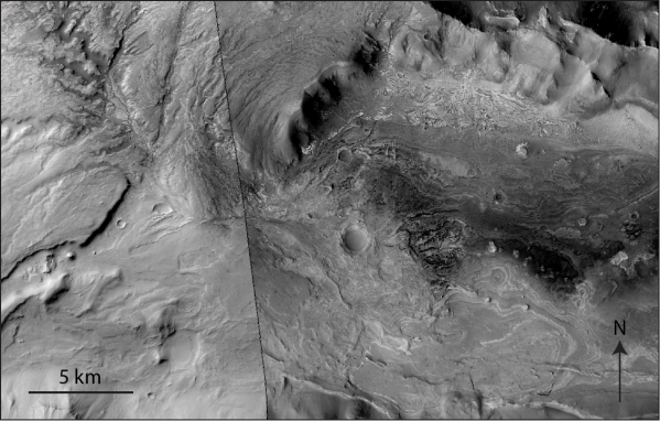
During the last few decades, dry river valley networks and delta fan structures have been found to be increasingly common on ancient terrains on the martian surface (e.g. Goldspiel and Squyres, 1991; Hynek et al., 2010). They are considered to be one of the main lines of evidence that Mars once had Earth-like precipitation and surface runoff (e.g. Hynek and Phillips, 2003). One such location is the south-western Melas basin, part of a collapsed graben structure on the southern wall of Melas Chasma, Valles Marineris – Mars’ equatorial canyon system (Images 1 & 2). The basin likely formed in the early Hesperian period (~ 3.7 – 3.5 Ga), soon after Melas Chasma opened.

Image 1

Image 1: Context Camera image-mosaic of western portion of palaeolake sequence in the south-western Melas basin. In the left of the image, valley networks can be seen converging on a delta-like structure at the centre of the image. Layered lacustrine deposits are well exposed in the right of the image; about 40-50 packages are visible at this resolution. [Image numbers: G22_026866_1710_XN_09S077W & P07_003685_1711_XI_08S076W]

(more…)

Possible Periglacial landscape in Utopia Planitia, Mars

Post contributed by Alex Barrett, Dept. of Physical Sciences, Open University, UK.

The following images show the walls of a two kilometre diameter impact crater in Utopia Planitia on Mars. This region is part of the low lying Northern Plains which have generally flat topography. The main occurrences of steeper hill slopes in this region are impact craters such as the one illustrated below.

Image 1: This image shows the southern wall of a two kilometre diameter impact crater in Eastern Utopia Planitia.

Image 1: This image shows the southern wall of a two kilometre diameter impact crater in Eastern Utopia Planitia. Note that the image has been rotated so that down-slope is towards the bottom of the image. Several rows of lobate structures can be seen on the right hand side of the image. These may be analogous to the solifluction lobes found in periglacial environments on Earth. To the left hand side of the image are several thin lines of metre scale clasts which could possibly be sorted stripes.

(more…)

  • Enter your email address to follow this blog and receive notifications of new posts by email.

  • Io

  • Blog Stats

    • 192,899 hits