Enigmatic Clastic Polygons on Mars

Post by Laura Brooker, Open University, Milton Keynes, UK.

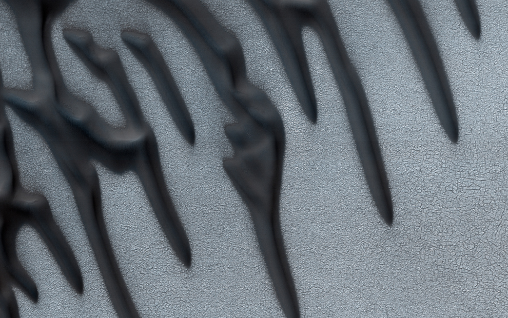
Polygonal ground of centimetre- to decametre-scale is one of the most common features found in cold-climate regions on Earth and on Mars. Polygonal shapes on Earth can form through a number of different processes including the thermal contraction of ice-cemented soils, forming fracture patterns known as thermal contraction polygons, through the freezing and thawing of ground ice moving clasts, in the case of sorted patterned ground, or through the dehydration of volatile-rich material, termed desiccation polygons. Around a large crater found in the northern latitudes of Mars, named Lyot, we observe stunning and unusually large clastic polygons (Image 1), but how do they form? To understand landforms on Mars we turn to analogues on Earth and compare morphological data to look for similarities and differences.

Image 1

Image 1: HiRISE (ESP_016985_2315) image of clastic polygonal ground observed to the north east of Lyot crater, Mars. These enigmatic polygons are demarcated by clastic material in their borders and are averagely 130 metres in diameter. Image credit: NASA/JPL/University of Arizona.
(more…)

Pit chains on Enceladus

Post contributed by Dr. Emily S. Martin, Research Fellow, Center for Earth and Planetary Studies, National Air & Space Museum, Smithsonian Institution.

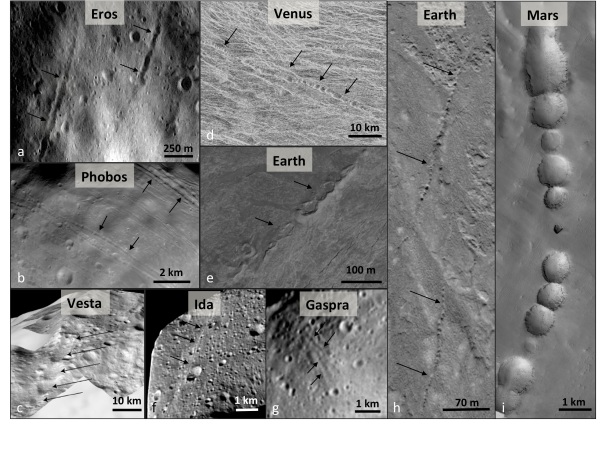
Pit chains are linear assemblages of circular to elliptical pits and have been observed across the solar system. Pit chains have been found on Venus, Earth, Mars, Phobos, Eros, Gaspra, Ida, and Vesta. Across the solar system, pit chains may form through a variety of mechanisms including the collapse of lava tubes, karst, venting, extensional fracturing, or dilational faulting. Saturn’s tiny icy moon Enceladus is the first body of the outer solar system on which pit chains have been identified. Enceladus is only 500 km in diameter and is best known for its warm south pole and its watery plume emanating from prominent ridges known as tiger stripes. The source of the plume is likely a global liquid water ocean beneath an icy shell.

Image1

Image 1: The morphology of pit chains across the solar system. a. Eros from NEAR. Image no. 135344864. b. Phobos. Image PIA10367. c. Albalonga Catena, Vesta. d. Venus. Right-look Magellan data near 13°S, 112°E. e. Kilauea Volcano, Hawaii centered at 19.3909°N 155.3076°W. Image taken 12/06/2014, acquired from Google Earth on 04/20/2016. f. Ida, modified from image PIA00332. g. Gaspra, modified from Galileo image PIA00332. h. Pit chains in north-eastern Iceland centered near 65.9902°N and 16.5301°W. Image taken on 7/27/2012, acquired from Google Earth 04/20/2016. i. Pit chains on Mars from the Mars Global Surveyor Mars Orbiter Camera, centered near 6.5398°S and 119.9703°W on the flank of Arsia Mons. Image PIA02874.

(more…)

  • Enter your email address to follow this blog and receive notifications of new posts by email.

  • Io

  • Blog Stats

    • 192,898 hits