Quantification of ice blockfall activity at a north polar scarp on Mars

Post contributed by Ernst Hauber and Lida Fanara, Institute of Planetary Research, German Aerospace Center (DLR), Berlin, Germany.

Mars is an active planet, and several processes are currently shaping its surface. Among those, gravity-driven mass wasting produces surface changes that can be quantified in image data acquired before and after discrete events. As such changes are typically small in their spatial dimensions, the prime dataset to recognize them are pairs of HiRISE images (High Resolution Imaging Science Experiment; McEwen et al., 2007), with scales of ~25-50 cm/px. The manual identification of surface changes in these huge images (a single HiRISE image can have a size of several Gigabytes) is challenging, however, and requires significant efforts. In order to circumvent this massive demand on human resources while yet taking advantage of all images, automated methods need to be developed. Here we show an example of such methods which was applied to ice block falls at a steep cliff in Mars` north polar region.

PGIM.Figure_01

Image 1: Block fall at a scarp on the north polar region of Mars near 83.796°N and 236.088°E. (a) «before» image acquired at 06 May 2014 (HiRISE image ESP_036453_2640). (b) «after» image acquired at 25 December 2019, showing a cluster of blocks that was displaced from the scarp to the right (east) (ESP_062866_2640). North is up in both images, scale bar is 100 m.
(more…)

Ridged Plains on Europa Reveal a Compressive Past

Post Contributed by Dr. Erin Leonard, Postdoctoral Fellow at the Jet Propulsion Laboratory, California Institute of Technology

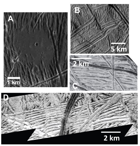
Jupiter’s icy moon Europa has a geologically young surface (60-100 million years old), as evidenced by the sparsity of large impact craters. Studying the surface features on Europa allows insight into how resurfacing may have given it a youthful appearance. The majority of Europa’s young surface is made up of Ridged Plains terrain. This terrain has not been extensively studied before because it appears as a smooth and relatively bland in the global-scale images. However, in the few high-resolution images returned by the Galileo mission in the early 2000s, the Ridged Plains are revealed to consist of numerous ridges and troughs that have a range of morphologies—from crisscrossing each other in various directions to orderly sets of parallel structures (Image 1). But how did these ridges and troughs form?

LeonardFigure1

Image 1: A variety of examples of ridged plains on Europa. Note the linear to curvilinear systematic ridge traces in all examples: (A) observation E4ESDRKMAT02 at 26 m/pixel, (B) observation 19ESRHADAM01 at 66 m/pixel, (C) observation 12ESWEDGE_02 at 29 m/pixel, and (D) observation 12ESMOTTLE02 at 16 m/pixel.

(more…)

Impact Crater Degradation on Mercury

Post by Mallory Kinczyk, PhD candidate, Department of Marine, Earth, and Atmospheric Sciences, North Carolina State University

The formation of impact craters may be the most ubiquitous exogenic surface process in the Solar System. These craters take on many shapes and sizes and can hint at underlying rock types, tell us about the nature of the impactor, and can shed light on the body’s geological history. Even on bodies without atmospheres, erosive forces are at play, changing the crater shape through time via processes such as seismic shaking and disruption from debris thrown outward by subsequent, nearby impacts. Because Mercury is the only terrestrial planet without an atmosphere, it maintains a unique snapshot of the inner Solar System’s impactor population (Image 1) and, in turn, can shed light onto Earth’s own geological history.

converted PNM file

Image 1: View of Mercury from the MESSENGER spacecraft, which orbited Mercury between 2011 and 2015 (Image PIA17280). A variety of impact crater sizes and shapes are evident from very fresh craters to subdued to almost completely obliterated crater forms. Bach crater (arrow) hosts a well-defined central peak ring, but its subdued form indicates that it has been disrupted by subsequent craters. Image Credit: NASA/Johns Hopkins University Applied Physics Laboratory/Carnegie Institution of Washington.

(more…)

Martian elusive Pits and the challenge of working remotely

Post by Dr. Andreas Johnsson, University of Gothenburg, Sweden

Geomorphologists working with Mars share a frustration of not being able to visit their objects of investigation. To counter this, a commonly used approach is to look for environments on Earth that resemble those studied on Mars. This approach, called Earth-analogue studies, helps to guide our line of reasoning in deciphering formation mechanisms of specific martian landforms of interest. Mars, being the most earth-like planet in the solar system hosts numerous landscapes and landforms that in plan-view show remarkable similarities to known features on Earth. Especially striking examples are martian glacial flow-like features and gullies to that resemble terrestrial glaciers and fluvially-incised ravines, respectively. As a consequence their Earth counterparts have been studied with great intensity for the last couple of decades. Although correspondences in form may guide our way of thinking of plausible formative processes by reference to Earth, the approach is not without pitfalls. For example, experimental studies in Mars climate chambers have shown that fluvially triggered slope processes may be of a completely different nature under Mars’ atmospheric conditions of low pressure combined with low temperatures, but the resulting landform looks about the same. This is a problem of equifinality (i.e. convergence of form), something that also terrestrial scientists encounter but which is a major challenge in planetary geomorphology (e.g. Hauber et al. 2011; Zimbelman 2001). One way to try to minimize equifinality is by taking whole landform assemblages into account where different types of landforms may have some genetic linkages.

(more…)

Titan’s dune fields scanned in the microwave: revealing their true nature

Post by Dr. A Lucas, CNRS Research Scientist, Université de Paris, Institut de physique du globe de Paris, CNRS, F-75005, Paris, France

Titan, Saturn’s largest satellite, has proved to be a world that is both strange and yet so familiar to us. Mountains, lakes, drainage systems and dune fields (Images 1-2) cover its surface. Methane on Titan occupies a similar position to water on Earth. It participates in climatic cycles. Moreover, its photodissociation in the upper atmosphere is responsible for the soot rains that fall on the surface of this icy world. The fate of these grains composed of organic materials is just as essential. Indeed, winds sometimes mobilize them. Over long, very long periods of time, this granular transport is responsible for the formation of vast dune fields located at the equator. But after 13 years of exploration by the Cassini probe, these dunes have not revealed all their secrets. In particular, their morphodynamics are widely debated. Are these bedforms remains from an old time, are they still active today? What is their growth rate? And what is their resulting sediment flux?

Fig1_new

Image 1: Despeckled T8 swath SAR image over the Belet sand dunes located at the Equator of Titan. The dark longitudinal features are the micro-wave absorbent dunes composed of sand made of organics molecules. The bright areas are rough topographic reliefs revealing the icy bedrock beneath the organic sediment cover. Glints (bright spots) are detectable of the crest of some dunes due to specular reflection on their avalanche side.

(more…)

The thermal environment of recurring slope lineae on Mars

Post by Dr. Norbert Schorghofer. Senior Scientist, Planetary Science Institute

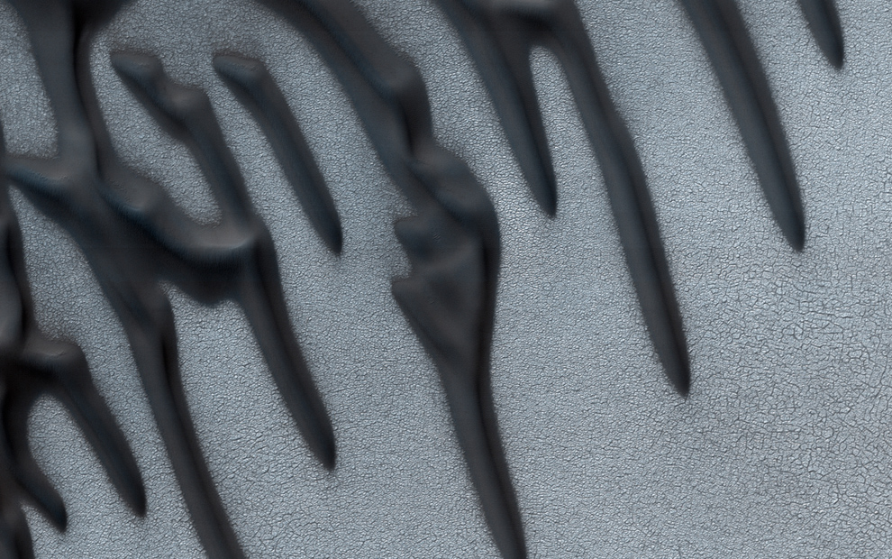
Recurring slope lineae (RSL) are dark narrow streaks on Mars that have puzzled scientists since their discovery in 2011. Image 1 shows a 3-dimensional perspective of a landscape with some of these flow features. RSL form and grow annually and mostly in the warm season, so the mechanism by which they form and grow is tantalizing. To what extent are RSL related to temperature or water? In rugged terrain there are stark temperature contrasts between pole‐facing and equator‐facing slopes that infrared cameras on Mars-orbiting spacecraft cannot spatially resolve. New modeling capabilities make it possible to overcome this limitation and provide surface temperatures at high spatial resolution.

image1_PIA14479

Image 1: An image combining orbital imagery with 3-D modeling shows RSL on a slope inside Newton Crater. Image credit: NASA/JPL-Caltech/University of Arizona.

(more…)

Blocks fragmented in place on the Moon

Post by Dr. O. Ruesch, European Space and Technology Center, European Space Agency (ESA), the Netherlands.

A fragmented block is referred to a cluster of fragments formed by the disruption of a parent block. The identification of such features on planetary surfaces is possible due to the minor spatial dispersion of the fragments away from the parent block. This morphology is to be distinguished from clusters of fragments formed by mass wasting like rockfall or disintegration during block rolldown. Observations of fragmented blocks have been reported on almost every rocky planetary body where images captured by orbital and surface craft resolved features in sufficient spatial detail. Despite the fact that disrupted blocks can reveal important clues on the formation process of soil (regolith) on planetary surfaces, they have started to receive attention only in recent years.

On the airless surface of the Moon, fragmented blocks display a wide range of morphologies (Images 1 and 2). In general, the configurations of the fragments can be described by a continuum from highly catastrophic to sub-catastrophic. Image 1 shows an example of a catastrophic fragmentation where the number and size of the fragments indicate that the parent block was much larger than the largest fragment. The radial pattern formed by small fragments and brighter areas is diagnostic of disruption by a meteoroid impact.

image_1

Image 1. Example of a block fragmented catastrophically near crater Copernicus on the Moon, where the largest fragmented in considerable smaller than the original parent block. LROC/NAC image M127063668LE. http://bit.ly/2mAl0CB

(more…)

Possible Closed-System Pingos in Utopia Planitia, Mars

Post by Dr. Richard Soare, Geography Department, Dawson College, Montreal, QC H3Z 1A4, Canada.

On Earth, hydrostatic or closed-system pingos (CSPs) are perennial ice-cored mounds formed by the freeze-thaw cycling of water when or as thermokarst lakes lose their water by drainage or evaporation. The mounds vary in shape from circular or sub-circular to elongate, are sub-kilometer in their long axes and may reach decameters in height. Some mounds show summit depressions, radial fractures and tiers. As the CSPs degrade, small-scale debris flows or slumps may occur; end-stage degradation often is marked by debris-laden ramparts elevated symmetrically or asymmetrically above the surrounding terrain. The presence of closed-system pingos on Mars might thus inform us about the planets’ past and/or present hydrologic conditions (Image 1).

Fig. 1

Image 1: Candidate closed-system pingos (CSPs) at the mid latitudes of Utopia Planitia, Mars
(HiRISE image ESP 027650_2275). Note the location of the potentially ice-cored mounds in polygonised thermokarst-like depressions and the interesting mound morphologies. On Earth, CSPs form almost uniquely in the midst of drained or water-depleted thermokarst lakes (alases) that are nested in ice-rich terrain. On Mars, we propose that the depressions form by the sublimation-driven loss of near-surface ice; this would also be the principal driver of ice-core depletion and/or collapse. Mounds 1-4 exhibit circular shapes and summit depressions that are commonplace amongst CSPs in regions like the Tuktoyaktuk Coastlands of northern Canada. The crescentic shape of Mound 5 could be a marker of mound collapse and the deflation/sublimation of a near-surface ice core, the geological buttress of pingo topography on Earth.

(more…)

Back to Titan – anticipating the Dragonfly mission

Post by Dr. Stéphane Le Mouélic, Laboratoire de Planétologie et Géodynamique, CNRS UMR6112- University of Nantes, Nantes, France.

Titan is one of the most fascinating bodies of our Solar System. Bigger than Mercury, this satellite of Saturn is veiled by a thick atmosphere of nitrogen containing a few percent of methane. Aerosols formed in the atmosphere by a complex chemistry triggered by the solar UV irradiation produce a global haze totally masking the surface to the naked eye. During 13 years, from July 2004 to September 2017, the Cassini spacecraft orbited Saturn. It took advantage of gravity assist maneuvers to perform 127 equatorial and polar flybys of Titan. Data from the Visual and Infrared Mapping Spectrometer (VIMS) onboard Cassini revealed the distribution of the main compositional units of the surface of Titan (Image 1). The inset in Image 1 shows the 84 km-diameter Selk crater, one of the primary targets chosen for the next New Frontier “Dragonfly” mission, a mobile rotorcraft-lander planned to be launched in 2026.

Image1_SLeMouelic_ann75

Image 1: False color composite of Titan with the red controlled by the 1.59/1.27 µm, green by the 2.03/1.27 µm and blue by the 1.27/1.08 µm band ratios. The equatorial dune fields appear in a consistent brown color. Selk crater is shown in the inset. Credits NASA/JPL/Univ. Arizona/CNRS/LPG.

(more…)

The Moon’s Rolling Stones

Post by Valentin Bickel, PhD student, Department of Earth Sciences, ETH Zurich, CH & Department Planets and Comets, Max Planck Institute for Solar System Research, GER.

One of the most intriguing objects on the surface of the Moon are the “rolling stones”, also known as lunar rockfalls or rolling boulders (Image 1). These boulders are abundant all over the Moon and have sizes that range from a couple of meters to several 10s of meters. Lunar boulders are believed to be displaced by moonquakes or impacts and can carve tracks with lengths that range from a couple of meters to several kilometers (Image 1; Xiao et al., 2013; Kumar et al., 2016). Besides their value for geomorphological analyses, these boulder tracks provide insights into the mechanical behavior and the trafficability of the lunar “soil”, the regolith (Bickel et al., 2019).

IAG_1

Image 1: A number of large and small boulders with tracks at the bottom of a lunar slope. The analysis of tracks provides insights about the mechanical properties of the regolith and is performed using high-resolution satellite imagery, taken by NASA’s Lunar Reconnaissance Orbiter Narrow Angle Camera (NAC).  Detail of NAC Image M113934119LC.

(more…)

Geological Evidence of a Planet‐Wide Groundwater System on Mars

Post by Dr. F. Salese, Marie Curie Postdoctoral Fellow, Faculty of Geoscience, Utrecht University.

Groundwater had a greater role in shaping the Martian surface and may have sheltered primitive life forms as the planet started drying up. Observations in the northern hemisphere show evidence of a planet‐wide groundwater system. The elevations of these water‐related morphologies in all studied basins lie within the same narrow range of depths below Mars datum (Image 1) and notably coincide with the elevation of some ocean shorelines proposed by previous authors. Most previous studies on Mars relevant groundwater have proposed models, but few have looked at the geological evidence of groundwater upwelling in deep closed basins in the northern hemisphere equatorial region. Geological evidence of groundwater upwelling in these deep basins is a key point that will help to validate present-day models and to better constraint them in the future.

Figure 1

Image 1: Morphologies inside several basins. a) Crater #15 shows the presence at the same time of delta, sapping valleys, debris and hummocky terrain. The basin floor is flat. b) Crater #12 shows stepped delta, terraces, shorelines and flow structures at about the same topographic elevations. c) Sapping valley and related stepped delta in crater #18. d) Sapping valley and related stepped delta along with fan and exhumed channels in crater #12. e) Crater #16 shows well-preserved outcrops of debris flow. f) Sapping valley with related delta at -4100m inside crater #22.

(more…)

3D reconstruction on long runout landslides on Mars

Post by Giulia Magnarini, PhD candidate, Department of Earth Sciences, University College London, UK.

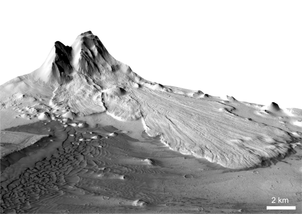
The availability of high resolution imagery of the surface of Mars from NASA’s Mars Reconnaissance Orbiter CTX and HiRISE cameras (NASA PDS) allow us to reconstruct fantastic 3D views of the martian topography using stereophotogrammetry technique. Digital terrain models (DTMs) are obtained using the difference in two images of the same target taken from different angles. In the process, orthoimages are generated and draped over the DTM. CTX stereo-derived DTMs have 20 m/px resolution; HiRISE stereo-derived DTMs have 1-2 m/px resolution. This technique is applied to the study of martian long runout landslides and it represents a powerful tool, as the 3D reconstruction allows detailed observations and morphometric analysis of these landforms and their morphological features (Images 1-3).

Image 1

Image 1: Long runout landslide in Ganges Chasma, Valles Marineris, Mars. CTX stereo-derived DTM at the Mineral and Planetary Sciences division of the Natural History Museum in London. Vertical exaggeration 2x. Image pair: P20_008681_1722_XN_07S044W and P20_009037_1718_XN_08S044W.

(more…)

Degradation of Titan’s impact craters

Post by Joshua E. Hedgepeth, PhD student, Centre for Planetary Science and Exploration, University of Western Ontario, Canada.

Discovered by Huygens in 1656 (Huygens, 1656), the surface of Titan was obscured by its atmosphere for centuries (Campbell, 2003; Smith et al., 1996; Muhleman et al., 1995, 1990; Kuiper, 1944). In 2004, we finally obtained high resolution images of the surface with Cassini RADAR. Cassini was equipped with a Ku-band (2.17 cm λ) radar instrument with 5 beams for collecting data (Elachi et al., 2004; Stofan et al., 2012). The long wavelength band was able to penetrate Titan’s thick haze to perform radiometry, scatterometry, altimetry and synthetic aperture radar (SAR) imaging of the surface. The SAR mode captured the highest resolution images of the surface of Titan, as high as 175 meters per pixel (Elachi et al., 2004; Lopes et al., 2010). While this may not be as high resolution as the images we have of other moons, it is high enough to obtain some spectacular images. In this blog we have a detailed look at the craters on the surface of Titan.

selk

Image 1: Selk crater (D=84 km) located at 199.1, 6.9 latitude and longitude. The dark crater floor is representative of the smooth material, and around it is the bright rough ejecta material.

(more…)

Evidence against vast glaciation in Mars’ grandest canyons

Post by Miss. L. Kissick, PhD candidate, Department of Earth Sciences, University of Oxford. Research conducted while at the Department of Geography, Durham University.

The Valles Marineris (Image 1) form the largest system of interconnected canyons on Mars, up to 2000 km long and in parts 10 km deep, and have long been a focal point of interest in planetary geomorphology. Recently, researchers including Mège and Bourgeois (2011), Cull et al. (2014), and Gourronc et al. (2014) outlined the case for a vast glaciation filling these canyons to several kilometres in depth. The implications of such a fill on the climate history and global water budget of Mars would be paradigm-shifting, but with high resolution imagery, features attributed as glacial may be better explained by more common geomorphological processes.

IM1

Image 1: Valles Marineris in Mars Orbital Laser Altimeter topography. This enormous canyon system is in parts 10 km deeper than the surrounding plateau, and was hypothesised to contain a glacier of a volume comparable to each Martian polar cap (Gourronc et al., 2014). Rough areas described in Image 2 are circled. Image adapted from Figure 1 of Kissick and Carbonneau (2019).

(more…)

The banded terrain on Mars – A viscous cufeve

Posted by Dr. Hannes Bernhardt, Arizona State University, School of Earth and Space Exploration.

An article on the banded terrain cannot be commenced by a traditional definition, as it appears to be a truly singular occurrence in the Solar System. In a competition for the most mysterious landscapes on Mars, the so called “banded terrain” (Image 1) would certainly be a hot contender – a fact illustrated by one of its other descriptive appellations: “Taffy pull terrain.” It is a strong reminder of the limitations that are intrinsic to remote sensing geology but also of the strengths of comparative geomorphology.

PlanGeomorph_Figure1

Image 1: CTX images of the banded terrain on the Hellas basin floor on Mars.

(more…)

Haulani crater on the dwarf planet Ceres

Posted by Dr. Katrin Krohn, German Aerospace Center, Institute of Planetary Research

Haulani is one of the most prominent features on Ceres. The impact crater has bright interior and extensive ejecta with farranging crater rays of about 160 km to 490 km. Haulani shows an overall smooth bright crater floor with flow features and some cracks in the floor’s northwestern part, parallel to the impact crater rim. This crater exhibits a hummocky elongated mountainous ridge in the central part of the crater with flows running downslope the ridge crest ponding toward mass-wasting deposits of the rim. Pits occur on the crater floor and in parts of Haulani’s ejecta. Since Ceres shows evidence of a volatile-rich crust, the pits are likely due to rapid post-impact outgassing of hydrated salts or ground ice.

figure1_haulani_color

Image 1: Color mosaic of Haulani, showing the diverse morphology of the crater.

(more…)

Phobos Grooves from Rolling Boulders

Post by Kenneth R. Ramsley, Department of Earth, Environmental and Planetary Sciences, Brown University.

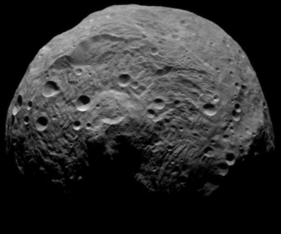
All but one region of Phobos, the largest moon of Mars, is covered by hundreds of valley-like features, usually described as grooves. Most grooves are ~80 to ~200 meters wide and are found in groups of generally parallel members, or families [see Image 1]. Impact craters typically produce slow-moving boulders, and on Phobos there would be little gravity to halt their motions. Did boulders rolling across the surface of Phobos produce the grooves? To answer this question, using a computer model to calculate the fate of rolling boulders, we compare their motions to the geomorphology of the grooves.

Image 1 - Viking Image

Image 1: Dominated by Stickney Crater, a feature nearly half the radius of the moon itself, Phobos is the larger of the two moons of Mars (average diameter, 22 kilometers). Mostly covered in valley-like features, planetary scientists have struggled for more than 40 years to explain the grooves of Phobos (Viking Project, JPL, NASA; Image mosaic by Edwin V. Bell II NSSDC/Raytheon ITSS).

(more…)

Reconstructing glaciers on Mars

Post by Dr. Stephen Brough, School of Geography, Politics and Sociology, Newcastle University, UK.

There exist thousands of putative debris-covered glaciers in the mid-latitudes of Mars (e.g. Souness et al., 2012; Levy et al., 2014). Much like their terrestrial counterparts, many of these glaciers have undergone mass loss and recession since a former glacial maximum stand (e.g. Kargel et al., 1995; Dickson et al, 2008) (Image 1). However, there is a lack of knowledge regarding the volume of ice lost since that time and whether such recession has been spatially variable. Reconstructing glacial environments based on their landforms and structural assemblage is a powerful concept applied in terrestrial glaciology. Through utilising evidence left on the landscape with observations from modern glaciers, it is possible to reconstruct the extent and dynamics of both former (glaciated) and modern (glacierised) glacial environments (see Bennett and Glasser, 2009). This month’s planetary geomorphology post investigates how similar techniques have been utilised to reconstruct the former extent of glaciers on our planetary neighbour, Mars.

Image_1

Image 1: Glacier recession on Earth and Mars. (a – b) Location of martian glacier in the Phlegra Montes region of Mars’ northern hemisphere (~164.48 oE, ~34.13 oN). Background is MOLA elevation overlain on THEMIS-IR daytime image. (c) Near terminus Context Camera (CTX) image expansion of Phlegra Montes martian glacier. White arrows indicate arcuate ridges in glacier forefield that occupies the southern half of image. Subset of CTX image P16_007368_2152_XN_35N195W. (d) The forefield of terrestrial Midre Lovénbreen, Svalbard, is shown for comparison. White arrows indicate arcuate terminal moraine indicating the glacier’s former expanded extent. Modified from Hubbard et al., 2014.

(more…)

Sandstone outcrops seen with the ExoMars PanCam emulator

Post by Dr. Peter Fawdon, (@DrPfawdon) School of Physical Sciences, The Open University, United Kingdom

PanCam (Coates et al., 2017) is the imaging instrument on the 2020 ExoMars rover and consists of two wide angle cameras; (WAC’s) and a High Resolution Camera (HRC). PanCam will be used to lead the geological characterisation of the local area outcrops. It will be used to establishing the geological setting of outcrops and identify targets for subsurface sampling and analysis with the ExoMars drill and suite of analytical instruments (Vago et al., 2017).

An emulator for the ExoMars PanCam instrument has been used in rover operation field trials in southern Spain. The aim of these trials has been to explore how scientists will use the instruments in rover missions. These images, taken by the emulator, are examples of what PanCam data might look like and show how the PanCam images will be used (e.g., Harris et al., 2015).

Picture1

Image 1: PanCam Multi-spectral images: (A) A colour composite made from the red, green and blue filters shows a ridge named ‘Glengoyne’ at approximately 20 m distance from the rover. (B) A Multi spectral image using the geology filters stretched to emphasise the variation in the scene.

(more…)

Universality of delta bifurcations

Post by Dr. Robert C. Mahon, Department of Earth and Environmental Science, University of New Orleans

Which morphologic features of sedimentary systems persist into the stratigraphic record? Ancient river deltas preserved as stratigraphic deposits on both Earth and Mars exhibit remarkable morphologic similarities to modern deltas on Earth (Images 1-3). While channel dynamics may be expected to alter the geomorphic expressions of past channel networks, in many cases channel bodies appear to be preserved in their original configurations. Fully understanding the ways in which geomorphic features become preserved as stratigraphy can provide tools for us to both infer past processes from the ancient deposits with greater confidence, as well as to predict the geometries of ancient deposits in the subsurface (i.e. for resource exploration).

Aeolis

Image 1: CTX image mosaic of a delta in the Aeolis region of Mars, showing distributary channel networks. CTX imagery courtesy of NASA-MRO/JPL/UA.

(more…)

The Largest Delta on Mars?

Post by Jacob Adler, School of Earth and Space Exploration, Arizona State University.

Ancient river deltas are found in many locations on Mars [see Di Achile & Hynek, 2010 and references therein], and are formed as sediment drops out of suspension in water as it approaches a wider shoreline of a lake, sea, or (debatably) an ocean. Some proposed deltas on Mars are found in closed basins (e.g. an impact crater) away from the Martian dichotomy boundary, implying an ancient climate during which the crater ponded with water [e.g. Eberswalde or Jezero]. Occasionally, inlet and outlet river valleys are seen at different elevations along the crater rim, lending further evidence to the hypothesis that the crater filled with liquid water at least up to the outlet elevation. Deltas found in open basins, on the other hand, imply a larger body of standing water, and Mars scientists look for other clues to support the deltaic rather than alluvial fan formation mechanism. In our recent papers, we tested whether the Hypanis fan-shaped deposit (Image 1) could be a delta, and discussed whether this supports the hypothesis that there was once a large sea or ocean in the Northern plains of Mars [Adler et al., 2018; Fawdon et al., 2018].

Image1

Image 1: a) The Hypanis deposit stands out as light-toned in the center of this Mars Reconnaissance Orbiter (MRO) Context Camera (CTX) mosaic of our study region. Also marked are Lederberg crater, and the Sabrina deposit in the closed basin of Magong crater. (b) Hypanis and Sabrina have a low nighttime temperature (dark) as recorded by the THEMIS instrument on Mars Odyssey, suggesting it is mostly composed of small grain size material. Image from the Nighttime IR 100m Global Mosaic v14.0 [Hill et al. (2014); Edwards (2011)] and from the Northern Hypanis Valles Night IR Mosaic [Fergason (2009)]. NASA/JPL/ASU. (c) Our proposed fluvial sequence discussed in the paper. Main lobe (A) could once have had continuous layered beds spanning to the distal island deposits (E). The cross-cutting relationships we observed are consistent with hypothesized shoreline regression to the north. Flow migrated to the northern lobe (B), then to braided inverted channels (C and D) as water retreated. NASA/MSSS/USGS. d) Our digital elevation mosaic shows the topography of Hypanis and surrounding features. Elevations are colored from white (-2500 m) to light green (-2800 m).

(more…)

Measuring Cross-Bed Geometry in Upper Aeolis Mons, Gale Crater, Mars

Post by Dr. Ryan B. Anderson, Astrogeology Science Center, United States Geological Survey

One of the most environmentally diagnostic features of sedimentary rocks is cross-bedding, which occurs when sediment is transported by wind, water, or volcanic processes, resulting in horizontal strata composed of inclined beds. The geometry of cross-bedded sedimentary deposits provides information about the depositional setting and post-depositional history of the rocks, making the identification, measurement, and interpretation of cross-beds particularly interesting on Mars, where past conditions are of great scientific interest. This post describes cross-bedding in Upper Aeolis Mons in Gale crater (Image 1).

gale_xbeds_fig1

Image 1: Example of complex bedding patterns in upper Aeolis Mons, interpreted to be large-scale aeolian cross beds. Image is an inset of HiRISE observation PSP_001620_1750.

(more…)

Enigmatic Normal Faults on Ceres

Post by Kynan Hughson, Department of Earth, Planetary, and Space Sciences, University of California, Los Angeles, USA.

Since March of 2015 NASA’s Dawn spacecraft has been actively exploring the main asteroid belt’s largest member and only dwarf planet in the inner solar system: Ceres. Situated around two fifths of the way between the orbits of Mars and Jupiter, Ceres is gargantuan compared to its neighbors. With a mean diameter of ~946 km (approximately the width of the state of Texas) and a bulk density of ~2.16 g/cm3 it comprises around one third of the mass of the entire main belt. Dawn’s continuing examination of this unique object since March 2015 has revealed a geologically diverse world covered with geomorphological features common to both rocky inner solar system planets and icy outer solar system satellites (e.g. Bland et al., 2016; Schmidt et al., 2017; Fu et al., 2017). These observations have exacerbated Ceres’ refusal to be neatly categorized as either a rocky or icy planet.

narSulcusRotation

Image 1: A rotating aerial view of Nar Sulcus (centered at approximately 79.9 °W, 41.9 °S). Note the two nearly perpendicular sets of fractures. In particular, note the imbricated blocks within the longer fracture set. The longer fracture set is approximately 45 km long, and the deepest valleys are ~400 m deep. This scene was created using a stereophotogrammetrically (SPG) derived elevation model (vertical resolution ~15 m) and high resolution (~35 m/pixel) Dawn framing camera mosaics (Roatsch et al., 2016a; Roatsch et al., 2016b), which are available on the Small Bodies Node of NASA’s Planetary Data System.

(more…)

What is happening in Titan’s equatorial belt?

Post by Jeremy BrossierDeutsches Zentrum für Luft- und Raumfahrt (DLR), Institute of Planetary Research, Berlin, Germany.

During the last thirteen years (2004 – 2017), the Cassini-Huygens mission allowed a real revolution in the exploration of Titan, the largest moon of Saturn. This mission has revealed that Titan is – in many aspects – very similar to Earth. Titan is a frozen version of Earth, where methane behaves as water, and water ice may be as hard as rock. Despite its strange characteristics, Titan undergoes a rich variety of surface processes that are likewise analogous to those on our planet. Titan being entirely shrouded by a dense atmosphere made of dinitrogen, methane and solid organic particles (i.e. tholins), direct observation of its surface is only possible through radar data, as well as infrared data within specific wavelengths intervals. SAR images from the radar, allowed identifying various landscapes on the moon (see Image 1), and evaluating their global distribution, notably for the lakes and dunes. Lakes are mostly confined around the poles, while the dunes dominate the equatorial belt. Thus, the shape of Titan’s surface seems quite well understood thank to SAR images, however, it is crucial to determine not only the morphology, but also the nature of the material composing or coating the various landscapes to better understand the geology of this intriguing moon.

Image1

Image 1: A few examples of Titan’s landscapes seen through SAR images, including (A) mountain chains embayed by plains, (B) undifferentiated plains, (C) impact crater, (D) dunes, (E) river channels, (F) small lakes, and (G) a close up of the second largest sea, namely Ligeia Mare. SAR images were acquired during Titan flybys (A, B) T43 in May 2008, (C) T77 in June 2011, (D) T21 in Dec. 2006, (E) T44 in May 2008, (F) T19 in Oct. 2006, and finally (G) T28 in April 2007. Note that Titan flybys are tagged with the abbreviated target name “T” and the flyby number.

(more…)

Morphological Evidence that Titan’s Southern Hemisphere Basins are Paleoseas

Post by Samuel Birch, Cornell University, Ithaca, USA.

Titan is the only body in the solar system, besides the Earth, known to currently have standing bodies of liquids on its surface [Stofan et al., 2007]. Presently, liquids are restricted to the polar regions (>50o) with liquid bodies in the North encompassing 35 times more area as compared to the South [Hayes et al., 2011; Birch et al., 2017a]. Apsidal precession of Titan’s obliquity over ~100,000 year cycles, analogous to the Earth’s Croll-Milankovitch cycles, likely forces liquids from pole-to-pole, and has been invoked as a physically plausible mechanism to account for the dichotomy [Aharonson et al., 2009]. General circulation models support such a mechanism, as Titan’s current orbital configuration produces more intense, high-latitude, baroclinic eddies over the southern hemisphere, preferentially depositing more liquid at the northern pole [Lora & Mitchell, 2015]. These models, therefore, imply that the presence of northern liquids is transient over geologic timescales. Large basins able to accommodate ~70,000 km3 of liquid methane and ethane [Hayes, 2016] are required when orbital and climatic conditions become favorable for the accumulation of southern seas. Our study [Birch et al. 2017b] identifies four large basins, all of which show morphological evidence for having been formerly filled by liquids.

SB_Image1

Image 1: Polar stereographic projection of SAR image data of the South polar region extending out to 60o latitude. SAR image data includes all flybys up to and including T98. A mosaic of ISS data underlays the SAR mosaic. The perimeters of the four basins that we identified are highlighted in yellow.

(more…)

Stepped Fans and Phyllosilicates on Mars

Post by Peter Grindrod, Natural History Museum, London, UK.

A number of different studies have catalogued features on Mars that could be given the general heading of sedimentary fans [e.g. Irwin et al., 2005; Kraal et al. 2008]. These features occur whenever the velocity of a river or stream decreases, and the water no longer has enough energy to carry its sediment, and thus begins to deposit its load. This drop in energy often occurs when the water flows into flatter and wider regions. The distribution of these fans on Mars is important because it shows the location of past water flows, and the amount of material that has been transported (which can be used as a proxy for flow duration).

However, one of the fundamental problems when looking at these features with orbital data alone, is that it is difficult to determine whether the river flowed into a standing body of water (for example a lake) or just an empty canyon or crater. Of course, the implications of this problem are important if we want to understand the volume and distribution of past water on Mars, which in themselves feed into understanding the past climate and even habitability of Mars.

Figure 1

Image 1: Location of the two fans in Coprates Catena, SE Valles Marineris. MOLA elevation overlain on THEMIS daytime image.

(more…)

Geologically recent glacial melting on Mars

Post by Frances. E. G. Butcher, School of Physical Sciences, Open University, UK.

Thousands of putative debris-covered glaciers in Mars’ middle latitudes host water ice in volumes comparable to that of all glaciers and ice caps on Earth, excluding the Greenland and Antarctic ice sheets (Levy et al., 2014). These glaciers formed within the last 100 million to 1 billion years of Mars’ geological history (Berman et al., 2015), a period that is thought to have been similarly cold and hyper-arid to present-day Mars. This is broadly corroborated by a sparsity of evidence for melting of these geologically ‘young’ mid-latitude glaciers, which suggests that they have always been entirely frozen to their beds in ‘cold-based’ thermal regimes, and haven’t generated meltwater (e.g. Marchant and Head, 2007). Nevertheless, this months’ planetary geomorphology image provides evidence for melting of one such glacier.

Image1

Image 1: An esker emerging from the tongue of a debris-covered glacier in Tempe Terra, Mars. See Image 2 for an annotated 3D view of this scene. The dashed white line delineates the terminus of the debris-covered glacier, which occupies the southern and eastern portions of the image. The white arrow marked A indicates the first emergence of the crest of the esker ridge from the glacier surface. The white arrow marked A’ indicates the northernmost end of the esker ridge in the deglaciated zone beyond the ice terminus. Context Camera image P05_002907_2258_XN_45N083W (Malin et al., 2007). Modified from Butcher et al., 2017 under a Creative Commons license CC BY 4.0.

(more…)

Enigmatic Clastic Polygons on Mars

Post by Laura Brooker, Open University, Milton Keynes, UK.

Polygonal ground of centimetre- to decametre-scale is one of the most common features found in cold-climate regions on Earth and on Mars. Polygonal shapes on Earth can form through a number of different processes including the thermal contraction of ice-cemented soils, forming fracture patterns known as thermal contraction polygons, through the freezing and thawing of ground ice moving clasts, in the case of sorted patterned ground, or through the dehydration of volatile-rich material, termed desiccation polygons. Around a large crater found in the northern latitudes of Mars, named Lyot, we observe stunning and unusually large clastic polygons (Image 1), but how do they form? To understand landforms on Mars we turn to analogues on Earth and compare morphological data to look for similarities and differences.

Image 1

Image 1: HiRISE (ESP_016985_2315) image of clastic polygonal ground observed to the north east of Lyot crater, Mars. These enigmatic polygons are demarcated by clastic material in their borders and are averagely 130 metres in diameter. Image credit: NASA/JPL/University of Arizona.

(more…)

  • Enter your email address to follow this blog and receive notifications of new posts by email.

  • Io

  • Blog Stats

    • 192,924 hits