Surface expressions of ice flow on Earth and Mars

Post contributed by Dr Anna Grau Galofre, Laboratoire de Planetologie et Geosciences, CNRS UMR 6112, Nantes Universite, Universite d’Angers, Le Mans Universite, France.

Glaciers, ice sheets, and ice masses in general, are both agents of landscape evolution and a part of the landscape itself, when considered at human time scales, with surfaces that evolve and record changes in environmental conditions. The ages of glaciers and ice sheets on Earth, which range from thousands to millions of years, dwarf in comparison with the ages of debris-covered ice masses on Mars. Debris-covered martian ice deposits range up to hundreds of millions of years old, perhaps approaching 1 billion years old in some locations. Image 1 shows complex patterns on the surface of a debris-covered glacier on Mars. Terrestrial glacial surface deformation patterns can record changes in environmental conditions, which are also captured in the variability in chemistry and crystal structure seen in their internal stratigraphy. The morphology of a glacier surface, for example, may reflect episodes of warmer climate, and therefore enhanced ice flow; banding patterns may reflect periodic changes in the mass balance of ice accumulation and ice loss; and crevasses may reflect episodes when ice flowed relatively fast and fractured. The surface morphology of glaciers and debris-covered ice deposits can thus help us learn about the history of climate on Earth and Mars.
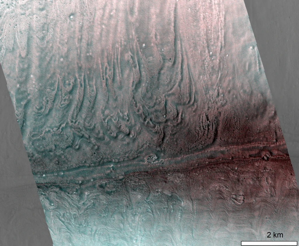
Image 1. Surface banding patterns on a debris-covered, cold based ice deposit (called a ‘lobate debris apron’) flowing down a canyon wall in Reull Vallis, Mars. Extract from CaSSIS image MY34_005511_224 (footprint width is 9 km). Image credit: ESA/CaSSIS.

(more…)
Superposed glaciers on Mars: what, where, when, and why?

Post contributed by Adam J. Hepburn, Department of Geography and Earth Sciences, Aberystwyth University, UK.

Mars hosts abundant glacier-like landforms throughout its mid-latitudes, the presence of which necessitates major shifts in climate relative to present conditions. These ice-rich viscous flow features (VFFs) are typically found in coalescing, size-hierarchical systems whereby lower-order glacier-like forms (GLFs; ~5 km long) flow from alcoves and merge with higher-order lineated valley fill (LVF; 100s of km long). Several larger VFFs have been dated previously, indicating Mars underwent glaciation in the past several hundred million years, during the late Amazonian epoch.  However, several authors have noted examples of GLFs flowing onto, rather than into, LVFs (Image 1), and hypothesised that these may correspond to a more recent phase of glacial activity. We used crater dating to ascertain that—in addition to the earlier phase of widespread regional glaciation—these superposed GLFs (SGLFs) were formed following at least two major cycles of more recent alpine glaciation, the latter of which ended ~2 million years ago.

Image 1: Superposed glacier-like form (SGLF) flowing onto the underlying viscous flow feature (underlying VFF), in the Protonilus Mensae region of Mars. (A–B) North-up orientated HiRISE image (ESP_018857_2225) image of an SGLF (light blue) emerging from an alcove and flowing onto lineated valley fill (dark blue). Approximate location of image centre is 42.23◦ N, 50.53◦ E. Reproduced from Hepburn et al, 2020.

(more…)

Evidence against vast glaciation in Mars’ grandest canyons

Post by Miss. L. Kissick, PhD candidate, Department of Earth Sciences, University of Oxford. Research conducted while at the Department of Geography, Durham University.

The Valles Marineris (Image 1) form the largest system of interconnected canyons on Mars, up to 2000 km long and in parts 10 km deep, and have long been a focal point of interest in planetary geomorphology. Recently, researchers including Mège and Bourgeois (2011), Cull et al. (2014), and Gourronc et al. (2014) outlined the case for a vast glaciation filling these canyons to several kilometres in depth. The implications of such a fill on the climate history and global water budget of Mars would be paradigm-shifting, but with high resolution imagery, features attributed as glacial may be better explained by more common geomorphological processes.

IM1

Image 1: Valles Marineris in Mars Orbital Laser Altimeter topography. This enormous canyon system is in parts 10 km deeper than the surrounding plateau, and was hypothesised to contain a glacier of a volume comparable to each Martian polar cap (Gourronc et al., 2014). Rough areas described in Image 2 are circled. Image adapted from Figure 1 of Kissick and Carbonneau (2019).

(more…)

The banded terrain on Mars – A viscous cufeve

Posted by Dr. Hannes Bernhardt, Arizona State University, School of Earth and Space Exploration.

An article on the banded terrain cannot be commenced by a traditional definition, as it appears to be a truly singular occurrence in the Solar System. In a competition for the most mysterious landscapes on Mars, the so called “banded terrain” (Image 1) would certainly be a hot contender – a fact illustrated by one of its other descriptive appellations: “Taffy pull terrain.” It is a strong reminder of the limitations that are intrinsic to remote sensing geology but also of the strengths of comparative geomorphology.

PlanGeomorph_Figure1

Image 1: CTX images of the banded terrain on the Hellas basin floor on Mars.

(more…)

Reconstructing glaciers on Mars

Post by Dr. Stephen Brough, School of Geography, Politics and Sociology, Newcastle University, UK.

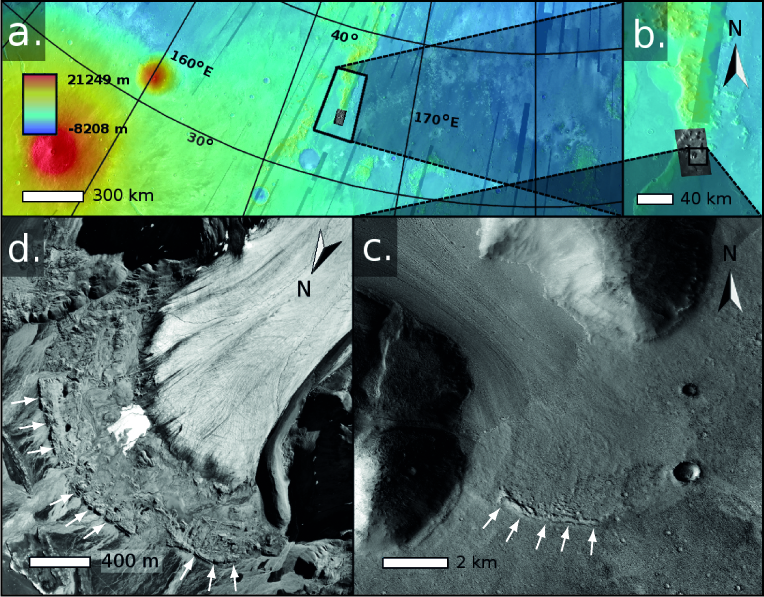
There exist thousands of putative debris-covered glaciers in the mid-latitudes of Mars (e.g. Souness et al., 2012; Levy et al., 2014). Much like their terrestrial counterparts, many of these glaciers have undergone mass loss and recession since a former glacial maximum stand (e.g. Kargel et al., 1995; Dickson et al, 2008) (Image 1). However, there is a lack of knowledge regarding the volume of ice lost since that time and whether such recession has been spatially variable. Reconstructing glacial environments based on their landforms and structural assemblage is a powerful concept applied in terrestrial glaciology. Through utilising evidence left on the landscape with observations from modern glaciers, it is possible to reconstruct the extent and dynamics of both former (glaciated) and modern (glacierised) glacial environments (see Bennett and Glasser, 2009). This month’s planetary geomorphology post investigates how similar techniques have been utilised to reconstruct the former extent of glaciers on our planetary neighbour, Mars.

Image_1

Image 1: Glacier recession on Earth and Mars. (a – b) Location of martian glacier in the Phlegra Montes region of Mars’ northern hemisphere (~164.48 oE, ~34.13 oN). Background is MOLA elevation overlain on THEMIS-IR daytime image. (c) Near terminus Context Camera (CTX) image expansion of Phlegra Montes martian glacier. White arrows indicate arcuate ridges in glacier forefield that occupies the southern half of image. Subset of CTX image P16_007368_2152_XN_35N195W. (d) The forefield of terrestrial Midre Lovénbreen, Svalbard, is shown for comparison. White arrows indicate arcuate terminal moraine indicating the glacier’s former expanded extent. Modified from Hubbard et al., 2014.

(more…)

Geologically recent glacial melting on Mars

Post by Frances. E. G. Butcher, School of Physical Sciences, Open University, UK.

Thousands of putative debris-covered glaciers in Mars’ middle latitudes host water ice in volumes comparable to that of all glaciers and ice caps on Earth, excluding the Greenland and Antarctic ice sheets (Levy et al., 2014). These glaciers formed within the last 100 million to 1 billion years of Mars’ geological history (Berman et al., 2015), a period that is thought to have been similarly cold and hyper-arid to present-day Mars. This is broadly corroborated by a sparsity of evidence for melting of these geologically ‘young’ mid-latitude glaciers, which suggests that they have always been entirely frozen to their beds in ‘cold-based’ thermal regimes, and haven’t generated meltwater (e.g. Marchant and Head, 2007). Nevertheless, this months’ planetary geomorphology image provides evidence for melting of one such glacier.

Image1

Image 1: An esker emerging from the tongue of a debris-covered glacier in Tempe Terra, Mars. See Image 2 for an annotated 3D view of this scene. The dashed white line delineates the terminus of the debris-covered glacier, which occupies the southern and eastern portions of the image. The white arrow marked A indicates the first emergence of the crest of the esker ridge from the glacier surface. The white arrow marked A’ indicates the northernmost end of the esker ridge in the deglaciated zone beyond the ice terminus. Context Camera image P05_002907_2258_XN_45N083W (Malin et al., 2007). Modified from Butcher et al., 2017 under a Creative Commons license CC BY 4.0.

(more…)

  • Enter your email address to follow this blog and receive notifications of new posts by email.

  • Io

  • Blog Stats

    • 192,914 hits