The effect of gravity on river deltas

Post contributed by Dr Lisanne Braat, European Space Agency (ESA)

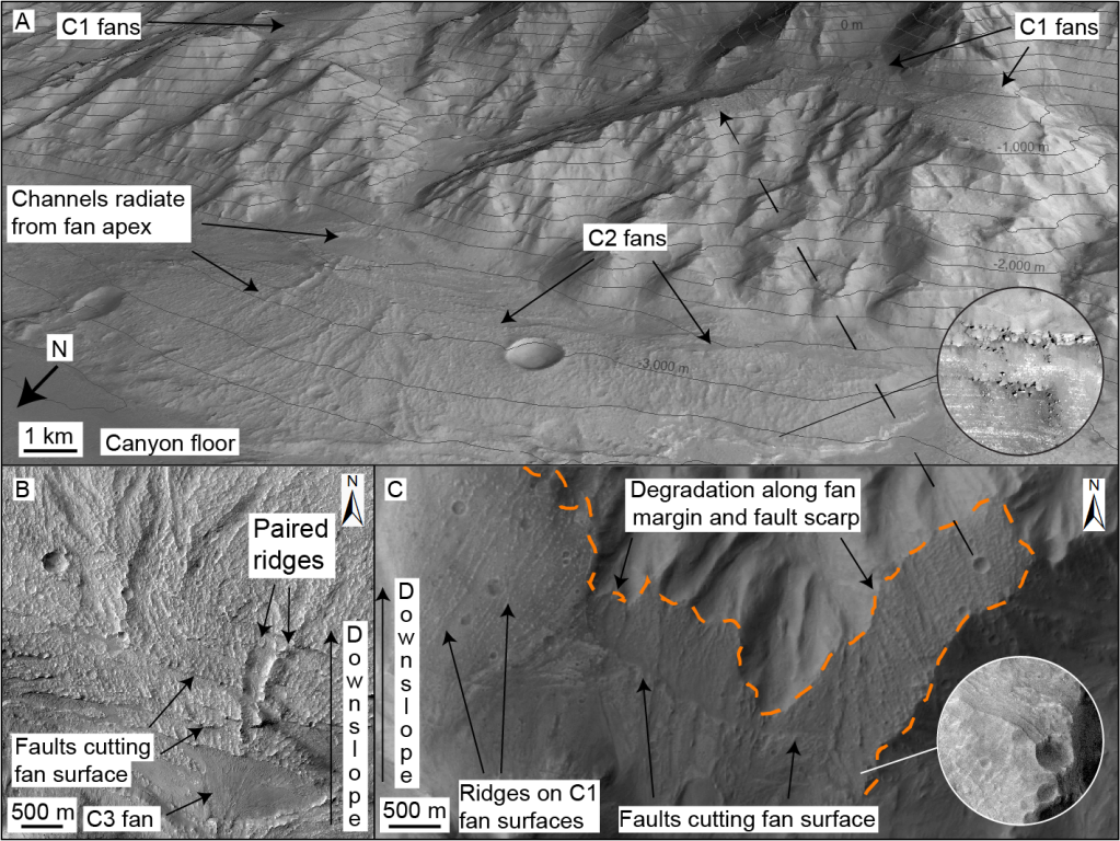
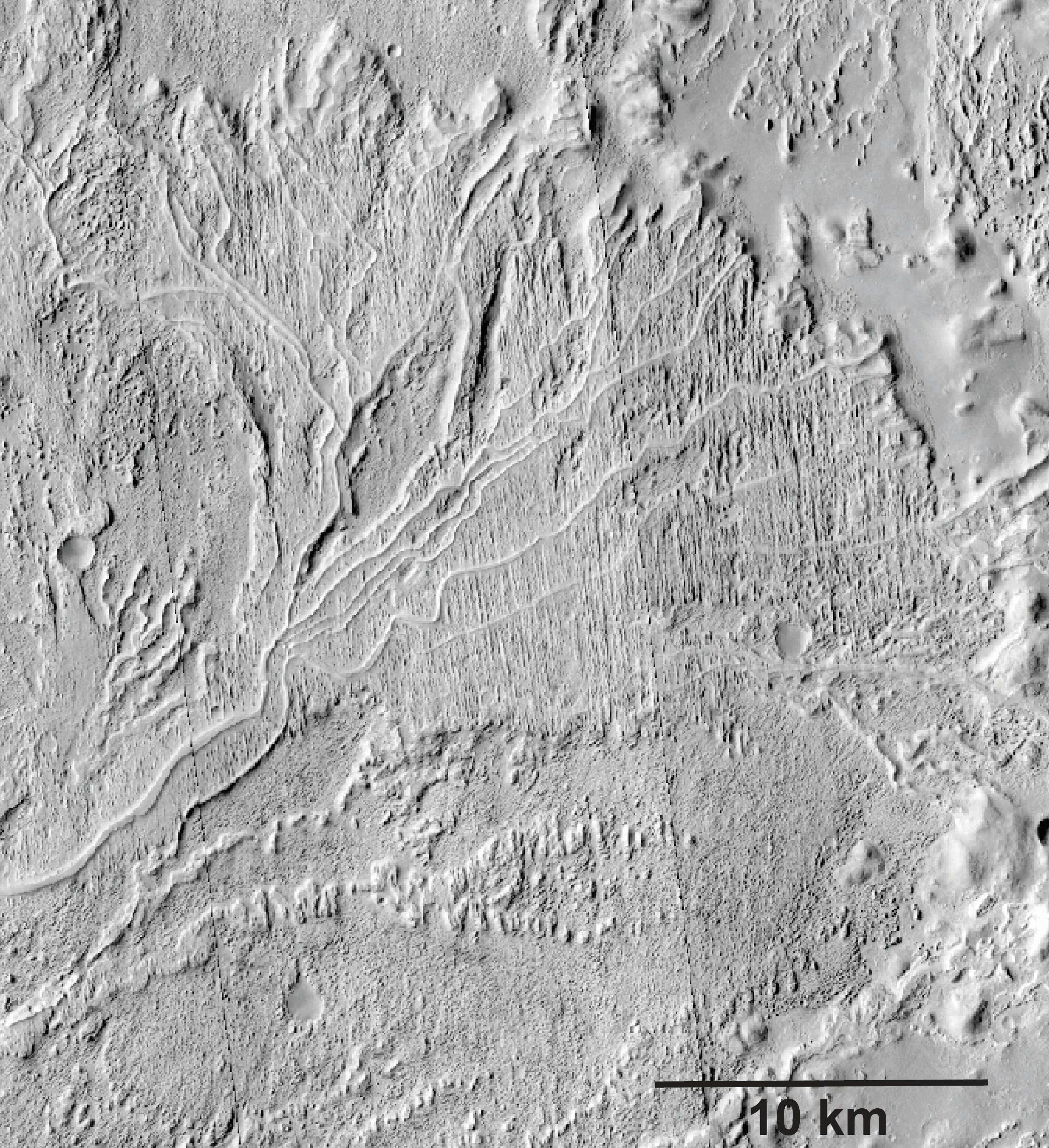
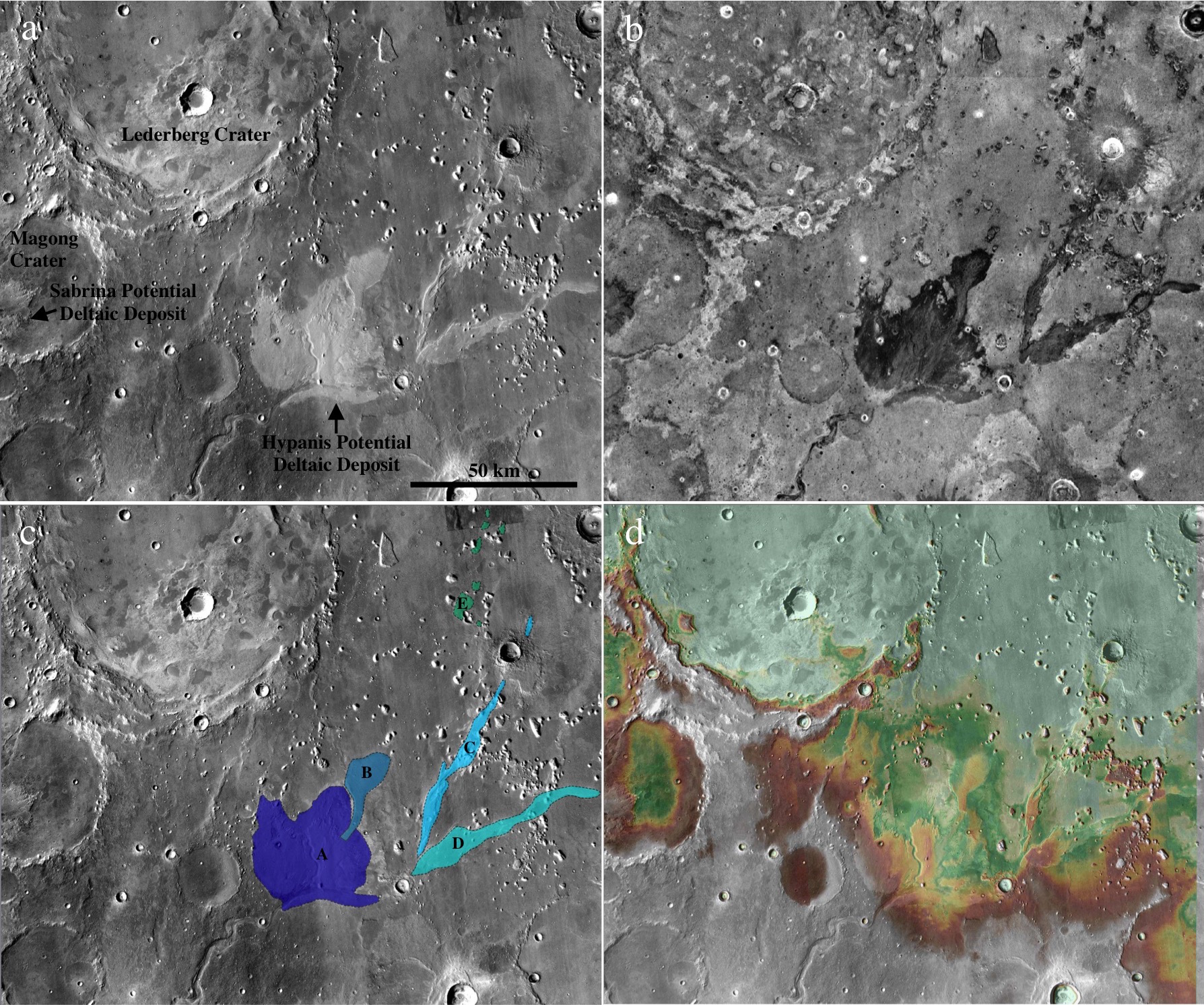
Deltas form when a river flows into a standing body of water. When the flow decelerates the sediment carried by the river settles and forms the delta. On Earth we have numerous active deltas where rivers meet lakes, seas, and oceans. Examples of Earth’s deltas can be seen on the left side of Image 1. On Mars, we observe many remnants of ancient deltas that are no longer active (shown on the right side of Image 1), such as the delta in Jezero Crater where the Perseverance rover currently explores. Preserved sediment deposits in these Martian deltas provide valuable insights into past processes on the planet’s surface and the presence of water. To better understand these landforms on Mars, we rely on knowledge gained from active delta systems on Earth. However, is it fair to do so when the gravity on Mars is much lower? How does gravity affect sediment transport and delta morphology?

Image 1: Animated GIF comparing Deltas on Earth and Mars. Left, examples of active deltas on Earth (source: Landsat). Right, examples of preserved ancient deltas on Mars (source: JMARS composite of CTX Global Mosaic, Murray Lab, and HRSC MOLA Blended DEM 200m v2).

(more…)

Enigmatic flows in Chryse Planitia on Mars – mud or lava?

Post contributed by Dr. Petr Brož, Institute of Geophysics of the Czech Academy of Sciences.

Kilometer-sized flows (KSFs) have been observed in many regions on Mars and have typically been interpreted as lava flows. However, sedimentary volcanism has been proposed as an alternative origin for some martian KSFs. Remarkable examples of such hypothesized sedimentary KSFs are located at the southern margin of Chryse Planitia, a large impact basin that has been partly infilled by sedimentary strata. There, dozens of such flows (Images 1 and 2) are associated with >1000 conical and dome-shaped edifices that have been previously interpreted to result from subsurface sediment mobilization (Komatsu et al., 2016, Brož et al., 2019); however their formation mechanism still remains enigmatic due to the absence of ground truth. To get deeper insight about the formation of these KSFs we generated seven Digital Elevation Models computed from HiRISE stereo pair images enabling us to reveal their detailed, meter-scale morphology (Image 2). As a result, we have been able confirm that KSFs are indeed aggradational edifices formed by the movement of a low viscosity liquid (Image 2b). Several of the observed morphologies associated with these flows suggest that such liquid had to be a mixture of water and sediment, i.e., mud, rather than silicic lava. In such a case, the southern part of Chryse Planitia is a region on Mars where subsurface sediment mobilization could have operated in the past and hence represents a promising site for future exploration where deeper-sourced sedimentary deposits are exposed at the surface.

Image 1: An example of kilometer-sized flow in Chryse Planitia consisting of three main parts as captured in CTX image P17_007639_1997_XN_19N034W, centered 19.85°N, 326.02°E).

(more…)

Syn-tectonic Sedimentation in Valles Marineris, Mars

Post contributed by Dr Joel Davis, Department of Earth Sciences, Natural History Museum, UK

On Earth, the interplay between tectonics and sedimentation is commonplace. In regions such as Death Valley, USA, extensional tectonic processes have formed sedimentary basins, where the subsequent erosion of the landscape causes the formation of features such as alluvial fans. Alluvial fans are conical-shaped, sedimentary deposits usually formed by stream flows in upland regions. Later tectonic activity can lead to the deformation and relative uplift of these landforms. A new generation of alluvial fans may then form, overprinting the older generation and extending down to the new position of the basin floor.

To contrast, as most alluvial fans on Mars are found within impact craters, they do not show evidence of tectonic deformation. The alluvial fans hosted within the canyons of Valles Marineris appear to be an exception to this (Figure 1). Valles Marineris may have developed over billions of years by repeated episodes of normal faulting. In several regions of Valles Marineris, not only are alluvial fans found on the current floor, but remnants of such features are found on the canyon walls as well – perched several kilometres above the floor!

Figure 1: Faulted alluvial fan deposits in Coprates Chasma, Mars. (A) Oblique Context Camera (CTX) image of multiple generations of alluvial fan deposits, offset by faulting. Credit: NASA/JPL/MSSS. Inset shows High Resolution Imaging Science Experiment (HiRISE) image of bright-toned layering in fan margins. Topographic contour interval is 200 m. Credit: NASA/JPL/UoA. (B) HiRISE mosaic of C2 alluvial fan deposits on canyon floor, where surfaces contain distributary channels and paired ridges, cut by multiple faults. Youngest C3 fans superpose faults and are local to C2 fan apices. Credit: NASA/JPL/UoA. (C) Planform CTX mosaic of oldest (C1) alluvial fan deposits (perched terraces), which have been faulted and later eroded (orange line). NASA/JPL/MSSS. After Davis et al., 2021.

(more…)

Sandstone outcrops seen with the ExoMars PanCam emulator

Post by Dr. Peter Fawdon, (@DrPfawdon) School of Physical Sciences, The Open University, United Kingdom

PanCam (Coates et al., 2017) is the imaging instrument on the 2020 ExoMars rover and consists of two wide angle cameras; (WAC’s) and a High Resolution Camera (HRC). PanCam will be used to lead the geological characterisation of the local area outcrops. It will be used to establishing the geological setting of outcrops and identify targets for subsurface sampling and analysis with the ExoMars drill and suite of analytical instruments (Vago et al., 2017).

An emulator for the ExoMars PanCam instrument has been used in rover operation field trials in southern Spain. The aim of these trials has been to explore how scientists will use the instruments in rover missions. These images, taken by the emulator, are examples of what PanCam data might look like and show how the PanCam images will be used (e.g., Harris et al., 2015).

Picture1

Image 1: PanCam Multi-spectral images: (A) A colour composite made from the red, green and blue filters shows a ridge named ‘Glengoyne’ at approximately 20 m distance from the rover. (B) A Multi spectral image using the geology filters stretched to emphasise the variation in the scene.

(more…)

Universality of delta bifurcations

Post by Dr. Robert C. Mahon, Department of Earth and Environmental Science, University of New Orleans

Which morphologic features of sedimentary systems persist into the stratigraphic record? Ancient river deltas preserved as stratigraphic deposits on both Earth and Mars exhibit remarkable morphologic similarities to modern deltas on Earth (Images 1-3). While channel dynamics may be expected to alter the geomorphic expressions of past channel networks, in many cases channel bodies appear to be preserved in their original configurations. Fully understanding the ways in which geomorphic features become preserved as stratigraphy can provide tools for us to both infer past processes from the ancient deposits with greater confidence, as well as to predict the geometries of ancient deposits in the subsurface (i.e. for resource exploration).

Aeolis

Image 1: CTX image mosaic of a delta in the Aeolis region of Mars, showing distributary channel networks. CTX imagery courtesy of NASA-MRO/JPL/UA.

(more…)

The Largest Delta on Mars?

Post by Jacob Adler, School of Earth and Space Exploration, Arizona State University.

Ancient river deltas are found in many locations on Mars [see Di Achile & Hynek, 2010 and references therein], and are formed as sediment drops out of suspension in water as it approaches a wider shoreline of a lake, sea, or (debatably) an ocean. Some proposed deltas on Mars are found in closed basins (e.g. an impact crater) away from the Martian dichotomy boundary, implying an ancient climate during which the crater ponded with water [e.g. Eberswalde or Jezero]. Occasionally, inlet and outlet river valleys are seen at different elevations along the crater rim, lending further evidence to the hypothesis that the crater filled with liquid water at least up to the outlet elevation. Deltas found in open basins, on the other hand, imply a larger body of standing water, and Mars scientists look for other clues to support the deltaic rather than alluvial fan formation mechanism. In our recent papers, we tested whether the Hypanis fan-shaped deposit (Image 1) could be a delta, and discussed whether this supports the hypothesis that there was once a large sea or ocean in the Northern plains of Mars [Adler et al., 2018; Fawdon et al., 2018].

Image1

Image 1: a) The Hypanis deposit stands out as light-toned in the center of this Mars Reconnaissance Orbiter (MRO) Context Camera (CTX) mosaic of our study region. Also marked are Lederberg crater, and the Sabrina deposit in the closed basin of Magong crater. (b) Hypanis and Sabrina have a low nighttime temperature (dark) as recorded by the THEMIS instrument on Mars Odyssey, suggesting it is mostly composed of small grain size material. Image from the Nighttime IR 100m Global Mosaic v14.0 [Hill et al. (2014); Edwards (2011)] and from the Northern Hypanis Valles Night IR Mosaic [Fergason (2009)]. NASA/JPL/ASU. (c) Our proposed fluvial sequence discussed in the paper. Main lobe (A) could once have had continuous layered beds spanning to the distal island deposits (E). The cross-cutting relationships we observed are consistent with hypothesized shoreline regression to the north. Flow migrated to the northern lobe (B), then to braided inverted channels (C and D) as water retreated. NASA/MSSS/USGS. d) Our digital elevation mosaic shows the topography of Hypanis and surrounding features. Elevations are colored from white (-2500 m) to light green (-2800 m).

(more…)

Measuring Cross-Bed Geometry in Upper Aeolis Mons, Gale Crater, Mars

Post by Dr. Ryan B. Anderson, Astrogeology Science Center, United States Geological Survey

One of the most environmentally diagnostic features of sedimentary rocks is cross-bedding, which occurs when sediment is transported by wind, water, or volcanic processes, resulting in horizontal strata composed of inclined beds. The geometry of cross-bedded sedimentary deposits provides information about the depositional setting and post-depositional history of the rocks, making the identification, measurement, and interpretation of cross-beds particularly interesting on Mars, where past conditions are of great scientific interest. This post describes cross-bedding in Upper Aeolis Mons in Gale crater (Image 1).

gale_xbeds_fig1

Image 1: Example of complex bedding patterns in upper Aeolis Mons, interpreted to be large-scale aeolian cross beds. Image is an inset of HiRISE observation PSP_001620_1750.

(more…)

Stepped Fans and Phyllosilicates on Mars

Post by Peter Grindrod, Natural History Museum, London, UK.

A number of different studies have catalogued features on Mars that could be given the general heading of sedimentary fans [e.g. Irwin et al., 2005; Kraal et al. 2008]. These features occur whenever the velocity of a river or stream decreases, and the water no longer has enough energy to carry its sediment, and thus begins to deposit its load. This drop in energy often occurs when the water flows into flatter and wider regions. The distribution of these fans on Mars is important because it shows the location of past water flows, and the amount of material that has been transported (which can be used as a proxy for flow duration).

However, one of the fundamental problems when looking at these features with orbital data alone, is that it is difficult to determine whether the river flowed into a standing body of water (for example a lake) or just an empty canyon or crater. Of course, the implications of this problem are important if we want to understand the volume and distribution of past water on Mars, which in themselves feed into understanding the past climate and even habitability of Mars.

Figure 1

Image 1: Location of the two fans in Coprates Catena, SE Valles Marineris. MOLA elevation overlain on THEMIS daytime image.

(more…)

Enigmatic Clastic Polygons on Mars

Post by Laura Brooker, Open University, Milton Keynes, UK.

Polygonal ground of centimetre- to decametre-scale is one of the most common features found in cold-climate regions on Earth and on Mars. Polygonal shapes on Earth can form through a number of different processes including the thermal contraction of ice-cemented soils, forming fracture patterns known as thermal contraction polygons, through the freezing and thawing of ground ice moving clasts, in the case of sorted patterned ground, or through the dehydration of volatile-rich material, termed desiccation polygons. Around a large crater found in the northern latitudes of Mars, named Lyot, we observe stunning and unusually large clastic polygons (Image 1), but how do they form? To understand landforms on Mars we turn to analogues on Earth and compare morphological data to look for similarities and differences.

Image 1

Image 1: HiRISE (ESP_016985_2315) image of clastic polygonal ground observed to the north east of Lyot crater, Mars. These enigmatic polygons are demarcated by clastic material in their borders and are averagely 130 metres in diameter. Image credit: NASA/JPL/University of Arizona.

(more…)

The subsurface as the key to surface on Martian gullies

Post by Dr. T. de Haas, Department of Geography, Durham University.

Martian gullies are composite landforms that comprise an alcove, channel and depositional fan. They are very young geological features, some of which have been active over the last million years. Water-free sediment flows, likely triggered by CO2 sublimation, debris flows, and fluvial flows have all been hypothesized to have formed gullies. These processes require very different amounts of liquid water, and therefore their relative contribution to gully-formation is of key importance for climatic inferences. Formative inferences based on surface morphology may be biased however, because of substantial post-depositional modification (Images 1-3).

Image1

Image 1: Morphometry, morphology and stratigraphy of depositional landforms in Galap crater. (a) Overview and digital elevation model of Galap crater. (b) Detail of northwestern slope showing gradients of catchment and depositional fan. (c) Detail of proximal fan surface. (d) Detail of distal fan surface. (e) Detail of fan surface with incised channels; the dashed line indicates the rockfall limit. (f) Example of stratigraphic section. (h) Same stratigraphic section as in f, but with optimized contrast in the section. Arrows denote downslope direction. HiRISE image PSP_003939_1420.

(more…)

Ancient sedimentary rocks in the Mawrth Vallis region, Mars

Post by Joe Michalski, Planetary Science Institute, Tucson, Arizona, USA

On Earth, the most ancient sedimentary rock record has been largely obliterated by plate tectonics and erosion. Those that remain are from the early history of the Earth and are severely deformed and mineralogically altered. Evidence for the earliest life on Earth found within these strata is often controversial because the rocks are so severely changed from their original state.

Fig1

Image 1: Rugged, eroded terrain in the northwest portion of the image (north is up), and an eroded butte in the southeast contain rocks layered at the scale of decimeters to meters. Reddish-brown colors correspond to surfaces that are rich in nontronite – an Fe-rich smectite clay mineral. The bluish areas surrounding the butte in the central part of the image correspond to surfaces that are rich in hydrated silica and aluminous clay minerals (such as montmorillonite and kaolinite). In the south-central and eastern parts of the image, relatively flat terrain bears massive fractures at multiple scales. One set of fractures is found at the scale of 100s of meters and one at the scale of several meters. This type of geomorphology if found in association with many layered deposits on Mars, but it is particularly well developed here. Most likely, the fractures form in response to volume decrease associated with dehydration of expandable (smectite) clay minerals. [HiRISE image ESP_011383_2030] http://hirise.lpl.arizona.edu/ESP_011383_2030

(more…)

Hematite-rich regions on Mars

Post by Cathy Weitz and Melissa Lane Planetary Science Institute, Tucson, Arizona, USA.

Fine-grained red hematite is a common mineral on the surface of Mars and explains much of the reddish color for martian soils and rocks. However, hematite can also be gray in color if it is coarser grained. Gray, crystalline hematite has been identified by the Thermal Emission Spectrometer (TES) at several sites on Mars , including: Meridiani Planum, Aram Chaos, Valles Marineris, Aureum Chaos, and Iani Chaos (Image 1) [Christensen et al., 2000; 2001; Glotch and Christensen, 2005; Glotch and Rogers, 2007; Noe Dobrea et al., 2007; Weitz et al., 2007]. At Meridiani, Aram Chaos, Iani Chaos, and Aureum Chaos the hematite units are confined to a specific layer or fairly continuous unit [e.g., Christensen et al., 2001, Glotch and Christensen, 2005]. Whereas,  in Valles Marineris the gray hematite is more patchy in distribution and scattered in separate troughs [Weitz et al., 2007; Le Deit et al., 2008].

August 2010

Image 1: Three locations where TES has detected gray hematite. The colors represent non-absolute estimated abundances, with red indicating highest abundances and blues lower amounts. (a) Central Valles Marineris. (b) Aram Chaos. (c) Meridiani Planum, where the location of the Mars Exploration Rover Opportunity landing site is shown by a black cross.

(more…)

  • Enter your email address to follow this blog and receive notifications of new posts by email.

  • Io

  • Blog Stats

    • 192,898 hits