Meter-scale ripples on Mars change in size according to atmospheric density

Post contributed by Dr. David A. Vaz, Centre for Earth and Space Research, University of Coimbra.

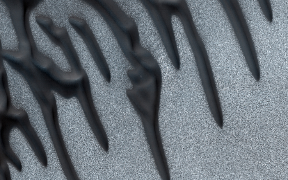
Mars lost a part of its atmosphere to space, a process that transformed the planet from a wet planet into a cold and arid place. The extension and timing of this climatic change are still uncertain. To assess the magnitude of this environmental change we must investigate the Martian geological record. Sedimentary deposits of aeolian origin are common on Mars (Image 1) and may provide valuable information about Martian environmental changes. However, we first need to understand how the diverse bedforms that exist on Mars’s surface form, and evaluate the boundary conditions that control their morphologies. Particularly, relationships between the size of aeolian bedforms and variable atmospheric density may be used to interpret the sedimentary record and infer paleo-environmental conditions through time.

Image 1: Barchan dune covered by dark-toned ripples with spacings between crests of ~3 m. These bedforms are migrating over brighter-toned transverse aeolian ridges (TARs). HiRISE image ESP_027864_2295_COLOR (credit: NASA/JPL/University of Arizona).

(more…)
Titan’s dune fields scanned in the microwave: revealing their true nature

Post by Dr. A Lucas, CNRS Research Scientist, Université de Paris, Institut de physique du globe de Paris, CNRS, F-75005, Paris, France

Titan, Saturn’s largest satellite, has proved to be a world that is both strange and yet so familiar to us. Mountains, lakes, drainage systems and dune fields (Images 1-2) cover its surface. Methane on Titan occupies a similar position to water on Earth. It participates in climatic cycles. Moreover, its photodissociation in the upper atmosphere is responsible for the soot rains that fall on the surface of this icy world. The fate of these grains composed of organic materials is just as essential. Indeed, winds sometimes mobilize them. Over long, very long periods of time, this granular transport is responsible for the formation of vast dune fields located at the equator. But after 13 years of exploration by the Cassini probe, these dunes have not revealed all their secrets. In particular, their morphodynamics are widely debated. Are these bedforms remains from an old time, are they still active today? What is their growth rate? And what is their resulting sediment flux?

Fig1_new

Image 1: Despeckled T8 swath SAR image over the Belet sand dunes located at the Equator of Titan. The dark longitudinal features are the micro-wave absorbent dunes composed of sand made of organics molecules. The bright areas are rough topographic reliefs revealing the icy bedrock beneath the organic sediment cover. Glints (bright spots) are detectable of the crest of some dunes due to specular reflection on their avalanche side.

(more…)

Back to Titan – anticipating the Dragonfly mission

Post by Dr. Stéphane Le Mouélic, Laboratoire de Planétologie et Géodynamique, CNRS UMR6112- University of Nantes, Nantes, France.

Titan is one of the most fascinating bodies of our Solar System. Bigger than Mercury, this satellite of Saturn is veiled by a thick atmosphere of nitrogen containing a few percent of methane. Aerosols formed in the atmosphere by a complex chemistry triggered by the solar UV irradiation produce a global haze totally masking the surface to the naked eye. During 13 years, from July 2004 to September 2017, the Cassini spacecraft orbited Saturn. It took advantage of gravity assist maneuvers to perform 127 equatorial and polar flybys of Titan. Data from the Visual and Infrared Mapping Spectrometer (VIMS) onboard Cassini revealed the distribution of the main compositional units of the surface of Titan (Image 1). The inset in Image 1 shows the 84 km-diameter Selk crater, one of the primary targets chosen for the next New Frontier “Dragonfly” mission, a mobile rotorcraft-lander planned to be launched in 2026.

Image1_SLeMouelic_ann75

Image 1: False color composite of Titan with the red controlled by the 1.59/1.27 µm, green by the 2.03/1.27 µm and blue by the 1.27/1.08 µm band ratios. The equatorial dune fields appear in a consistent brown color. Selk crater is shown in the inset. Credits NASA/JPL/Univ. Arizona/CNRS/LPG.

(more…)

Measuring Cross-Bed Geometry in Upper Aeolis Mons, Gale Crater, Mars

Post by Dr. Ryan B. Anderson, Astrogeology Science Center, United States Geological Survey

One of the most environmentally diagnostic features of sedimentary rocks is cross-bedding, which occurs when sediment is transported by wind, water, or volcanic processes, resulting in horizontal strata composed of inclined beds. The geometry of cross-bedded sedimentary deposits provides information about the depositional setting and post-depositional history of the rocks, making the identification, measurement, and interpretation of cross-beds particularly interesting on Mars, where past conditions are of great scientific interest. This post describes cross-bedding in Upper Aeolis Mons in Gale crater (Image 1).

gale_xbeds_fig1

Image 1: Example of complex bedding patterns in upper Aeolis Mons, interpreted to be large-scale aeolian cross beds. Image is an inset of HiRISE observation PSP_001620_1750.

(more…)

What is happening in Titan’s equatorial belt?

Post by Jeremy BrossierDeutsches Zentrum für Luft- und Raumfahrt (DLR), Institute of Planetary Research, Berlin, Germany.

During the last thirteen years (2004 – 2017), the Cassini-Huygens mission allowed a real revolution in the exploration of Titan, the largest moon of Saturn. This mission has revealed that Titan is – in many aspects – very similar to Earth. Titan is a frozen version of Earth, where methane behaves as water, and water ice may be as hard as rock. Despite its strange characteristics, Titan undergoes a rich variety of surface processes that are likewise analogous to those on our planet. Titan being entirely shrouded by a dense atmosphere made of dinitrogen, methane and solid organic particles (i.e. tholins), direct observation of its surface is only possible through radar data, as well as infrared data within specific wavelengths intervals. SAR images from the radar, allowed identifying various landscapes on the moon (see Image 1), and evaluating their global distribution, notably for the lakes and dunes. Lakes are mostly confined around the poles, while the dunes dominate the equatorial belt. Thus, the shape of Titan’s surface seems quite well understood thank to SAR images, however, it is crucial to determine not only the morphology, but also the nature of the material composing or coating the various landscapes to better understand the geology of this intriguing moon.

Image1

Image 1: A few examples of Titan’s landscapes seen through SAR images, including (A) mountain chains embayed by plains, (B) undifferentiated plains, (C) impact crater, (D) dunes, (E) river channels, (F) small lakes, and (G) a close up of the second largest sea, namely Ligeia Mare. SAR images were acquired during Titan flybys (A, B) T43 in May 2008, (C) T77 in June 2011, (D) T21 in Dec. 2006, (E) T44 in May 2008, (F) T19 in Oct. 2006, and finally (G) T28 in April 2007. Note that Titan flybys are tagged with the abbreviated target name “T” and the flyby number.

(more…)

Large aeolian ripples on Mars

Post contributed by Dr. Ryan C. Ewing, Department of Geology and Geophysics, Texas A&M University

Ripples cover the surfaces of sand dunes on Earth and Mars. On Earth, ripples formed in typical aeolian sand (e.g., 0.1 and 0.3 mm) range in wavelength between 10 and 15 cm and display a highly straight, two-dimensional crestline geometry. Ripples are thought to develop through a process dominated by the ballistic impacts of saltating sand grains in which wavelength selection occurs through the interplay of grain size, wind speed, the saltation trajectories of the sand grains, and ripple topography.

2d_ripples_DeathValley

Figure 1: Wind-blown impact ripples from Mesquite Flat Sand Dunes, Death Valley, USA. Pen is ~15 cm. Inferred transport direction is to the right on the image. Image credit: Ryan C. Ewing

(more…)

Linear-Lee Dunes on Mars and Earth

Post by Haim Tsoar.

The discovery of dunes on Mars:

Mariner 9, launched on May 30, 1971 conducted an intensive orbital reconnaissance of the red planet between November 14, 1971 and October 22, 1972. One of the astonishing discoveries of Mariner 9 was vast dune fields all over the Red Planet. Viking discovered many more dune fields in the late 1970s. However, the resolution of the images taken by Mariner 9 and Viking 1 and 2 was very poor and one dominant dune type of barchan and transverse dunes was chiefly discerned by this low resolution (Tsoar et al, 1979). The Mars Global Surveyor (MGS) was the next successful mission to Mars, launched 20 years after Viking, in November 1996, and operated for 10 years. The Mars Orbiter Camera (MOC) on board MGS acquired high resolution images of the sand dunes on Mars and revealed some other dune types that were not known before. The latest mission to Mars, the Mars Reconnaissance Orbiter not only reveals the variety of dunes but its high resolution camera (HiRISE) allows us to see the smaller ripples on the dunes.

Dunes West of Hellas Planitia, Mars

Image 1: Barchan and linear dunes west of Hellas Planitia near 41.8°S, 315.5°W, formed on the floor of a crater and extending from a mesa. Note the breakdown of the rectilinear dune into barchans with distance from the flow obstruction. HiRISE Image PSP_007676_1385.

(more…)

Longitudinal dunes on Saturn’s moon Titan

Posted by  Dr. Jani Radebaugh, Department of Geological Sciences, Brigham Young University, Utah, USA

(Re-posted from IAG Image of the Month, September, 2007)

The Cassini spacecraft is in orbit around Saturn, and occasionally flies close to one of its many icy moons. Because of specially designed instruments on Cassini, the surface of Saturn’s largest moon, Titan, enshrouded in a thick, hydrocarbon haze-rich atmosphere, has been observed for the first time by this spacecraft.

Dunes on Titan

Cassini RADAR SAR image is north up, with resolution ~300 m. RADAR illumination direction and inclination angle is indicated by the open arrow. Image courtesy of the NASA Cassini Project.

(more…)

  • Enter your email address to follow this blog and receive notifications of new posts by email.

  • Io

  • Blog Stats

    • 191,943 hits